How do we get a gauge on the Fish? It looks like they have an old gauge house downstream
on river left. Did they used to have one and it was shut down? With the help of AW, is there
a way to get a gauge? I, myself, live 10 minutes from the Fish. I have no problem checking
the gauge when people are wondering. BUT, I would love to have a gauge there. It seems
whenever the Fish is running there are about 5 or 6 different out of state liscense plates!
I'm sure these people would reap the benefits of a gauge. Just curious on some feedback.
Tim aka NYKayak1
A light snow is falling and the water and air temperatures combined do not top 70? F, yet a
small team of boaters stand in a cloud of breath by the headwaters of West Virginia's Otter
Creek. Though the channel is only about four feet wide and eight inches deep, this team knows
that there will be water on the river today since the USGS' Dry Fork streamgage is measuring
over seven feet. In fact, this day is going to be epic and boaters are going to be running
all the local steepcreeks from Red Run to the Blackwater, and easier runs from the Dry Fork
to the Shavers Fork.
In October, American Whitewater rescued USGS streamgages from the ax on the Blackwater, Dry
Fork, and Shavers Fork. Operations at 18 popular stations were
threatened due to proposed budget cuts. We were successful in saving these gauges because
so many members and supporters wrote or called the Governor, tourism office, and USGS.
After AW's intervention, the West Virginia Office of Emergency Services hosted a meeting on
October 25 with several interested State agencies. This coalition of agencies worked together
to identify funding sources and ensure no interruption of gauge records or warnings would
occur.
Dear friend of West Virginia,
Thanks for your e-mail expressing concern about the potential closure of 18 water gauges in
our state. Your e-mail, among many we received, prompted our office to quickly find answers
ourselves. On Friday, Oct. 25, West Virginia Tourism along with several other state agencies
and vested parties met to discuss the situation. Below is a statement released late Friday by
the lead agency, the state Office of Emergency Services. Here at the Division of Tourism, we
hope it relieves any uneasiness you have about the stream gauges. On a personal note, thanks
for your continued support of our tourism industry and passion for one of our state's
greatest activities on some of the best waterways in the country. If you haven't been to our
website lately, www.callwva.com, I encourage you to do
so to get the latest on happenings around our state.
Best regards,
Tony O'Leary
Outdoor Recreation Specialist
West Virginia Division of Tourism
Stream gauges to remain open
CHARLESTON, WV -- The West Virginia Office of Emergency Services (WVOES) is pleased to
inform you that a cooperative agreement has been reached with the U.S. Geological Survey
(USGS) that will permit USGS to continue providing stream gauge data on the USGS web site.
This means long-term stream flow data used by citizens, businesses, local governments and
other state and federal agencies will remain accessible on the Internet.
Previous reports by USGS stating that 18 West Virginia stream gauges would cease to operate
on October 31 were simply not factual. In discussions between USGS and the WVOES, it was
never intended for these gauges to be terminated for removed by WVOES. The maintenance
agreement between USGS and WVOES is being terminated, transferring maintenance and upkeep
responsibility for these gauges to WVOES. These gauges will continue to monitor stream stage
conditions for flood warning, as well as stream flow information for historical planning
purposes.
The cost savings realized by WVOES in assuming responsibility for these 18 gauges will permit
the State of West Virginia to expand the number of stream and rain gauges throughout West
Virginia in the coming years. This will provide our state citizens and visitors to the state
with even greater flood protection by adding gauges to streams that are not adequately
covered or that have no gauges at all.
WVOES recognizes the importance of having stream flow data available for monitoring and
predicting flood plains, droughts, as well as for planning a fishing, whitewater rafting or
kayaking trip. This need is now balanced with the need to expand the present flood warning
system without incurring additional costs.
Why is gauge spelled so many ways?
Streamgage spelling is a schizophrenic art.
While most spellings use the classic "gauge" the "gage" spelling without the "u" has
recently come into vogue. The USGS is now using the "u"-less spelling in most locations;
however, this has not yet become the standard and most of the USGS partners continue to use
the "u".
AW has chosen to continue using the spelling with the "u" when referring to a gauge and the
spelling without the "u" when referring to streamgages. AW's spelling reflects the historic
standard and is consistent across the decades.
|
The two examples in the sidebar demonstrate the common range of streamgaging issues that
American Whitewater works on for our membership: advocating for new or restored gauges, and
saving gauges. Our strategy for working on both issues is direct; we leverage our volunteers
and economic interests throughout the State and show the dual values of the gauges for
facilitating recreation and improving public safety.
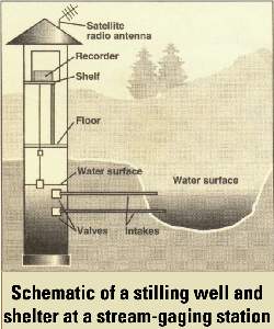
A typical streamgage that provides realtime data costs about $10K to maintain each year.
Maintenance includes provisions for a dedicated phone line, removal of logs and other debris
that wash up against the structure, cleaning the unit of algae and sediment on a periodic
basis, routine calibration, and otherwise making sure that the mechanisms work the way that
they are supposed to. Each of these actions require a technician to visit the gauge, which is
often in a remote part of the state or far from the technician's office. Typically, the more
remote or dynamic the river is, the more it costs to maintain the gauge because it takes more
man hours to manage.
Funding for these gauges comes from a variety of sources: USGS, state agencies such as the
Office of Emergency Services, federal agencies such as the Army Corps, private dam operators
and owners, and even universities or other institutions that are collecting data on
streamflow trends. The USGS is the largest clearing house for this information. The agency
collects the data from all these sources and distributes it for free via the Internet. Some
non-governmental organizations, such as American Whitewater then massage this data and
redistribute it in a format that is most useful for recreationists. AW provides this data at
www.americanwhitewater.org/gauges/.
When the USGS gauges in West Virginia were threatened in Fall 2002, the agency characterized
the contributions of the gauges:
Since 1887, the U.S. Geological Survey (USGS) has operated a National Streamgage Network
to collect information about the Nation's water resources. Under this program, the USGS
collects the streamflow data needed by Federal, State, and local agencies for
water-resource planning and management activities including predicting magnitude and
frequency of floods and droughts, determining 100 year flood plains, evaluating and
allocating water for public and industrial supplies, designing highways and dams, and
permitting sewage and industrial discharges. Real-time streamflow gages are also used to
monitor floods and droughts, and for planning recreational activities such as fishing and
boating.
AW has long advocated for increased funding for the streamgaging program. As
described by the USGS, we have found that the streamgaging network is one of the most
effective government programs in promoting public health and safety. Gauges are used to
predict and monitor flooding, predict and monitor safe drinking water supplies, predict and
monitor instream flows and temperatures for fishery protection, and provide real-time flow
information for river recreationists including fishermen and boaters.
Hazard mitigation and reduction begins with the distribution and collection of good and
reliable data. Cuts in USGS funding reduce the sensory capacity of the streamgage network and
effectively bury the government's head in the sand. Funding cuts come at increased risk to
public safety, while also impacting opportunities for river recreation.
AW is working proactively with the USGS to identify the most important recreational
streamgages. We are identifying these gauges via hits on our website. These hits take two
forms: the first are simple visits to each streamgauge page; and the second are from the
gauges that the registered users on our website have selected in their preference settings in the "MY
GAUGES" field.
STEP 1: The first step to saving a gauge is learning why it is threatened. This
information should be available from the District Chief or other District staff. We generally
recommend going straight to the Chief though, because as AW Regional Coordinator Don Kinser
says, "I like going to the top where I can learn what's going on and make sure my interest is
reflected downwards on the people who will be doing the work." Give yourself 5-10
minutes.
STEP 2: Learn who the cooperating agencies are that have historically provided funding
in the past for the streamgage you care about, or other gauges in the region who may have a
stake in protecting your gauge. Again, the USGS District staff should be able to help you
identify those state and federal agencies. Give yourself 10 minutes.
STEP 3: Identify the head of the State Tourism Department and the Governor. We
recommend doing a quick search on the
"State Tourism Director Contact" and "State Governor Contact" to find this information.
Give yourself 5 minutes.
STEP 4: Pull the information together from the first three steps in a short email
alerting your paddling partners of the threat. Craft a simple message:
Please help to save this streamgage. The gauge is vital to recreational whitewater boaters
and fishermen. The gauge is threatened due to a lack of a few thousand dollars. However the
economic benefits to the local community make this a valuable investment. On an average
trip to the river I spend $110 in the local community. When paddlers know that the river is
at a good height, as many as 20 will visit on a typical day. Etc.
Post this information on Boatertalk and AW Forums. Send a copy to AW's
Access Director. Give yourself 15
minutes.
STEP 5: Draft a short letter to the agencies and individuals
you identified in Steps 1, 2, and 3. Be sure to make arguments regarding the economic value
of the gauge for recreation and tourism, and the public safety value for purposes of flood
warning and the safety of instream recreationists such as fishermen. Send the letter and post
copies of it in the same places you sent the alerts to in Step 4. Give yourself 10
minutes.
STEP 6: Call the Governor, District Chief, and Tourism Director and express your
interest in saving the gauge. Give yourself 15 minutes.
STEP 7: At this point, you could step back and just watch the emails and phone calls
roll in from your paddling partners and allies at AW and Boatertalk, or, and this is what we
advise, you could try to hit a home run by calling the local state representatives and
talking with them too.Give yourself 15 minutes.
Just a handful of calls to the local state representatives from in and out of state will
often rattle the representatives and secure promises of saving the gauge.
Good luck!
When was the last time you went to your favorite river without knowing the level
beforehand? Probably sometime in the 1990's. Right? How much do you normally spend on a trip
to the river for gas, food, & drinks? Probably $10 to $50. Right? Multiply that times 800,000
to 1,000,000 whitewater boaters who boat at least 15 days each year. If you spend a minimum
of $10 per trip, then that amounts to a conservative estimate of $120 Million that whitewater
boaters contribute to the economy solely on travel expenses as the result of knowledge about
river levels. When you add in paddling gear purchases, vehicle maintenance, and other
lifestyle purchases, the sum measures in the billions. When you measure the savings from
flood prediction and monitoring, reduced insurance claims, as well as provisions for safe
drinking water, the number soars into the tens of billions. That is the real value of the
streamgaging network to America's domestic economy, and that is our strongest argument for
protecting the network for recreation.
When you write a letter or make a call to an agency or representative to protect a gauge
explain:
- How you use the streamgages for trip planning purposes.
- That these streamgages are on some of the best whitewater in the state.
- How often you visit the river or area for kayaking, rafting, or canoeing.
- How much you spend on an average trip or during the course of the year. The goal is to
make the value of these gauges apparent to state's tourism economy.
- Also, if you live in the state, write a letter to the editor of your local paper
sharing this information, and alerting the editor of the problem this will cause for river
recreation and local business in the state.
AW volunteers Adam Cramer, John Tingerthal, Don Kinser, and Tom O'Keefe prepared the
following messages to send to USGS and Department of Tourism during the crisis in West
Virginia. Please feel free to crib from them if your favorite gauges are threatened. WHen you
send your letter, copy AW at access@amwhitewater.org and let us know who you are
writing to.
EXAMPLE 1
Dear USGS District Chief and West Virginia Division of Tourism:
I understand that operation of some of the river gauges in West Virginia, such as the
Blackwater gauge, might be terminated. This would be a great loss for the East Coast angling
and whitewater communities, as well as West Virginia's tourism industry.
Speaking as a kayaker, I use the gauges as a critical trip planning tool because these rivers
are runnable only at certain water levels (e.g., the upper section of the Blackwater is
generally run between 150 and 400 CFS). Although the northern part of West Virginia offers
some of the best and most scenic whitewater runs in North America, without a reliable gauge
reading via the internet, I would make substantially less visits throughout the year (I live
in Washington, D.C., a 3 to 4 hour drive).
More importantly, terminating these gauge operations would adversely impact West Virginia's
tourism industry. Upon a favorable gauge reading, I'll likely make the trip with 3 to 4 other
people (mostly from the DC area), and we'll each spend at least $50 to $60 in West Virginia
on gas, food and lodging. Moreover, these trips often take place throughout the year -- not
just during the typical summer tourist season.
Please do not terminate these gauges.
EXAMPLE 2
Dear USGS District Chief and West Virginia Division of Tourism:
I am upset that the USGS is cutting many of the West Virginia river gages. I use these gages
to plan kayaking trips to West Virginia. As a resident of Chicago, that means 10 to 12 hours
of driving. I spend at least 6 weekends out of the year visiting this area. The gages provide
extremely important information for me and I would hate to see them go.
EXAMPLE 3
Dear USGS District Chief and West Virginia Division of Tourism:
I have just learned that recent reductions in state matching funds is expected to result in
discontinuation of 18 stream gauges in West Virginia effective October 31, 2002. Each year I
typically visit northeastern West Virginia three time a year, totaling nearly 20 days, to
enjoy the awesome whitewater rivers and streams of your great state. The 18 impacted gauges
are on some of the best whitewater streams in West Virginia. I am very upset to learn of this
situation because I rely on these gauging stations in my trip planning and in determining my
itinerary.
I estimate my family and I spend nearly a thousand dollars each year on gas, lodging, meals,
etc on these whitewater paddling trips. Without the reliable information provided by these
gauges I will be less willing to travel the great distance from my home in Georgia on the
chance that the rivers I want to paddle have adequate flow.
You should understand that gauges are extremely valuable to West Virginia's tourism industry
and that funding should be restored to insure these gauges remain operational.
EXAMPLE 4
Dear USGS District Chief and West Virginia Division of Tourism:
I have recently been notified that several important USGS gauges in the state of West
Virginia will be cut from the national streamgaging network at the end of this month. In
addition to their important role in safety and providing a long-term data record of high
value to hydrologists, several of the gages are extremely important for recreational river
users. Although I live on the west coast, I have taken two trips to West Virginia over the
past year specifically for the purpose of whitewater kayaking. In both cases access to the
real-time gage data was a major factor in planning my trip (during the trip I took in March
the data provided caused us to make a last-minute change in plans to paddle the West Virginia
streams rather than others we had originally planned to visit in North Carolina). In short,
access to the discharge data greatly enhanced the quality of my experience and the efficiency
of my trip. Having access to these data is often the deciding factor in whether a short trip
to the east coast is worthwhile for me (I most typically fly out for a long weekend).
My two trips this year to West Virginia represented a total contribution of well over $1000
to the local and national economy. On each trip I spent approximately $300 on a plane flight,
$125 in local travel expenses, $80 in lodging/camping, $150 in meals/food, and $100 in
miscellaneous items. Since we were traveling in a group, the others I traveled with made
similar financial contributions to local tourism.
While I recognize that funding is tight and difficult choices have to made, I ask you to
carefully consider the value of the stream gaging program for whitewater recreation in West
Virginia. The annual cost of maintaining a station is very small compared to the benefit
realized by users like myself from across the country. It's unfortunate that while you have
made considerable improvements in the accessibility of your data (without a doubt the USGS
provides government-funded data in the most useful and accessible format of any agency web
site--you truly set the standard!), funding the instrumentation and personnel to maintain it
has become such a challenge.
I ask that you work closely with American Whitewater and local paddlers in identifying gages
that are of primary importance to river recreation and explore creative solutions for
continued maintenance of these important stations.
|

