Canyon Creek Access Improvements
As part of the relicensing for the Lewis River Hydroelectric projects, PacifiCorp was required to address recreational sites on their reservoirs. One site of interest to whitewater paddlers is the access used as a take-out for the popular Canyon Creek run. As part of their recreation plan, PacifiCorp proposed improving the take-out trail, currently a muddy scramble up the bank, to address erosion issues and improve safety. They would also formalize the public parking at the Highway 503 bridge for recreational users, making this an approved use of the site. These enhancements will directly benefit the whitewater community and perhaps more importantly will serve to formalize whitewater recreation on Canyon Creek, a use that has been threatened in the past by a proposed small hydro project.
On April 18th, 2003, American Whitewater met with a representive of PacifiCorp and individuals from the Portland area boating community to discuss the proposed elements of the recreation plan that would affect Canyon Creek boaters. PacifiCorp's proposed enhancements were favorably received and the letters below document the discussion. Actual work on the project would not begin until the utility receives a new license from FERC which will likely not occur until sometime in early 2006. [update: license issuance has been delayed and we are now expecting a new license in 2008].
**************************************
February 11, 2003
Mark Stenberg
PacifiCorp
825 NE Multnomah, Suite 1500
Portland, OR 97232
RE: Whitewater Access Sites and Flow Information
Merwin Hydropower Project, FERC Project No. 935
Dear Mr. Stenberg:
Thank you for your recent note confirming PacifiCorp’s proposed plan to improve the access point for non-motorized craft at the Yale Bridge (Highway 503) on the Merwin Reservoir as a condition of relicensing for the Lewis River projects. We are reviewing this proposal among our constituency. We would also like to bring to your attention the need for real-time flow information on Canyon Creek and the East Fork of the Lewis River. These popular whitewater runs are tributaries to the Lewis River and due to project impacts on whitewater recreation opportunities are warranted as mitigation.
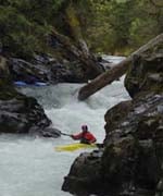
The dams and associated reservoirs associated with the series of hydropower projects on the Lewis River have buried the natural river channel of Canyon Creek at it’s confluence with the Lewis River and countless miles of the Lewis. This conversion of many river miles to reservoir has greatly impacted whitewater boating opportunities. Presently, boaters running the popular whitewater run on Canyon Creek must paddle 1.5 miles of flatwater on Merwin Reservoir and then ascend a steep muddy bank to the take-out.
We understand that some time in the next two months additional scoping for this project will take place. In this scoping phase or before we ask that PacifiCorp also explore alternative sites for a take-out particularly a site that would eliminate the 1.5 mile flatwater paddle. Whitewater boats are not designed for flatwater which makes this part of the Canyon Creek run very unappealing. A take-out on PacifiCorp land closer to the mouth of Canyon Creek may be more desirable than the existing site at the Yale Bridge. Several alternative sites should be considered in this scoping. We would be happy to work with you on a list of possible sites.
Kayakers need very little if anything in the manner of infrastructure. The most important item requested by the recreational whitewater community is a take-out site with an agreement for the life of the license. We look forward to working with you in developing a schematic design for the respective alternative sites. We favor a low level of development that can be easily maintained and is not obtrusive to the natural setting.
The loss of whitewater opportunities on the mainstem Lewis River has forced paddlers to seek whitewater opportunities on tributaries to the Lewis River. Canyon Creek and the East Fork Lewis River have provided two such opportunities. We request that PacifiCorp provide internet and toll free phone line accessible flow information for each of these runs. PacifiCorp should ensure continued operation of the East Fork Lewis River gauge (USGS 14222500) and public availability of real-time data for the life of the license. PacifiCorp is currently a cooperating partner in the operation of this gauge. We request PacifiCorp continue as a cooperating partner for the life of the license. No publicly accessible real-time stream gauge currently exists for Canyon Creek. As mitigation for the Lewis River hydropower projects, PacifiCorp should establish a stream gauge accessible to the public for Canyon Creek.
Sincerely,
Thomas O’Keefe
**************************************
April 26, 2003
Mark Stenberg
PacifiCorp
825 NE Multnomah, Suite 1500
Portland, OR 97232
RE: Whitewater Access Sites and Flow Information
Merwin Hydropower Project, FERC Project No. 935
Dear Mr. Stenberg:
Thank you for taking the time to meet with myself and members of the Portland boating community on 18 April 2003. We appreciate your commitment to recreational facilities associated with the Merwin Hydropower Project and believe that by continuing to work in cooperation, it will be possible to provide some minor but welcome improvements to whitewater recreational opportunities on Canyon Creek.
After reviewing the alternative take-out sites you presented to us, it does appear that designating the Yale Bridge (Higway 503) as an access point for non-motorized recreation represents the best course of action at this time. In developing the site at the Yale Bridge we support the minimal level of development that has been proposed. The set of stairs will improve safety for those climbing up to the parking area, but otherwise, kayakers need very little if anything in the manner of infrastructure. The most important item requested by the recreational whitewater community is a formal access site with an agreement for the life of the license. We favor a low level of development that can be easily maintained and is not obtrusive to the natural setting.
Alternative sites off Frasier Road on the north side of the reservoir and slightly upstream of the currently-used bridge access would shorten paddling distance only a minimal amount and add significantly to the time required to run the shuttle and hike out. The ideal site would be at the point where Canyon Creek joins Merwin Reservoir along the east (river right) side of the creek, but we understand that there is currently no public vehicle access to this area and that future plans call for a trail to provide non-motorized access along the shores of Yale Reservoir. If public vehicle access to this area is allowed in the future, development of a river access would be a high priority and add considerably to the quality of Canyon Creek as a whitewater run by eliminating the flatwater paddle on Merwin Reservoir. Boats that are specialized to run a technical river like Canyon Creek are not designed for flatwater paddling, and aside from lost whitewater beneath the reservoir, this is currently the most significant impact the Merwin Project has on whitewater recreation on Canyon Creek. In our meeting you indicated that PacifiCorp will conduct preliminary planning for a non-motorized recreation trail that would cross Canyon Creek (utilizing the logging road bridge midway along the run) and continue up along the shores of the Yale Reservoir. In the planning stages of this project we request that PacifiCorp include river access by means of a trail at the point where Canyon Creek joins Merwin Reservoir. Access to the creek at one or two other points along this trail would improve safety by providing designated exit points and could potentially provide paddlers with the opportunity to access sections of the creek by hiking partway back upstream for a second run. These possibilities should be examined during the planning phase for the trail.
The loss of whitewater opportunities on the mainstem Lewis River has forced paddlers to seek whitewater opportunities on tributaries to the Lewis River. Canyon Creek and the East Fork Lewis River have provided two such opportunities. As mitigation for the Lewis River hydropower projects, we request that PacifiCorp continue efforts and work with appropriate partners to provide internet and toll-free phone line accessible flow information for each of these runs. During our meeting you indicated that PacifiCorp had experienced difficulties in establishing a real-time gauging station on Canyon Creek in the past. We have experience working with utilities in providing real-time flow information for whitewater recreation and are willing to provide assistance as appropriate. Some of our members and volunteers have experience with Campbell data loggers and sensors typically used for gauging stations, along with different communication technologies including meteor burst communication systems that might be appropriate for this site. In addition, we have worked with utilities to provide flow information through our web site.
Thank you again for meeting with us. We look forward to working with you in continuing to develop the plan for improvements to recreational opportunities on Canyon Creek.
Sincerely,
Thomas O’Keefe