2009 West Rosebud Flow Program Announced
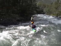
American Whitewater is pleased to announce the 2009 release program for West Rosebud Creek, located in Montana's beautiful Beartooth Mountains. The Mystic Lake Hydroelectric Project has historically reduced paddling opportunities on the Creek. American Whitewater and Beartooth Paddlers are working closely with the dam ownerand other interests on developing a water release program that mitigates these impacts by replacing lost paddling days. We have been studying and revising the release program for the past two years and are optimistic that the 2009 program will greatly benefit paddlers.
Most years water spills over the dam on Mystic Lake in late june or early July and this high flow pulse is quickly reduced through dam operations to flow levels that are just below desired boating flows. Our flow program will provide additional water in the creek on weekends following the spring pulse when flows are too low to support paddling but not yet at base flows. Following the peak, when flows are between 250 and 400 cfs, flow levels will be increased to provide an optimal boating opportunity. Depending on the flows a one or two day releases will be provided. AW will announce when the peak has occured, and paddlers can then easily determine if there will be a flow the coming weekend on the preceeding Wednesday. The dam owner is estimating that the spring peak will occur within the first week of July, and for boatable flows to continue well into August.
Specifically, the 2009 flow program is as follows:
During the descending limb of the West Rosebud Creek spring hydrograph:
- When the Wednesday noon stream flow reported on the USGS Streamflow Gauge West Rosebud Creek near Roscoe MT (#06204050) is greater than 400 cfs, no white water flow enhancement will be provided.
- When the Wednesday noon stream flow reported on the USGS Streamflow Gauge West Rosebud Creek near Roscoe MT (#06204050) is between 286 cfs and 400 cfs, PPLM will endeavor to release 500 cfs for 5 hours from the West Rosebud Lake Dam on the following Saturday and Sunday.
- When the Wednesday noon stream flow reported on the USGS Streamflow Gauge West Rosebud Creek near Roscoe MT (#06204050) is between 250 cfs and 285 cfs, PPLM will endeavor to release 500 cfs for 5 hours from the West Rosebud Lake Dam on the following Saturday only.
- When the Wednesday noon stream flow reported on the USGS Streamflow Gauge West Rosebud Creek near Roscoe MT (#06204050) is less than 250 cfs, no white water flow enhancement will be provided.
White water releases from West Rosebud Lake Dam will begin at 7:30 AM. Peak flow (near 500 cfs) will reach the Emerald Lake Outlet at approximately 11:00 AM and will continue for approximately 2.5 hours, gradually reducing to pre-enhanced base flow conditions thereafter.
Note that the gage listed above is different than the gage listed on the AW river page for this section.
In summary, if you are interested in paddling West Rosebud: check the roscoe gage, if it has already peaked (look for the peak on the graph or check the AW site) and flows are between 286 and 400 cfs on a Wednesday at noon there will be water released to provide optimal boating flows on both days of the following weekend, if flows are between 250 and 286, there will be optimal flows on Saturday only. If flows are below 250, there will not be optimal flows or releases, and if flows are above 400 flows may "naturally" be optimal but there will be no additional release.
IMPORTANT: Upper West Rosebud Creek (the section commonly paddled) is entirely on lands that are open to public enjoyment. Below Pine Grove Bridge, the lower section of West Rosebud Creek flows through private property. Paddlers attempting this section should be aware that several rapids and/or logs will likely require scouting and/or portaging. Landowners are very cordial, but ask that paddlers not scout or portage above the high water mark without prior permission. Please respect the wishes (and rights) of private property owners on lower West Rosebud Creek. If you have any questions about your ability to scout and portage in the active river channel, please contact a paddler with experience on this section prior to paddling it.