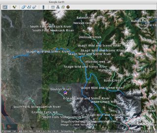
Updated Layer of Wild and Scenic Rivers in Google Earth
The federal agencies have recently updated their maps of all the nation's Wild and Scenic Rivers and in an effort to make this information more accessible to our members and the general public, AW volunteer Alex Zendel has produced a Google Earth layer of Wild and Scenic Rivers based on GIS data available from the federal river management agencies. The map includes the newly designated rivers that were protected with the Omnibus Public Lands Act of 2009 and can be downloaded through the link under Documents to the right.
Using Google Earth you can also view all the rivers in American Whitewater's National Whitewater River Inventory. At the bottom of each of our state pages look for the Google Earth link that allows you to download the .kml file for a state. With this file each of our river pages is represented by a color-coded point indicating current flow conditions. Clicking on the point will take you to the full description of the river on our website. Our ongoing goal is to provide river runners with a more robust understanding of the management guidelines and conservation measures in place for the rivers they enjoy. By integrating the Wild and Scenic River layer with the layer for whitewater rivers you can see how important the Wild and Scenic Rivers Act is for protecting our most treasured whitewater rivers.
Thomas O'Keefe
3537 NE 87th St.
Seattle, WA 98115