Sullivan Creek Dam Removal Images Produced
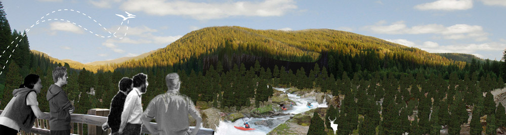
Earlier this year Cody Erhart, a recent landscape architecture program graduate, produced images for American Whitewater depicting what Sullivan Creek (WA) might look like following the removal of Millpond Dam. The dam is roughly 100 years old, and has not generated power for over 50 years. Its removal is part of an agreement in principle signed by American Whitewater, the US Forest Service, the dam owner and several other stakeholders. The images were released at an open meeting in October at which the agreement in principle was rolled out to the public. The images created a forum for discussion both during the meeting and prior to the meeting in negotiations.
The images combine bathymetry data provided by the dam owner which mapped the historic channel beneath layers of sediment, photography of the surrounding landscape and downstream rapids on Sullivan Creek, and several GIS layers provided by the US Forest Service. The result is a series of four images depicting an upstream view from an existing bridge pre-removal, 2 years after removal, 5 years after removal, and 10+ years after removal. In addition, Cody created an overhead map-view of the reservoir area several years after removal.
More science than art, this project has and will continue to help all of us working on Sullivan Creek envision a better future for the Creek.
The images can be viewed as PDF's in the Document Box to the right, and the upstream views can also be viewed as photographs. Enjoy.