MF Snoqualmie (WA) Road Paving Project
For those interested in the future of the Middle Fork Snoqualmie Road and the paving project,
there will be a Scoping Meeting Open House that will take place on Wednesday Nov 19, 2003 from
4-8 pm at the Mt. Si Senior Center, 411 Main Avenue S., North Bend, WA (map).
Public Notice:
This is the continuation of a series of public meetings being held to gain input for the
improvement of the Middle Fork Snoqualmie River Road. A team has been assembled to complete the
public involvement, engineering investigations, environmental documentation and preliminary
design. A summary of comments received to date will be available at the meeting.
We'd like to hear from you-opinions or suggestions, comments on environmental matters, access or
traffic concerns, safety considerations, problems this project could cause or eliminate, plans
that could be affected, alignment and road width alternatives or any other related matters you
think are appropriate.
This will be an open forum meeting. Representatives of the project team will be on hand to
receive your comments and discuss ideas and concepts. This meeting will assist in selecting the
alternatives to be studied and to help finalize the Purpose and Need for the project.
For more information or to be placed on the mailing list contact
Matthew Joerin
Western Federal Lands Highway Division
Federal Highways Administration
610 East Fifth St.
Vancouver, WA 986611
<mfsnoqualmie@fhwa.dot.gov>
Middle Fork Snoqualmie Road Project
web site
This is project No. WA PJH29
Of Interest to Boaters:
The Forest Service recently announced their plan to close the Middle Fork Snqualmie Road upstream
of Dingford Creek (this will likely occur in fall of 2004). At that time a seasonal gate will
also be installed at the Taylor River confluence so the remaining upper portion of the road can
be closed off during the winter months. While this means less convenient access to the upper
watershed, it means the Forest Service will be able to consolidate management activities and
resources on the lower watershed while providing new opportunities for recreation in the upper
watershed. A public concept plan that has evolved over the past 10 years has called for this
action and after a public comment period, the Forest Service recently issued a decision to begin
implementation starting this next year (read more about it
here).
The Federal Highways paving project is not directly related to the Forest Service action but
would involve paving the road from the current pavement end to the Taylor River confluence. There
is currently a trailhead here and next summer construction of a new Forest Service Campground
will likely begin. Recognizing that the era of resource extraction is over, members of the
public, public agencies, and local communities are working together to make the valley more
inviting for recreational opportunities. We will want to watch this paving project carefully and
I would encourage boaters to stay informed and provide comments. In theory we could see
improvements through decreases in sediment delivery from the road and development of nice
roadside pull-outs at key access points along the river. American Whitewater and our local
affiliates are currently working with King County, WA DNR, City of North Bend, and USFS to
identify the important access sites and improve the existing informal trails to address erosion
issues and enhance visitor experiences. We will also want to inform Federal Highways of the
importance of protecting the river itself. This is still the scoping process but be sure to let
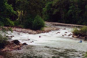
them know how important the little playspot at the bottom of Island Drop is and that we don't
want a bunch of boulders and associated rip rap randomly piled in the river there. You might also
request safe and legal off-road parking or pull-outs at Island Drop (aka old Mine Creek
Campground), the Lake Dorothy Road Bridge (aka Concrete Bridge), and Pratt River Bar (an
intermediate access point on the Upper Middle). In considering the scope of this project, think
about what you would like the valley to look like. I would suggest that we want a paved forest
road as opposed to a full-blown highway. This is the stage where the scale of the project will be
determined. Most importantly, identify yourself as a boater with a strong interest in the Middle
Fork of the Snoqualmie. If we are recognized as an important user group with an interest in the
river and future development of the transportation plan it will assist in making sure our needs
are met.
Please send a copy of your comments to John Gangemi, AW Western Director <jgangemi@digisys.net >, and Tom O'Keefe <okeefe@riversandcreeks.com>, WA Regional Coordinator
so we can make sure that any comments AW files are consistent with the interests of boaters.
Additional Background from Federal Highways
The FHWA, in partnership with the U.S. Forest Service, Washington Department of Transportation
and King County, Washington, will prepare an environmental impact statement (EIS) on a proposal
to improve Washington Forest Highway 29 locally known as the Middle Fork Snoqualmie River Road or
Lake Dorothy Road. Forest Highway 29 begins at Interstate 90 (M.P. 34) and terminates at the
Middle Fork--Taylor River Trailhead. The entire Forest Highway route is 12.1 miles. The proposed
project will improve the uppermost 10.74 miles.
The Middle Fork Snoqualmie River Road is the gateway to 109,000 acres of National Forest land and
a primary access point for the Alpine Lake Wilderness. The road is located in the eastern half of
King County, less than an hour drive from the population in the Seattle area. There is high
recreational usage along this route which must accommodate a diverse mix of users including
bicyclists, pedestrians, cars, recreational vehicles, timber haulers and trucks.
The existing road is paved for the first 1.3 miles with the remaining portion being gravel.
Roadway widths vary from 15 to 28 feet and are not safe to accommodate the mix and volume of
traffic. In addition to narrowness, the road surface ruts and potholes badly during winter months
causing unsafe and erratic driving conditions. The present road surface is nearly unbladable for
maintenance because of the absence of cushion and graded aggregate. The road also is deficient in
drainage causing silt laden runoff to empty directly into surface waters. The overall purpose of
the proposed project is to improve the physical conditions and safety features of the Middle Fork
Snoqualmie River Road for the existing and projected traffic demand, while minimizing adverse
impacts to sensitive environmental resources.
Project objectives will be based on the needs developed during the scoping process. All
improvements must be consistent with the applicable guidelines from the Mt. Baker-Snoqualmie
Forest Plan, the Middle Fork Snoqualmie Access/Travel Plan, King County plans and ordinances,
Washington State regulations and federal regulations.
Alternatives under consideration include (1) taking no action; (2) improving the existing two
lane road to meet the appropriate Washington state design criteria; (3) improving the existing
two lane road to meet the appropriate American Association of State Highway and Transportation
Officials (AASHTO) design criteria; (4) other alternatives that maybe developed during the NEPA
process.
Notices describing the proposed action and soliciting comments will be sent to appropriate
Federal, State, and local agencies, and to private organizations and citizens who have previously
expressed interest in this proposal. Based in part on data collected and comments received, FHWA
has determined that it will prepare an EIS on the proposed project. Comments previously received
will be utilized during the EIS process. Additional interagency and public scoping activities
will be conducted. The time and place of the public scoping activities will be provided in the
local news media and by notice to individuals and agencies that have expressed interest in the
proposal. The draft EIS will be available for public and agency review and comment. Schedules for
these activities will be distributed when available this summer.
To ensure that the full range of issues related to this proposed action are addressed and all
significant issues identified, comments and suggestions are invited from all interested parties.
Previous comments received by FHWA have identified a number of issues such as impacts to private
landowners, water quality, wetlands and wildlife, as well as slope stability, tree removal and
parking along the roadway.
Funding for this project in the amount of $1,742,000 was designated by Congress in the FY 2000
DOT Appropriations Act (Public Law 106-69) conference report (House Report 106-355).