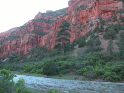
Working Group takes on future management of Lower Dolores River
American Whitewater and various stakeholders have formed a Working Group in the Lower Dolores River Valley to update the 1990 US Bureau of Land Management’s Lower Dolores River Management Plan. The Working Group, which is organized by the Dolores River Dialogue, hopes to develop and evaluate alternatives to Wild and Scenic River designation on the Dolores below McPhee Dam, that can protect existing water rights and contractual obligations, while supporting the “Outstandingly Remarkable Values” that make the lower Dolores River suitable for inclusion into the Wild and Scenic Rivers system.
The one year process outlined below in Phases 1-3 will be followed by an additional 6 month phase for the completion of a formal Environmental Assessment and Decision Notice for adoption of the update of the 1990 Corridor Management Plan. The process will be organized by the DRD in cooperation with the Dolores Public Lands Office of the San Juan Public Lands Center which manages land and recreation for BLM and and National Forest Lands along the Dolores River from it’s headwaters on Lizard Head Pass to McPhee Reservoir, and from McPhee Reservoir to eight miles below the confluence of the San Miguel and Dolores Rivers.
Meetings during all phases of the process will be open to the public, and opportunities will be provided for public comment.
Phase 1: October 2008 February 2009
Baseline information, Issue Identification, Evaluation of ORVs.
Phase 2: March - June 2009
Demonstrate Adaptive Management within Available Water Budget, Gather Field Data with a Focus on ORVs
Phase 3: July - September 2009
Continue Field Work, Conduct Field Trips, Formulate Alternatives and Proposed Alternatives and Actions for Formal EA process in Phase 4
Phases 1-3 will involve and estimated 10 formal working group meetings, numerous work sessions, and 2-3 field trips. All of the information developed in Phases 1-3 will provide the basis for Phase 4.
Phase 4: October 2009- March 2010
Formal Environmental Assessment
Nathan Fey
1601 Longs Peak Ave.
Longmont, CO 80501