Dosewallips River Road Repairs (WA)
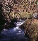
During the winter storm of January 2002, the Dosewallips River Road (FS 2610) suffered major damage at mile post 10. The Dosewallips River washed out approximately 100 yards of adjacent road and part of the hillside behind it. This has impacted public access to the Forest Service Elkhorn Campground which is the take-out for the Elkhorn Canyon run (class V+) and the put-in for the Upper Dosewallips run (Class IV+). It has also impacted access to this eastern entrance to Olympic National Park. Although walk-in access is still available you can no longer transport your boat by vehicle to access this section of river.
The Olympic National Forest released an
Environmental Assessment to consider options and determine appropriate management actions. The
alternatives included
- No action (Alternative A)
- Ending the road short of the washout and developing a trailhead and connecting trail in place
of the current road to the campgrounds and to Olympic National Park (Alternative B, cost
$485,000)
- Reroute the road upslope of the existing washout by constructing a 0.5 mile bypass requiring a
short climb at 12 % grade to the terrace above the river (Alternative C, cost $315,000)
- Reconstruct the road in the original location with engineered structures to protect the road and dissipate streamflow energy (Alternative D, the FS has selected as their preferred alternative, cost $355,000)
Originally the Forest Service indicated a preference for Alternative D. Local paddlers raised objections to this alternative because it involved reconstructing the road in the middle of the river channel (that had migrated to occupy the position of the former road bed) and would have involved extensive engineering to keep it there, that could have in turn created hazards to recreational river users. When these highly engineered structures fail, and they eventually will, it can result in extremely hazardous conditions for paddlers especially when cables, human-placed logs, or rip rap are used. After additional consultation, the Forest Service further determined that Alternative D, would not be consistent with the Aquatic Conservation Strategy (ACS) of the Northwest Forest Plan.
Given this constraint the Forest Service issued a decision to implement Alternative C with modifications (link to additional USFS documents). Specifically,
- The length of the reroute would be approximately 0.74 miles instead of 0.50 miles (to reduce
the grade).
- The engineering estimate for the road work is $556,000.
- The modified alternative would decommission approximately 0.67 miles of Forest Road 2610.
- Grade approach and descent would be approximately 8 to 10 percent instead of 12 percent.
- Modifying the alignment of the bypass would reduce the risk of impacts on the unnamed tributary
channel, which is occupied Coho salmon rearing habitat.
- Approximately 220 trees greater than 21 inches in diameter would be removed affecting approximately 4 acres of late-successional forest instead of 2.5 acres, which is still an area less than one-tenth of one percent of the affected owl habitat circles.
Following this decision, Olympic Park Associates and Olympic Forest Coalition led an effort to formally appeal the Forest Service decision (additional background). With this appeal, a new window of opportunity for public comment is available through May 22nd.
There are a few points of interest to paddlers:
Because the road serves as the primary gateway from the east, FR 2610 is clearly an important access corridor to the Olympic National Forest and Park not only for paddlers but for hikers and campers who regularly take advantage of a wide range of recreational opportunities available throughout the Dosewallips River valley. The National Park Service and Forest Service have invested in significant infrastructure to make this a gateway to the eastern side of Olympic National Park. In a comprehensive analysis of roads throughout the Olympic National Forest, the Forest Service did an excellent job of developing a plan for the road network (additional background). This plan included decommissioning many miles of road representing a significant impact on the aquatic and terrestrial resources of the Olympic Peninsula. At the same time, other roads such as the Dosewallips Road were identified for continued maintenance. By consolidating maintenance funds to key roads like this one overall long-term costs will be reduced.
In addition, the local communities of the eastern Olympic Peninsula have strongly supported reconstruction of this road (additional background). As the timber industry has declined these communities look to new economic opportunities with recreation-based tourism being important.
Developing a new route for the Dosewallips Road represents an innovative solution for pulling roads out of riparian terraces where they are subject to constant maintenance issues. Poorly sited roads such as this one on the Dosewallips and those along the Hoh River, Sitkum River, Quinault River, Matheny Creek and other rivers on land managed by public agencies are prone to chronic failure, resulting in significant expenditures of public funds and persistent detrimental impacts to the Olympic Peninsula's rivers. This approach of pulling the road away from the river has been very effective on private forest lands but has been more difficult to implement on public forest lands where roads often get built back in the same location that they always were (e.g. Mount Rainier's Carbon River Road). In this case however the reconstruction of the road comes at some cost, primarily through removal of a strip of late successional forest.
Paddlers and other recreational users are faced with two issues and should use this opportunity to voice their thoughts with the Forest Service.
- How important is access to the Dosewallips Valley and the associated infrastructure that has
been developed by the National Forest and National Park?
- If access is important, then what is the best means of getting there?
The answer to the first question is one to be answered by individual paddlers. American Whitewater volunteers have communicated with the Forest Service regarding the second question. The preferred Alternative C, in its modified form, addresses concerns regarding many of the future maintenance issues related to the road and safety issues that were raised regarding the potential for in-stream structures associated with Alternative D.
Paddlers are encouraged to share their personal experience and thoughts regarding this road project. The current public comment period is open through May 22nd.
Address comments to:
Linda Goodman
Regional Forester, Region 6
US Forest Service
333 SW First Ave.
Portland, OR 97204
cc:
Dale Hom
Forest Supervisor
Olympic National Forest
1835 Black Lake Blvd SW
Olympia, WA 98512
William Laitner
Superintendent
Olympic National Park
600 Park Ave.
Port Angeles, WA 98362