| Difficulty | I-II+(IV) |
| Length | 3.2 mi |
| Avg Gradient | 30 fpm |
| Reach Info Last Updated | October 15, 2021 |
River Description
Removal of a couple dams revealed a wild set of ledges. Be EXTREMELY careful! The final series land in shallow water sheeting across rock, and most generally SHOULD NOT BE RUN!
The following is edited combined input from two contributors:
A Wisconsin State Park pass is required for all reasonable put-in & take-out parking areas.
Mild rapids start on a bend about 150 yards below CTH.E bridge. At peak snowmelt this section may be well over bank-full and becomes class III- water (very rare but fun), otherwise this is generally Class I-II. (The river tends not to hold water very long after snowmelt or heavy rains, so is usually shallow and not pushy at all.) In summer you will scrape down the next 1.5 miles but usually find routes through easy rapids until CTH.A bridge. There are several small ledges that have micro-surf waves, great for beginners.
After a mile and a half, there is a parking lot on river right at the A bridge (permit required for Willow River State Park). This would be the best place to take out as portaging the falls is difficult and dangerous.
The lower canyon section (below CTH.A) is very picturesque and worth seeing, but that is best done on foot and from shore. This stretch should only be attempted by properly skilled whitewater boaters who have thoroughly scouted the falls area before proceeding (before putting on), and should only be done at normal (low) flows. Beyond CTH.A, there will be about a mile of flatwater with two mild drops. A bluff on the right will signal the lead-in to a canyon. Entering the canyon will commit you to approaching the falls, so keep alert to get out before the falls! ONLY EXPERT BOATERS SHOULD consider proceeding beyond this point in the river! Proceed with caution once the ledges become constant. There will be a horizon line for a 5-foot drop that (at least in medium to low water) splits around a knob of rock at river center. This 5-footer le
...River Features
Put In
Access PointDistance: 0 mi
CTH.A
Access PointDistance: 1.6 mi

This is the recommended take-out for all but the most skilled boaters. Do not proceed beyond here unless you have thoroughly scouted the lower falls section on foot prior to putting on, to have awareness of what you are getting into, and a solid plan for dealing with the ledges and large falls in the lower canyon.
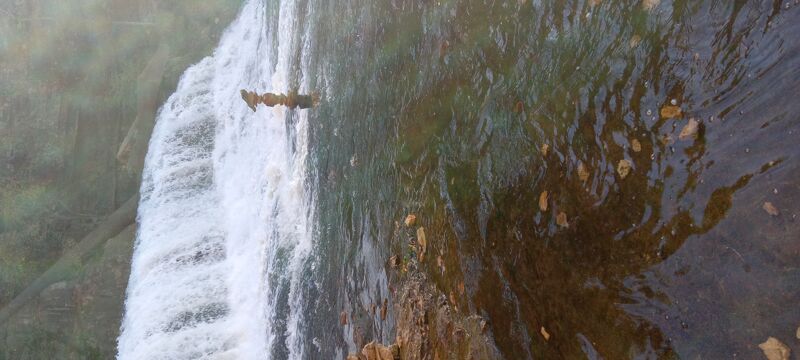
Willow Falls sequence
PortageHazardWaterfall / Large DropClass: IV+Distance: 3.4 mi
EXTREME CAUTION!!! This falls (varyingly reported as anywhere from 12' to 20' tall) all lands very shallow with water sheeting across rocks. Vertical canyon walls make portaging exceedingly difficult. Two lead-in ledges and sliding bedrock make it easy to be swept into and over the larger falls! Do not put-in nor boat beyond CTH.A without first scouting (on foot) the whole falls sequence to carefully assess your skills to handle the drops, flows, eddies, and portage at this falls.
Trip Reports
Log in to add a reportMS
The very last chance to Portage - Max Swenson
Sep 29, 2024
45.0218735, -92.6697337
These are the coordinates for the last point in which a person can take out.
There is a private 'beach' (waterfront) on river right and you will have to trespass. On river left there is an over hang and a bit of a climb up the hill to the state park trail. All should be scouted because there aren't any big discerning landmarks.
Get out on hwy A is probably still the best recommendation especially at high levels.