Sevenmile Creek
Sevenmile Park: Trail 8 to US169 (2.4-5.3 miles)
| Difficulty | I-II |
| Length | 5.3 mi |
| Avg Gradient | 45 fpm |
| Reach Info Last Updated | July 2, 2022 |
Quick Facts
Location: Midway between Mankato and St.Peter
Put-in: 44.28364 -94.07699
Take-out: 44.26226 -94.02905
Shuttle Length/DriveTIme: 5.2 miles/8 minutes.
Video Link: (Clickable Link >>>) https://www.youtube.com/watch?v=13K0noqX7tI
Put-in elevation is approximately 942
Take-out elevation is approximately 758
Total drop is approximately 184'
Gradient: Average: 37 FPM; Max Full Mile: 60 FPM
IMPORTANT NOTE: Gradient values should always be used for general comparative purposes only! Differences (even up to 15-20% and more) mean very little in the grand scheme of whitewater! Similarly, class/rating can mean relatively little. Far more important than either gradient or class/rating should be other less-quantifiable 'character factors' such as: (1) continuous versus pool/drop, (2) wide-channel with multiple routes versus narrow channel with essentially one route, (3) straight-shot routes versus complex technical maneuvering-required routes, (4) gradual river banks versus rocky shores or steep-walled gorges, et cetera. Never rely solely on class/rating to decide if you should run a river/rapids!
Character: Fairly continuous current and low-grade rapids; technical maneuvering skills mandatory due to everpresent deadfall and logjams.
River banks: Heavily wooded
Typical width: 15-30 ft. (any decent-sized branch/stick caught on a rock in the flow can block a substantial width of the creek)
Drainage area at put-in: 14.3 square miles
Drainage area at take-out: 36.3 square miles
Drainage increase: 154%
General Description
Midway between St. Peter & Mankato, Sevenmile Creek runs through Sevenmile Park. Depending on flow (and boater's inclination) this can either be done as a carry-up from within the park, or as a longer run with vehicle shuttle
...Those who wish a longer run (and who wish to avoid the carry-up and do a vehicle shuttle) might start from County Ditch Number 46A.
Put-in on the upstream (west) side of County Highway 13 and run through the culvert.
County Dithch Number 13A comes in from the left, adding its 14.54 sq.mi. drainage (bringing the total now to 29.82 sq.mi.), and at this point (at least according to some mapping sources) becomes Sevenmile Creek
A dam around ths location should be portaged ... river right.
For those wishing to do a carry-up from the 'Back Lot', just beyond the fourth bridge, look for a trail down to the creek just before a hill.
(Other put-ins are possible for shorter or longer hikes.)

Counting up from the 'Back Lot' (upstream-most parking in the park), this is the third bridge crossing the creek. It provides a good view of the creek upstream and down. It also often collects woody debris.
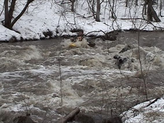
(NOTE: Photo is not of this rapids, but is more intended to represent a common danger that repeatedly besets boaters on this run!)
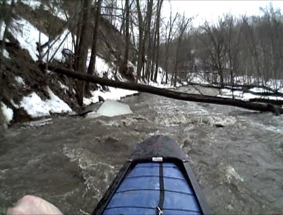
The entire run is through a wooded area. Branches and entire trees regularly drop into the creek. Larger trees may remain rooted on one shore, and lie diagonally across the stream. Smaller trees and branches will be swept downstream to hang somewhere, and then accumulate other branches.
Those doing a carry-up run should check this rapids by walking a little ways off the trail.
Just downstream of a bridge, before the river makes a right-hand bend, a play wave with eddy service allows front surfing.
We recommend take-out at this footbridge.
Downstream you'll encounter lower gradient and (as a result) more deadfall and snags accumulating.
Because of trees blocking the creek (prior to Hwy.169/Sioux Trail), it is recommended to take out well upstream.
If/when those obstructions are gone (by natural or human remedy), boaters could continue to the confluence with the Minnesota River.
Since the majority of the gradient is upstream, it is doubtful how worthwhile the additional distance would be.