Wisconsin
E) Stevens Point: Whiting Dam, Al Tech County Park (PnP, 0.6mi.)
| Difficulty | I-II |
| Length | 5.4 mi |
| Avg Gradient | n/a |
| Gauge | Wisconsin River at Rothschild, Wi |
| Flow Rate as of 58 minutes | 1120 cfslow runnable |
| Reach Info Last Updated | July 14, 2022 |
Bryan Foster provides (2012-05-10):
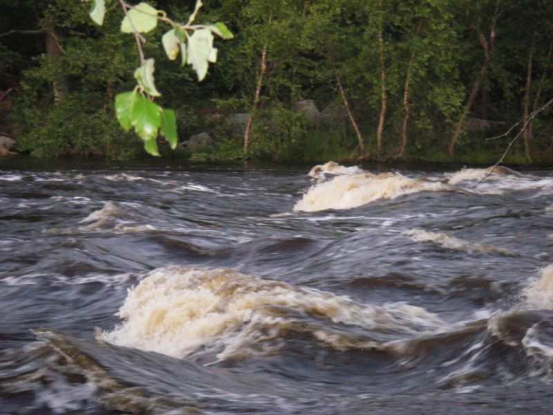
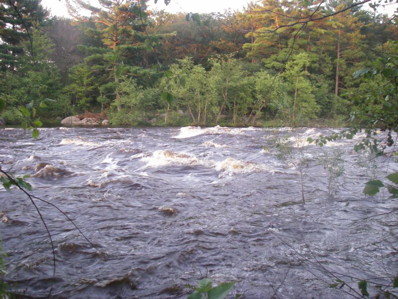
The low head dam in the county park here is very dangerous. Upstream a few hundred yards are some waves that are surfable, with eddy access on river left. You can entertain yourself with some eddy line tricks. There is a small parking area (fisherman's parking) for one or two cars off West River Drive at the waves, but this requires a ferry across a fast flowing and wide Wisconsin River, and just downstream is the low head dam. It does have a route down the right side that is technically runnable.
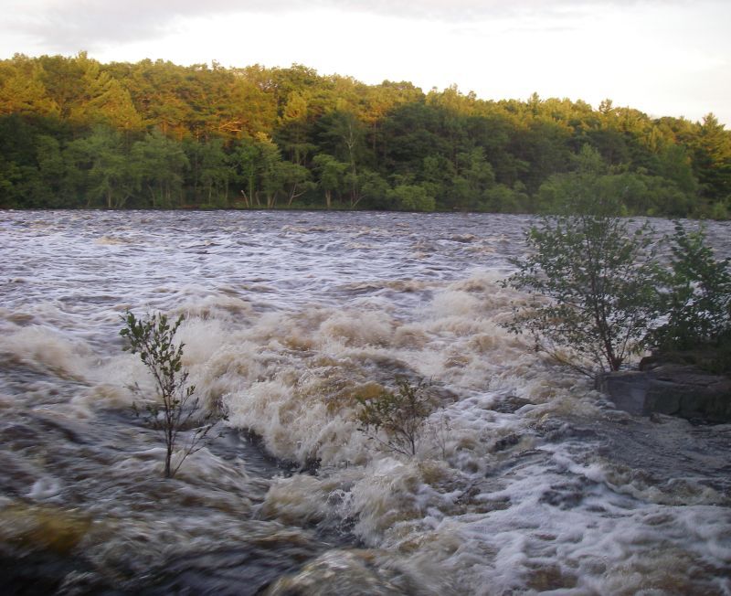
Below the dam/spillway are some class II waves/rapids. I did this when the Wisconsin gauge at Rothschild was at 5590 cfs. (See the pictures uploaded on AW.)
I also have heard a rumor of the center of the low head dam being run (there is a kicker in the middle). I personally think it is not worth the risk to run the kicker or the right side of this dam as it looks to be an excessively dangerous recirculating killer low head dam. (I would even estimate that it had a 4' height differential from the hole to the boil water when I was there.)
The wave was present at a flow of ~4.5 kcfs at the Stevens Point dam via a NOAA gauge:
http://water.weather.gov/ahps2/hydrograph_to_xml.php?gage=stpw3&output=tabular
A user ('pinky79') provided (2012-08-13):
From Al Tech park there are some channels that can be run on the back side of the spillway island. (Looking across the spillway there is an island -- on the back side there is another spillway/channel). Cross the river to follow the left hand shore down stream, go up and around the island and back upstream for a short distance and you will see the back spillway. You can then portage up a trail on the island until you get to a concrete wall (~300yds ). The trail starts at the end of the first small channel. (There is an old orange 'Dam ahead' buoy on shore --
...There may be a few options for put-in.
2697 West River Drive, Stevens Point, WI (this is at the upper dam)
44.48552 -89.57527 (A fisherman's access, river-right, about even with the first playable waves.)
Al Tech County Park (to either carry up or attempt to attain to upper areas?)
Surfable wave(s) with eddy access on river left (possibly good for some eddy line tricks).
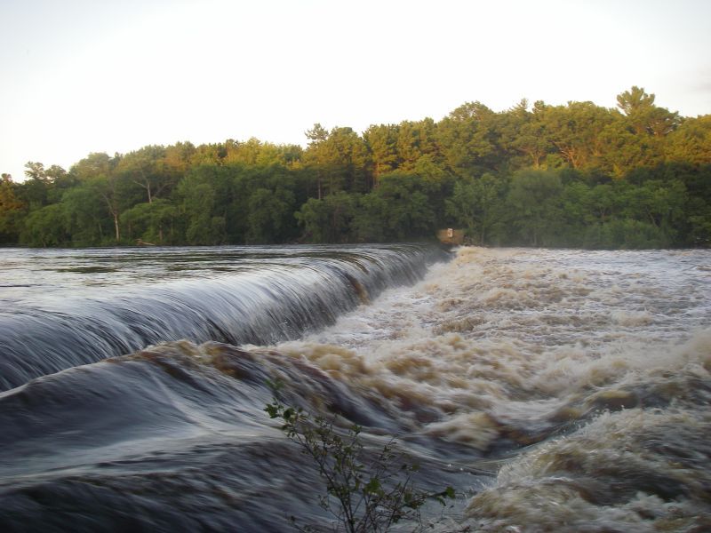
This is a clasic 'killer low head dam'. The drop is fairly small, but the boil-line is strong (inescapable) at most flows.
At some flows, there may be a 'break' in the middle which may be runnable, but there would be very little chance of anyone being able to effect a rescue if you fail to hit the right spot and/or fail to punch through the hydraulic, so think twice (or three times, four times) before thinking about running it.
Again, depending upon flows, there is likely a route down the far-right side that is runnable ... just make sure you are clear of the grasp of the boil line!
The river-right side is runnable at some variety of flows ... just make certain to stay well-away from the boil/recirculation of the dam!
NOTE! MOST islands in this area are privately owned -- by Neenah, Inc.(paper plant on river-left), by the Water Power Co., or by one or more individuals/families!
Most notably, more than half of the largest island (labeled on some maps as 'Fields Island', 250+acres) is held by one family, a smaller portion by another family, and the remainder by a development LLP (limited liability partnership).
There are a small number of islands which are managed by BLM (U.S. Bureau of Land Management), only two of which allow camping ('dispersed camping, 3-night max'). This is the first such island in this area.
NOTE! MOST islands in this area are privately owned -- by Neenah, Inc.(paper plant on river-left), by the Water Power Co., or by one or more individuals/families!
Most notably, more than half of the largest island (labeled on some maps as 'Fields Island', 250+acres) is held by one family, a smaller portion by another family, and the remainder by a development LLP (limited liability partnership).
There are a small number of islands which are managed by BLM (U.S. Bureau of Land Management), only two of which allow camping ('dispersed camping, 3-night max'). This is the second such island in this area.
Jul 26, 2019
The first 1:30 of this video shows this area at very high flows. (There's more video beyond the 1:30 mark, but little of actual merit or interest.)
https://youtu.be/NcfGNRF1Ju8
Mar 24, 2012
The county park is at a low head dam that is very dangerous.
Upstream a few yards are some waves that are surfable with eddy access on river left. You can even thrill yourself with some eddy line tricks. There is a small parking area (fisherman's parking) for 1 or two cars off west river drive at the waves. This of course requires a ferry across a fast flowing and wide wisconsin river in order to get to the waves.
Downstream is the low head dam that does have a path down the right side that is technically a runnable area and some class II waves/rapids below the dam (aka spillway).
I did this back in the summer of 2010 when the wisconsin gauge at Rothschild was at 5590cfs. see the pictures.
I also have heard a rumor of the center of the low head dam being run, as there is a kicker in the middle, I personally think it is not worth the risk to run the kicker or the right side of this dam as it looks to be an excessively dangerous recirculating killer of a low head dam. I would even estimate that it had a 4' height differential from the hole to the boil water when I was there.