| Difficulty | IV |
| Length | 5.8 mi |
| Avg Gradient | 80 fpm |
| Gauge | No. Trinity at Helena |
| Flow Rate as of 16 days | 105 cfsstale data |
| Reach Info Last Updated | February 12, 2025 |
River Description
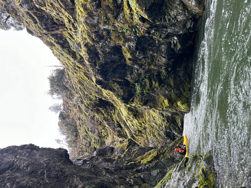
The East Fork North Fork Trinity flows out of the southern Trinity Alps Wilderness Area as a fairly small stream. With drive-up access, this upper run is best when the lower run on the EF NF is flowing well. It's possible to link the two runs for a longer day on the river.
The run starts with a fun warm up section and the river quickly picks up some tributary flows before it enters a series of narrow bedrock micro-canyons. The more significant rapids of the run are in these canyons.
Always be on the lookout for wood blockages. The 2021 Monument Fire burned thorugh this area and even more large wood will be entering the stream and moving as a result. Additionally, cut logs and trees from the firefighting effort now are in the channel and pose risks to boaters. Contact the Shasta-Trinity National Forest at (530) 623-2121 to voice your concerns over the cut wood in the channel.
Even before the fire, one of the rapids in the lower section of this run was given the name Log Death Rapid, and its a mandatory portage. Many boaters have had a close call here because there is not a clear view downstream to the og of death until it is too late and no eddys remain. Be on the lookout for a view of the road on river left, soon followed by a large flat-faced billboard rock. Get out and portage before the rock.
Most paddlers take out at the East Fork Road bridge just downstream of Barney Gulch. Continue downstream to paddle the lower run.
Best Guidebook: The New School Guide to Northern California Whitewater (Dan Menten, 2016), p. 129.
River Features
East Fork Road Bridge
Access PointDistance: 5.81 mi
Take out at the East Fork Road bridge. This is also the put-in for the lower run.
Trip Reports
Log in to add a reportDP
Todd’s cabin! - Darryl Pauline
Jan 27, 2024
Edited December 2024
I have run the Todd's cabin about 8 times and the lower efnf many times. These runs are in my all time favorite list.
I like lots of water on the lower run. There are a couple gauges on the mainstem trinity above and below the next tributary upstream (canyon creek.) Then there is cedar flat gauge some miles below the north trinity confluence. Check if the dam is releasing anything above 350 cfs. The dam releases are all over the place now and not always planned far in advance. If it is releasing, do the subtraction. We ran Todd's cabin in January 2024 at 2000 cfs estimate on the north trinity, and I consider this the best flow. Keep in mind that the north trinity flow reading posted on dreamflows.com is at this time, a rough estimate based on mainstream Trinity gauges and some hocus pocus. The estimate also does not account for dam releases! The east fork north fork trinity is further estimated to be 15% of the north trinity estimate. Looking at the north trinity estimate again, 1000 cfs is too low to be quality but ok for a first time exploration. At 2000 cfs one can run both Todd's and the lower for a 12 mile day. I ran the lower after a December storm this year. The low elevation snow locked it up so that the 2500 cfs estimate was surprisingly not enough to to make it excellent. The estimator gives up over about 3000 cfs. At the higher flows, my roughest estimate is based on cedar flat gauge. 20,000 is too high for either run. 10,000 is good for the lower. Something like 5000 might work for Todd's cabin. The highest that I've run Todd's cabin was cedar flat about 8000 and a north trinity estimate of 4000 cfs, so est 600 on east fork north fork and I was scared, but had a great time.
Scout the upper gorge to see if the Funnel is clogged with wood. It is currently unrunnable because of a big log (dec 2024). About a mile into the run, a few small drops after the left side waterfall, peek downstream from the micro eddies to see a steepening gorge. Scout right from a marginal eddy with a little teamwork and a steep scamper.. The portage rope has frayed away, so it would be good to bring a 50' rope.
I have never understood the 'log death rapid' reference. However, about 3-4 miles into the run, the old road, which is now a trail, becomes visible on the left during a low gradient section. Watch for some small class ii drops that lead into a dangerous rapid. Eddy left above a 2 foot angled ledge. The right drop below is clogged with log. Run the rapid on the left over jagged rocks at the base of a tiny landslide. (Currently this is a mandatory portage dec 2024)
Boogie down another couple miles after the real road starts and you will see a big rock on the left for scout/portage and a car sized rock blocking the view of the right channel. Get out and scout. Boaters do run this rapid.
There is always wood somewhere and frequently there is a mandatory portage as a result.
DP
Todd’s cabin upper efnf trinity - Darryl Pauline
Jan 27, 2024