Rock, E.Br.
(Theresa to) Kekoskee (PnP, or unlikely run up to 13 miles)
| Difficulty | II(IV) |
| Length | 13 mi |
| Avg Gradient | n/a |
| Gauge | South Branch Rock River at Waupun, Wi |
| Flow Rate as of 48 minutes | 9 cfsbelow recommended |
| Reach Info Last Updated | April 21, 2025 |
We do not recommend this entire stretch be considered a whitewater run. Rather, it has a couple of areas with potential for PnP (park-and-play).
That said, numerous listings on AW (not only in the upper Midwest, but also in various other parts of the country) contain miles-and-miles of flatwater, with a few random bits of whitewater. Thus, inclusion of this reach seems in no way out of line!
Flow information
At the Kekoskee Dam, drainage area of the E.Br.Rock River is 183 square miles (per USGS Stream Stats software). There is a gauge on the S.Br.Rock River at Waupun, where drainage area is 63.6 square miles. Thus, flow here could on average be on the order of 2.877 (about 2 and 5/6ths) times flows shown on that gauge. The 'virtual gauge' being used here reflects that calculation. However, expect this calculation/approximation to be misleading (wrong) a lot of the time. The virtual gauge is merely an indicator of times when flows might be adequate to make it worth checking this location for possible play.
NOTE: There is also a gauge on the (main) Rock River (where drainage area is 456 square miles, thus, flow here could on average be on the order of 0.4 (4/10ths) of flows shown on that gauge). However, that gauge is listed as being '1700 ft. upstream of dam, at Horicon.' Since that dam is used to regulate pond height in Horicon Marsh, flows on that gauge will be more affected than the prior mentioned gauge.
A very short weir/dam exists in the Village of Theresa. It is possible that this could provide some entertainment at some flows (undetermined/unknown at present). However, more of the time (at moderate flows) it will be a short drop into a very uniform (difficult to escape) reversal! DO NOT TRY TO RUN OR PLAY THIS FEATURE WHEN REVERSAL IS PRESENT!
On the north side of the river (on Mayville Street), the village owns a lot with a utility building on it which is immediately downstream of this weir/dam. (Each side of that narrow property is private property. Respect the private property lines -- set foot only on the village/utility property!)
On the south side of the river (at the corner of W.Rock River Street and Wisconsin Street), the land inside the bend in the river is also marked as being owned by the village.
(Mostly a waypoint ... however, aerial views show possible increased interest downstream of here ... I.E. virtually no evidence of interest from Theresa to here.)
A dam on N.Main Street (State Highway 67+28) in Mayville has releasable gates (to the right 1/3rd) ramping short and spilling off high to fall onto shallow splashpan. The river-left (2/3rds) of the dam ramps steeply down to the splashpan. Water sheets across about 12 yards before encountering slightly deeper riverbottom.
It is remotely possible that (at some finite flows) there may be some whitewater play in currents in this area. A park on river-right allows parking and access, though the shore at the dam is steep quarried rock. Any location convenient to launch from may make attainment (of any playable feature which might occur here) a bit difficult. Much of the area is shallow, making scrapey conditions for good paddle strokes.
Downstream (from here to the Kekoskee Dam) appears as though it may have some areas of minor shoals, riffles and rips ... at least at some flows. There is 1 mile at 20 FPM, then a mile at 10 FPM, before things peter out into the backwaters of the Kekoskee dam.
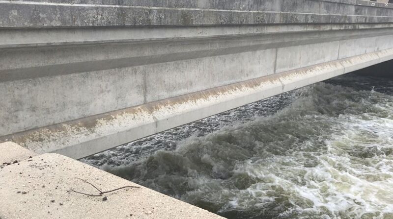
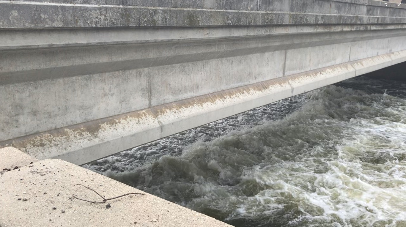
A dam right at CTH.TW (Main Street in 'downtown' Kekoskee) drops about 5-6' onto shallow hardpan and sheets downstream. DO NOT RUN THIS DAM UNDER RISK OF DAMAGE TO BOAT AND BODY! At elevated flows, a wide and sweet-looking wave forms under the highway bridge.
River-left is all private residential property. River-right is D&D Pub Pizza, and is flanked by A Street (not just a street, but 'A' Street!), which heads to Valley Street and a village park.
To do this as a PnP (park-and-play), launch from this park and paddle upstream (if the current and your boating skills allow!). Keep to your left (along river-right shore). As you approach the area of the bridge, water becomes shallow and rocky/grassy/weedy. At low-to-moderate flows, this allows you to 'ape-walk'/muscle-up in your boat to reach the eddy under the bridge. Strong/experienced paddlers playing the wave should be able to come off in control, and should be able to ferry to either shore beneath the bridge for repeat play.
If flows are a bit high or if you fail to be in control coming off the wave, you will likely flush past a point of no return, and will have to once again 'muscle up' the river-right shore. At high flows, it may not be attainable, but then, at such flows you are likely to have trouble staying up under the bridge to repeat play on the wave.