| Difficulty | II-IV |
| Length | 13 mi |
| Avg Gradient | 45 fpm |
| Gauge | Pecos River Near Pecos, Nm |
| Flow Rate as of 59 minutes | 31 cfsbelow recommended |
| Reach Info Last Updated | February 24, 2026 |
River Description
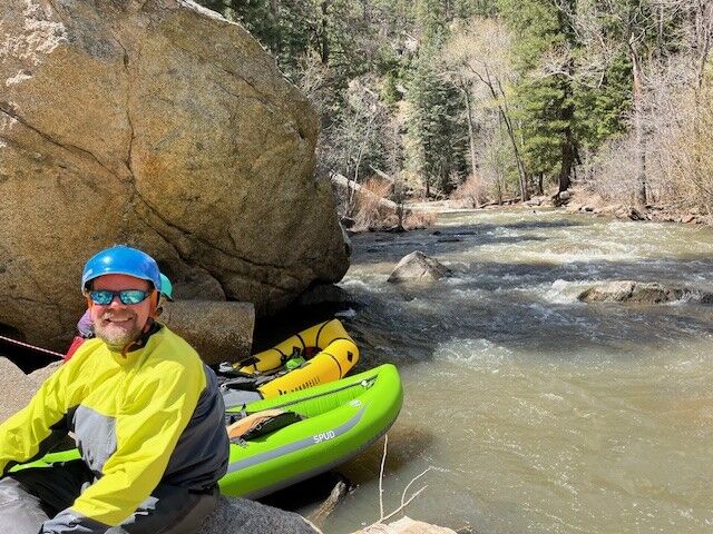
Upper Pecos Paddling is a treat!
Only possible since severe fences have been eliminated in 2024/5. Many public river access areas and facilities, so do not trespass across private land for access. Best to go with one of the Adobe Whitewater Club A-Team few that have multiple runs from the 2025 season. Decent boatable flows would be 170-250 cfs at Pecos gauge. Limited eddies and brushy banks make stopping difficult. Narrow sections limit line choices and wood/snags are ever changing. Some prefer small inflatables vs kayaks and chancing dragging my head in this shallow rocky river. Pecos camping is in established riverside CGs or higher up in forested primitive areas.
There are a number of smaller sections to paddle within this reach.
Cowles to Rio Mora (Gorge) has been paddled, but maybe not since the 80s, so more recon is planned there soon.
Roughly 10.4 miles total from Rio Mora to Dalton.
Rio Mora CG/confluence to Jamie Koche Pavilion (at Terrero Ranch Rd), is a short ¾ mile introduction section with easy access and a few drops. Two compliant hanging PVC fences are easy to negotiate. Two cross-river logs at second PVC fence to be cleared March 2026.
Jamie Koche to Terrero CG is the most difficult cl-III. Remote, shallow and tight with a couple serious features, stay left at “Triple Drop”. First-time scout/portage on river left trail is recommended. This is where we cut out a fallen tree in October 2025.
Terrero CG to Bert Clancy is only ½ mile and more mellow mostly roadside but still some blind corners.
Bert Clancy parking lot for boating and fishing is just below the camping area.
Bert Clancy to Windy Bridge has a high cable just past the cantilever porch and the very dangerous cable at upstream boundary of Tres Lagunas to portage river-right next to a large log. This cable will likely be
...River Features
Cowles putin
Access PointDistance: 0 mi (approx.)

Access is located off of Forest 121 Rd. Proceed west from the intersetion of NM Rt 63 and Forest 121 Rd. The average drop from this putin to the next access is about 90 fpm.
Rio Mora Campground Access
Access PointDistance: 2.76 mi (approx.)
Access to Rio Mora from the campground. You put on the Rio Mora and float into the Pecos.
Rio Mora Day Use Area
OtherDistance: 3.16 mi
Park at day use area along state road 63 to access river
Jamie Koche Pavilion Access
OtherDistance: 4.1 mi
Jamie Koche Pavilion (at Terrero Ranch Rd), is a short ¾ mile from the Rio Mora confluence.
Tererro Campground Access
Access PointDistance: 5.55 mi
Access is located from the north end of the campground. There is day parking for boaters and fishermen. Tererro General Store is located across the river from the access.
Average drop between Tererro and downstream Rt 63 bridge is 63 fpm.
Bert Clancy Campground
OtherDistance: 6.25 mi
Day use area parking at Bert Clancy campground. Fishing and boating access.
Windy Bridge Access
Access PointDistance: 9.41 mi (approx.)
Rt 63 crosses reach at this point thus providing a possible access point.
Upper Dalton Day Use Area
OtherDistance: 13.25 mi
Beach with access too Dalton day use area
Lower Dalton Day Use Area
OtherDistance: 13.3 mi
Beach with access to the lower Dalton day use area
Trip Reports
Log in to add a reportSC
AWC Video - Explore the Upper Pecos River. - Scott Carpenter
Feb 23, 2026
Use link below to view AWC Zoom Presentation recorded Feb 10, 2026, and learn all about Paddling the Upper Pecos River in NM. Many years of effort have re-opened this awesome section to paddling.
And visit our Adobe Whitewater Club website for more!
RS
Rob Smage
Jul 30, 2016
From a user on the StreamTeam Message board:
'We tubed the Pecos from 'NM RT 63 bridge access 3' for about 3 miles at 17cfs, late June. It was really too low but very challenging and exciting, with some logs blocking channels. I'm experienced in white water canoeing.
The website descriptions were helpful but inaccurate regarding barbed wire fences. We crossed about 6 fences in this stretch, any of which would have been extremely hazardous to a kayaker at higher levels.'