Clear Creek
Wilderness Bridge to Slippery View River Access(Upper Clear Creek)
| Difficulty | IV-V |
| Length | 3 mi |
| Avg Gradient | 100 fpm |
| Gauge | Indian C Nr Happy Camp Ca |
| Flow Rate as of 1 hour | 50 cfsbelow recommended |
| Reach Info Last Updated | May 21, 2025 |
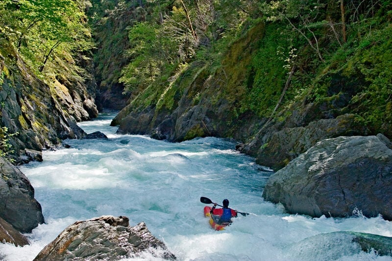
Clear Creek, a pristine tributary of the Klamath, certainly earns its name—its crystal-clear, emerald-tinted water flows through one of the most scenic whitewater canyons in a region known for beautiful rivers. Dropping from the highest reaches of California’s Siskiyou Mountains, the creek forms rapids on bedrock, sculpted boulders, and boulder bars before joining the Klamath about 100 river miles from the Pacific.
There are two commonly paddled sections: Upper Clear Creek (Class IV–V) and Lower Clear Creek (Class II–III). Boaters often link both into a 7.4-mile run. For a more relaxed trip, the lower section can be run alone or extended onto the Class II Klamath River. Upstream lies a rarely paddled wilderness section with variable difficulty.
The three-mile upper run offers outstanding whitewater and scenery. Set in a tight canyon in the Siskiyou Wilderness, the run features greenish metasedimentary bedrock and statuesque boulders beneath a diverse mixed-conifer forest—part of one of North America’s most biodiverse regions.
A one-mile hike on the Clear Creek National Recreation Trail leads to the put-in at the footbridge over the creek.
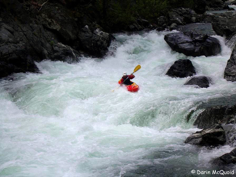
The action begins immediately with a rapid beneath the bridge, followed by a short warm-up section before the creek bears left and drops into the main event. Two ledge-style drops mark the transition. The character is pool-drop, but the pools are short and the rapids plentiful. One or two rapids in the first couple of miles—upstream of the high bridge—are often portaged.
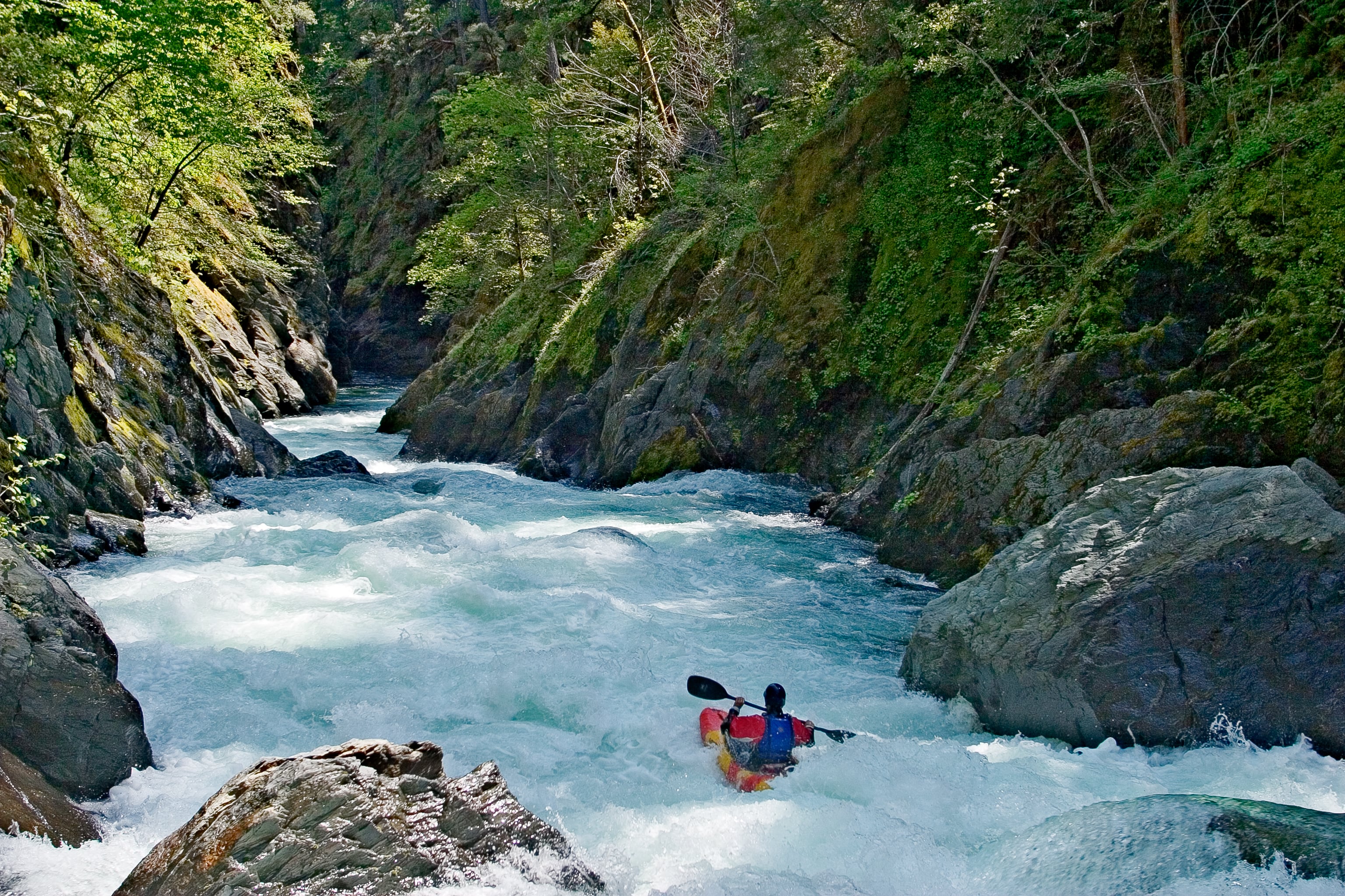
About two miles in, you’ll round a right-hand bend and drop into the smooth-walled gorge visible from the high bridge. This section contains some stout holes and can’t be scouted from river level, so the bridge provides your only good look beforehand.
Just downstream, Fivemile Creek enters on the left. Below that is a m
...After a one mile hike from No Man's Trailhead, you arrive at the hiker's bridge over Clear Creek. It's possible to put in on creek right just upstream of the bridge but its easier to continue across the bridge, take the unmarked path to the left, and put in on the small boulder bar on creek left that's still within view of the bridge. The rapids begin right away and the first half mile is a warm-up for the rest of the run.
Most rapids on Clear Creek don't have names and that's the case for the first rapid which is located right below the bridge at the put-in. A couple smaller ones follow. The first half-mile is all a warm-up for the rest of the run.
A longer warm-up drop with options for some technical maenuvering.
This unnamed class III rapid is the prelude to the bigger drops that start immediately below and marks the entry to the gorge that the creek flows through for the remainder of the run.
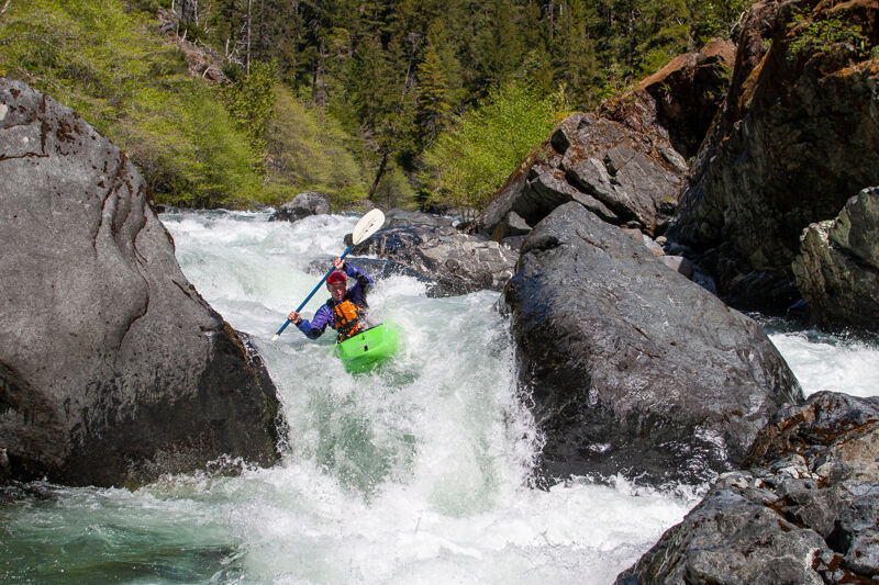
The first of the bigger rapids. There's a four-foot ledge drop on river right. Theis drops you into a diagonal current that wants to send you over to the far left where there's a detention pocket eddy against a rock wall To avoid this, drive hard to keep middle.
There's an alternate line for the rapid on the left side of the large rock splitting the creek.
Usually scouted on the right.
A second, smaller ledge drop with a bouldery runout closely follows the first ledge drop. Usually run down the right.
This is a long rapid with a lefthand entryway that's technical at lower flows and pushy at higher flows. Move right through the entry to avoid the boily pocket and undercut rock on the left. Launch the lip of the drop at the bottom to clear the hole, which can get big at high water.
This is a good one to scout from the left.
The one-mile hike to the put-in on the Clear Creek National Scenic Trail starts at No Man's Trailhead. There is no creek access here.
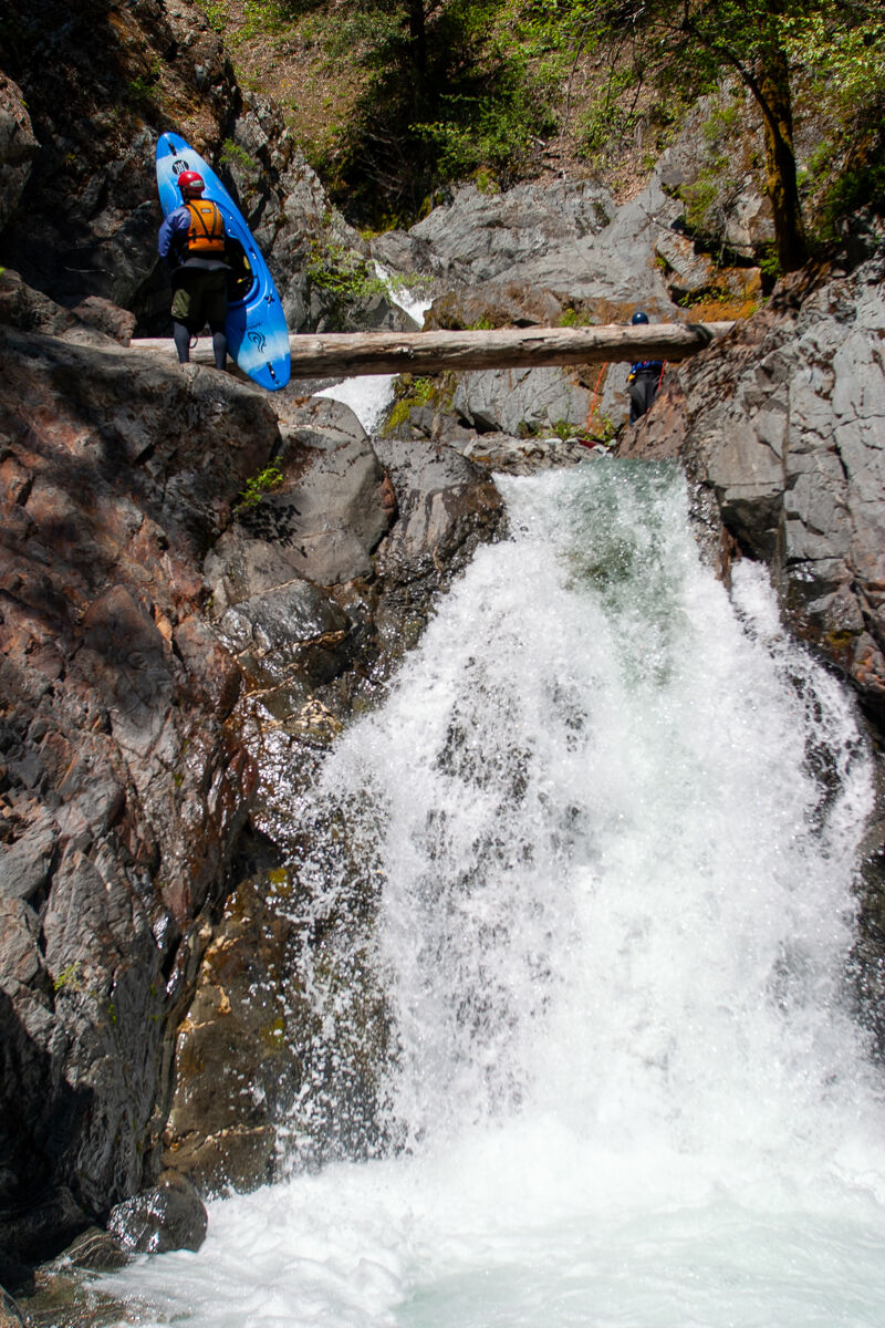
This is a nasty undercut drop with a terminal hydraulic and is a mandatory portage.
As soon as you pass under the high bridge over the creek be alert as the portage is exactly 1/4 mile downstream. Keep an active watch for Fivemile Creek on the left. It enters Clear Creek with a 10-foot waterfall. The eddy for the portage is on the right side of Clear Creek immediately after this.
The eddy is small and will hold two kayaks at best during low flows and only one kayak in medium or high flows. Stagger eddy entries so you don't have a frantic pileup here. The current is swift and the lip of the drop is immediately below. Stepping out of your boat can be sketch here as the bare bedrock can be sick, the water is deep, and the eddy is small.
Complete the portage around the nasty part of the drop on the right and seal launch back into the champagne bubble water in the run out of the drop. Several fun rapids follow immediately and then you'll arrive at the horizon line for Cottonmouth, the last large rapid of Upper Clear Creek.
Cottonmouth is a long rapid that cannot be fully scouted and that also can't be portaged. It's named for the dry mouth you'll get when you realize you can't see all of the big holes in the drop and that you also can't portage due to vertical canyon walls. Scout what you can from the top, stay upright, and punch the big holes you can't quite see in the middle and bottom. There's a long, slow pool at the bottom. Slippery View River Access is a couple minute paddle out from the bottom of Cottonmouth.
Slippery View is a river access site on creek left a short distance below Cottonmouth, the rapid on the Upper Clear Creek Run. The river access is signed along the 15N32 road but it is unmarked at river level and easy to paddle past if you do not recognize it. For this reason, you should scout the take-out from river level before paddling the run. A steep, loose trail goes from the road to the creek.
Jan 1, 2008
The pictured log is now gone. At higher flows it's impossible to get out in this gorge. Ben running the most often portaged runable rapid on Clear Creek, it ends in a sieve with a few exit slots. The largest mandatory rapid on Clear Creek, this one changed in 06/07 and the line is now left, center, right at high flows or center, center, center at low flows. Jon at the bottom of the often portaged rapid. One of the first rapids. the fun top of the often portaged rapid.
Apr 24, 2004
Bluebird day of boating both the upper and lower runs at a medium flow. Perhaps we did the first descent of the falls on Five Mile Creek, which comes into Clear Creek on rive left immediately above Egatrop (the portage). We simply carried our boats up to the top of the falls from the pool at the bottom.