Tyger, South
Route 86 to Route 113
| Difficulty | II-III |
| Length | 9.8 mi |
| Avg Gradient | n/a |
| Gauge | Tyger River Near Delta, Sc |
| Flow Rate as of 154 days | 4.19 ftstale data |
| Reach Info Last Updated | September 26, 2024 |
Instructions to the Put-In
Take Exit 35 (Woodruff & Walnut Grove) from I-26. This exit is between Clinton and Spartanburg. This will put you on the S J Workman Highway (Highway 50). Turn whichever direction and go to the CitGo station. From the main sign at the CitGo station, head West toward Woodruff along the S J Workman Highway. Go 0.2 miles and turn right on Price House Road (Highway 86) (the turn is just past the Kingdom Hall of Jehovah's Witnesses). At 1.5 miles, you will cross Ferguson Creek that feeds into the South Tyger which can be seen to the right. At 2.7 miles, you will cross the South Tyger at Price Bridge.It looks like you could launch at either place. Have not run this reach yet.
Instructions to the Take-Out
Go about 1.6 miles from the Ferguson Creek Crossing or 0.4 miles form the South Tyger crossing to a stop sign at the intersection with Hobbysville Road (SC Road # S42-229). Turn right. Continue down Hobbysville Road. At 0.7 miles, bear left onto Morris Bridge Road (South Carolina Road # S 42-231). At 0.9 miles from stop sign at the intersection with Hobbysville Road you will cross I-20 and at 1.1 miles you will reach the put-in for the Route 231 to Route 113 reach of the North Tyger. Continue 1.1 miles from the North Tyger put-in until you reach Hatchett Road. Turn right on Hatchett Road and go 2.3 miles until you reach Walnut Grove Road (S 42-50). Turn right and go .8 miles until Old Hlls Bridge Road.* After about 1 mile, go right following Road 113. The take out is another 2.1 miles.
\* If you continue on Walnut Grove Road for 2.4 miles, you will cross the Tyger on Highway 50. You can see a lot of the rapids here. There are also very visible and unfriendly n
...Mar 1, 2021
I did the South Tyger from Price House Road to Walnut Grove Road Feb 27, 2021. The gauge reading was around 8’ 4” after a good rain event the previous day. It was a PFD for me and since I didn’t connect with anyone, I did it solo using my bike for the shuttle.
The section from Price House Road bridge to Ferguson Creek took an hour+ and had no rapids. But it did have plenty of wood hazards! Note: the Ferguson Creek access to the river was posted with no trespassing signs so it wasn’t an put-in option for me. Altogether it was almost two hours before I got to the first rapid, which was well past the I-26 bridge. It was a fun, easy Class II-III and a welcomed relief from all the flat water.
The second rapid, a good distance later, was a fun Class II with a nice surf wave.
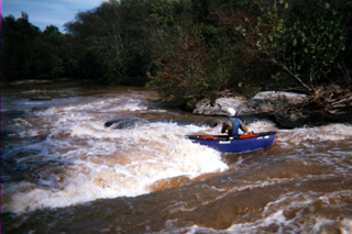
The third rapid was a bit of an unexpected monster. Probably 12 to 15 feet overall drop with remains from an old dam on the right. I ran a small, top drop on the right and ducked into an eddy to try to see the rest of the rapid, but it was too steep. After a bank scout, I ran the main channel right to left avoiding a huge hole in the top center and large boulders further down in the center, right.
A little while later I was at the confluence with the North Tiger then at the ledges (“Nesbit Shoals”) going down to the bridge - these are a lot of fun to read/run, and catch a little surf action on the way.
The huge, main problem with the South Tyger is the length of wood choked flat water before any whitewater action. At one point I needed to portage to do a blockage around a dangerous blockage with Class A/B current going through it. The portage wasn’t easy with 8’ to 10’ high, steep clay banks. If another put-in could be found, downstream from the I-26 bridge, those three rapids plus the ledges at the bridge would make for a nice run.
Sep 13, 2003
Ill try this again. This was rather surprising run for me as I didn't expect much whitewater and expected much less trees and 'isolation'. This run had some 'challenging' whitewater (-4') with some relaxing flatwater surrounding by woods and surprizingly not much development (yet). The rapid below the first bridge had some steel to watch for and I would suggest running river right to avoid it. At this low level it was easy to see but at a higher level it probably disappeards. It is all the way accross the river and is some bolts that are in the rocks so watch out.