Guadalupe
3. Farm Road 3351 to Rebecca Creek Crossing

| Difficulty | II |
| Length | 22.6 mi |
| Avg Gradient | 6 fpm |
| Gauge | Guadalupe Rv Nr Spring Branch, Tx |
| Flow Rate as of 35 minutes | 3680 cfsmedium runnable |
| Reach Info Last Updated | April 10, 2024 |
The Upper Guadalupe is a relatively beginner-friendly stretch of river popular with canoeists and recreational kayakers looking to paddle in a more secluded setting, free of the wall-to-wall tubers and private homes that adorn the Lower Guadalupe. Except in runoff events, during which the river can be very silty, it is usually fed by spring flow and thus runs clean. Except during extreme droughts, the Upper Guadalupe generally maintains a reasonable base flow.
The Upper Guad does not have a lot of gradient, so there are only a handful of named rapids on this entire 25-mile stretch of river. Rapids are typically short and are separated by pools sometimes miles long. Thus, whitewater boaters tend to avoid the Upper Guad unless it is flowing thousands of cfs, and they tend to prefer the stretch below U.S. 281, because it has the largest rapids (including Mueller Falls and Rust Falls) and the least flat water.
With the exception of the afore-mentioned falls, most of the rapids are basic Class I-II rock gardens with little consequence.
The most popular day trips are from Bergheim (FM 3351) to Guadalupe River State Park (7.8 miles) and from Nichol's Landing to Rebecca Creek Rd. (9.8 miles, often shortened to 6 miles by putting in at U.S. 281.) The latter stretch has been designated a Texas Paddling Trail by the Texas Parks & Wildlife Dept.
For more information, see Texas Whitewater, 2nd Edition.
Distances and gradient measured using GIS tools in 2015.

Public access is at river left (north of the bridge) on the downstream side via a dirt/gravel road that runs along the highway easement. Paddlers can also pay to park and put in at Bergheim Campground. The campground also rents canoes and kayaks and runs shuttles for an additional fee.
This low-water crossing can become clogged wtih debris, and at least one person has drowned by becoming trapped in debris under the crossing. There is no real parking here.
Public access at river right with a paved parking lot and bathroom facilities. Camping is also available in the state park (do not camp along the river.) Day use fee or State Parks Pass required to put in/take out.
Historical footnote: David Bamberger, former CEO of Church's Fried Chicken, owned the primary tract of land that became Guadalupe River State Park. In the early 70s, he agreed to sell the land to the state at a price significantly below market value, because he recognized the need for public river access along the Upper Guadalupe. Bamberger is also a conservation pioneer, and his ranch (Selah Bamberger Ranch) at the headwaters of Miller Creek serves as a model for both wildlife and groundwater (spring) conservation in the Texas Hill Country.
Known to be runnable at higher flows, but portage if it looks the least bit sketchy.
River constricts and creates a decent wave train at high flows.
No access at the bridge, but public access is available just downstream at Nichol's Landing.
Public access and parking is available at river left (at the end of Old Spring Branch Rd.) This is a popular put-in for doing a longer day trip down to Rebecca Creek Rd. The relatively flat stretch of river from Nichol's Landing to U.S. 281 is also popular with tubers during the summer.
Southwest Paddler warns that vehicles parked here after dark will be towed, but it is unknown whether that beta is current.
No public access, but you can pay one of the river outfitters.
Wave train at river right during high flows
Not a very good access point. Requires parking along the highway and hiking up/down a fairly steep hill to get to the river.
At low flows, Mueller is typical run river right, requiring a slight S-turn maneuver through the trees. At around 700-800 cfs, the main ledge at the center of the river becomes runnable. At higher flows, a few areas of the ledge hole can be a bit grabby.
An island creates a small Class II channel at river left that is generally unconsequential, but sometimes fallen trees can create a hazard on this channel-- always scout before running it. The island is a popular lunch stop for day trips.
Rust Falls is formed by a V-shaped limestone ledge. The typical line is far river right, down a couple of stair steps that angle toward the center of the river. At higher flows (generally 700-800 cfs and higher), a straightforward Class II sneak line opens up at river left. The center line (V-notch) can take on more of a Class III- character, particularly at higher flows. Water from both sides of the falls runs into the notch, creating tricky cross currents and eddy lines. The current coming in from the right is typically stronger, so be prepared to brace on that side. The hole formed by the notch itself is generally unconsequential. If a kayak without a paddler flushes into it, the boat may stay there for a few seconds, but it will be flushed out quickly. Boats with any forward momentum at all should punch right through. Note, however, that there is at least one known incident of an inexperienced whitewater kayaker getting a playboat stuck sideways in the V-notch at low flow (300-400 cfs) as the result of a failed boof.
The river splits into multiple channels around a couple of small islands. Be extra vigilant if running the far left or right channels, as these can sometimes become blocked with fallen trees and other debris.
A new high bridge was completed in 2013, with a paved takeout area at river left on the upstream side. You can temporarily park your vehicle here while taking out, but do not leave it here. Instead, park it in the gravel along the downriver side of Rebecca Creek Rd. about 150 yards up the hill from the takeout.
Just downstream of the bridge is a Class II rapid that forms a nice wave train at higher flows (> 1000 cfs.) This is the last rapid before the river flows into Canyon Lake.
Apr 4, 2005
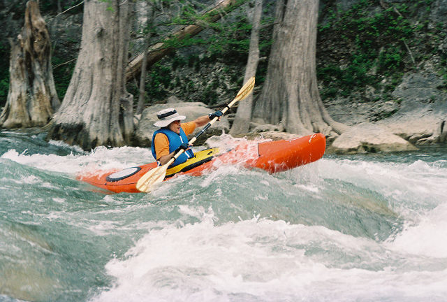
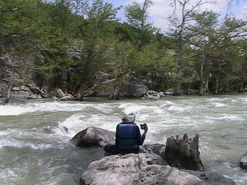
The best rapid we experienced that day, Rock Pile Rapid is located 1 mile downstream from our put in, FM3351. I had the pleasure of borrowing the photographer’s kayak, a Dagger Blackwater 10.5 (skeg up!) for this shot. The half-day 8 mile adventure took us to the take out, Guadalupe State Park.
Jul 20, 2004
The trip was wonderfull from Farm Road 3351 to Rebecca Creek Crossing.It was about an 8 hour trip at 1000cfs. Some nice little sets of rapids. great for sit-on-top kayaks and some skill. Go before 2:30pm or you will be in the dark and have get around the last fall before the bridge. I wish i could have went off it, but was to dark to see anything.
Apr 15, 2002
Paddled the Guadalupe at ~200 cfs from Guadalupe River State Park down to the takeout at the Rebecca Creek bridge. This level is a little on the low side, and makes for some long slow stretches that can wear out the shoulders. Still, had fun on maybe four sets of rapids. Our Keowee III's low sides flooded us while driving over the horseshoe at Rust Falls. A good family float river with lots of places to swim.