| Difficulty | I-II |
| Length | 27.5 mi |
| Avg Gradient | 13 fpm |
| Gauge | Medina Rv at Bandera, Tx |
| Flow Rate as of 1 hour | 4370 cfsmedium runnable |
| Reach Info Last Updated | July 11, 2015 |
River Description
Mostly a scenic float trip with multiple put-in/takeout options. Numerous low-water crossings exist along the run, and Texas Whitewater implies that at least most of these are runnable at high water, but all low-water crossings are potential hazards. Exercise extreme caution around them. Current beta is needed regarding the location of specific rapids along this stretch.
Distances and gradient measured using GIS tools in 2015.
River Features
Coalkiln Rd (Low-Water Crossing)
HazardDistance: 5.07 mi
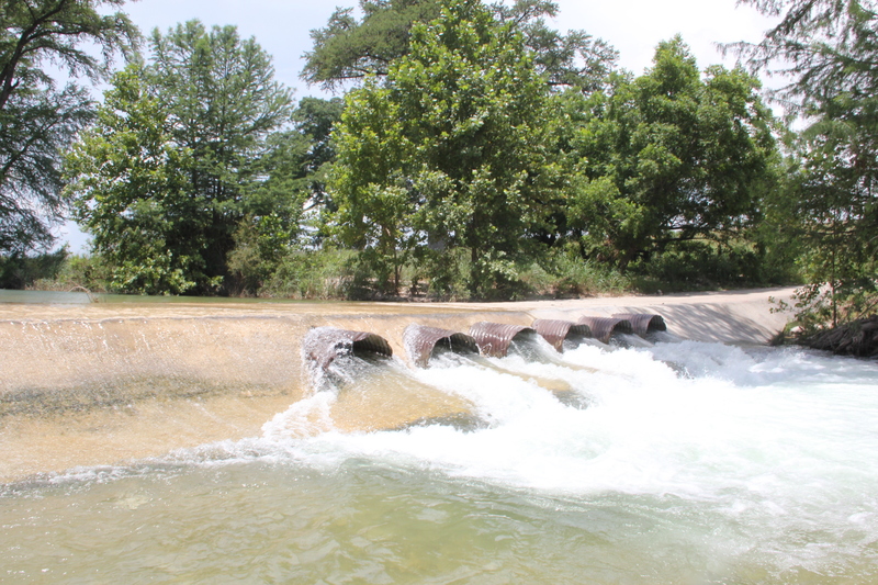
Possible hazard.
(NOTE:photo is merely representative of most of these low-water crossings, and is not necessarily this specific crossing.)
Patterson Ave/Flower Moffett Rd (Low-Water Crossing)
Access PointHazardDistance: 7.3 mi

Hazard at certain water levels. Public/access parking at river right, upstream of the crossing (Moffett Park)
Chenaults Ln (Private Low-Water Crossing)
HazardDistance: 10.22 mi
Possible hazard. This low water crossing is a hazard and should be portaged. I crossed it the somewhere around 600 cfs there are 3 or culverts under the road crossing, on the river left side. the river right side creates a nasty hydralic (large boil line) as the water goes over the road. Be sure to portage if water is greater than 500 cfs. Large tree down shortly after the crossing. Mandatory porage due to strainer after crossing. With in a couple hundred yards.
Bandina Ranch Rd (Low-Water Crossing)
Access PointHazardDistance: 13.92 mi
Possible hazard. Limited parking along SH 16 easement at river right.
Peaceful Valley Rd (Low-Water Crossing)
Access PointHazardDistance: 17.38 mi
Possible hazard
SH 16 Bridge (Ranger Crossing)
Access PointDistance: 21.2 mi
Public parking/access via a picnic area at river right, upstream of the bridge
FM 470 Bridge (Tarpley Crossing)
Access PointDistance: 21.8 mi
Public parking/access via a picnic area at river right, downstream of the bridge
6th St/Schmidtke Rd (Low Bridge)
Access PointHazardDistance: 25.26 mi
Likely hazard at some levels
1st St/Rugh Hill Rd (Low Bridge)
Access PointHazardDistance: 26.22 mi
Possible hazard at certain water levels
Bandera City Park
Access PointDistance: 27.12 mi
Public access/parking at river left, upstream of the SH 173/Main St bridge
Trip Reports
Log in to add a reportNo trip reports yet.