Chehalis
1 - West Fork to Pe Ell
| Difficulty | III-IV |
| Length | 13.8 mi |
| Avg Gradient | 42 fpm |
| Gauge | Chehalis River Near Doty, Wa |
| Flow Rate as of 1 hour | 64 cfsbelow recommended |
| Reach Info Last Updated | March 22, 2026 |
The Chehalis is a little off the beaten path as one of the few whitewater runs in the southwest corner of the state, but it serves up some great whitewater for a wide range of interests. River cruisers who want to get in a good workout can enjoy up to 15 miles of continuous whitewater, intermediate paddlers can find several fun sections with only a couple portages, experts can find a couple very challenging drops, and playboaters can find several fun features. Although the run is plenty of fun at lower levels the middle section moves a little slowly for some. The big drops provide added excitement at higher flows and this run has long been known as a place to check out after a good heavy rain. The scenery on the run can best be described as working forest, with clearcuts dominating the landscape. Despite that the geology is striking and with new riparian forest protection guidelines for the benefit of salmon, the forest along the river is recovering.
The run can be divided into six sections marked by the bridges that cross the river. The river forms at the confluence of the west and east forks, and from this point to the first bridge downstream the river flows at a lazy pace through continuous class II rapids. Unless you are paddling down from the East or West Fork or otherwise looking to add miles to your trip you might want to consider a put-in at the next bridge downstream (mile 9.1 bridge).
With the start of the second section the pace picks up with several class III ledge drops and fairly continuous action. The road will be to river right and closely follows the river here and the section ends as it crosses back to river left (mile 6.9 bridge).
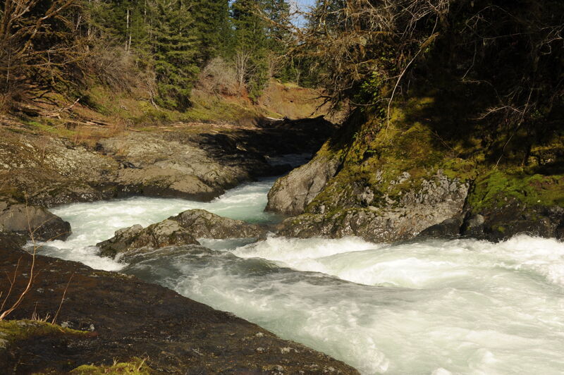
Although the third section starts slowly you will recognize a change in the charcter of the river as you enter the first significant class III+ drop on the run. There are a couple great rapids before you reach the approach to Cape Horn and the entrance to the first gorge. This rapid, also known as Fi
...
In Feb 2009 Lewis County PUD released a draft study for a water retention facility and hydropower project with a reservoir that would innundate a 9.6 mile portion of this run approximately to this point. Located at USGS river mile 117.9 mile. Various iterations of this proposed dam have continued to persist with more recent proposals considering an inundation zone that is downstream of this point.
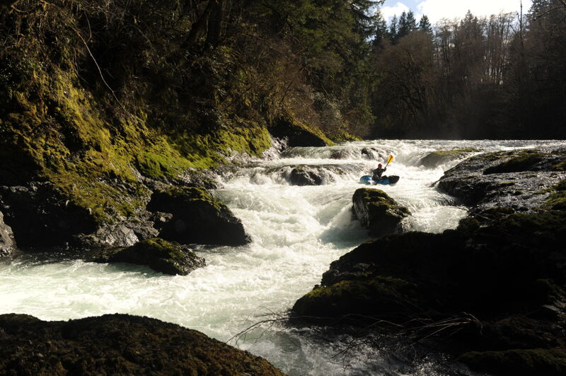
This is a fun sequence of whitewater through a short gorge that is a distinct set of features at lower flows and a wild ride through powerful hyraulics at higher flows. It's an easy scout from the bedrock shelf on river left but don't over commit to the rapid before you are in a position to get out and take a look. The character changes considerably with flow. Located at USGS river mile 113.5.
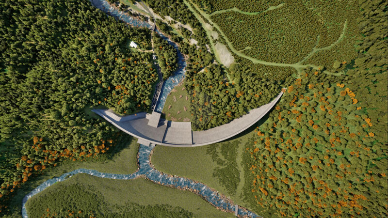
In Feb 2009 Lewis County PUD released a draft study for a flood control dam and hydropower project that would innundate a 9.6 mile portion of this run. Various iterations of this proposed dam have continued to persist. The latest proposal is for a flood control dam with an outlet works at the base so the reservoir would fill during high water events and then slowly drain and allow the river to flow through the base of the dam during low water. The dam would be 270' high and 1550' long with an inundation zone extending 6.5 miles upstream. The facility would cause significant, unavoidable impacts to fish habitat, including inhibiting spring Chinook and steelhead trout, and would result in the permanent loss of recreational river access.
The first rapid that starts of the lower gorge, a great section of whitewater on the Chehalis River.
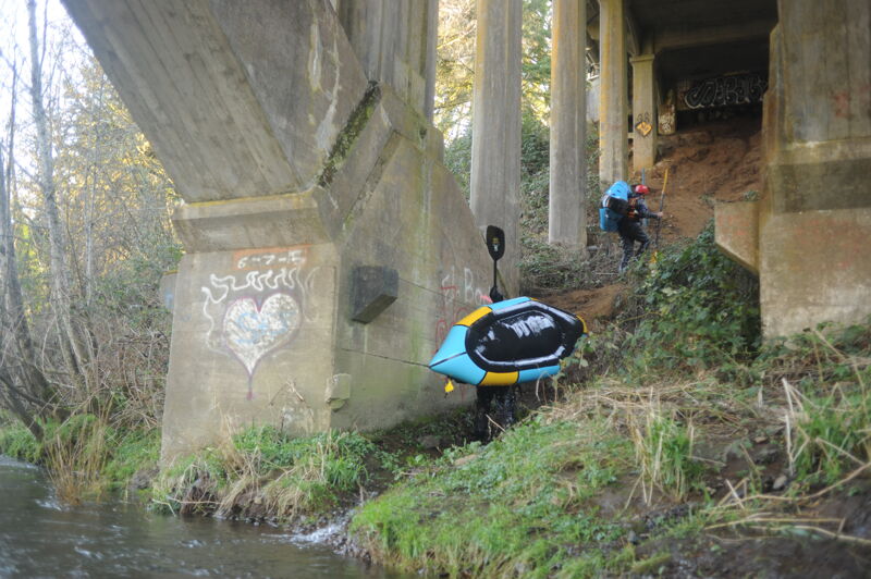
The Highway 6 bridges is located a mile marker 28. The access is a steep and muddy trail that begins on the upstream river left side of the bridge and continues to the water's end under the bridge.
Mar 21, 2026
Normally the gate to the Chehalis River watershed is closed, but on this day we were on an escorted tour to learn about the proposed Chehalis River dam, and the flows happened to be ideal for boating. Why not get dropped off and take the opportunity to tour the proposed dam and reservoir site by packraft? Our tour guides obliged, and we had a wonderful trip.
After a stop at the dam site and a discussion of the project with colleagues from the Chehalis River Alliance, we were on the water at approximately 2:30 in the afternoon on a beautiful sunny day with optimal flows—a rarity on the Chehalis.
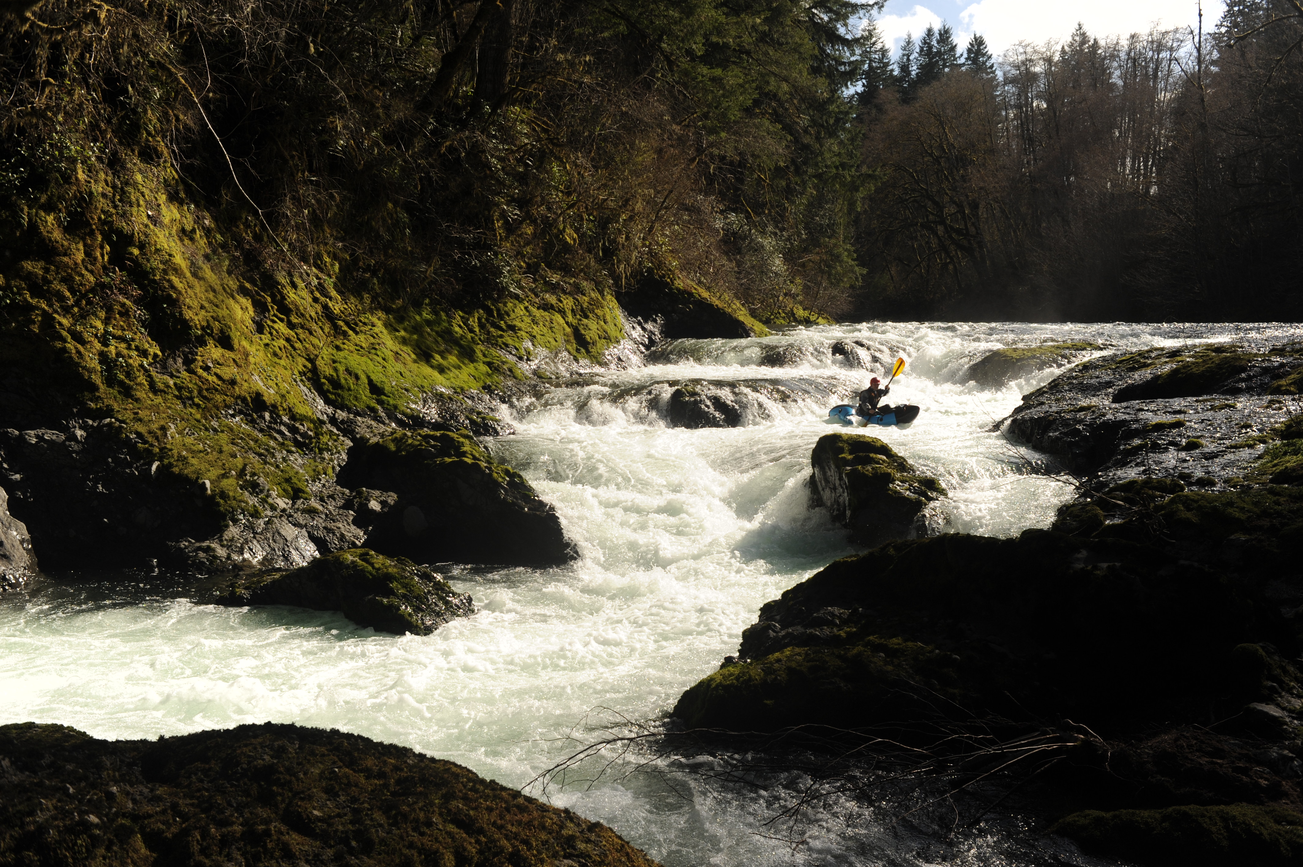
We followed the mainline to a point a couple miles upstream of Fisk Falls and enjoyed several fun Class II+ rapids over approximately 40 minutes of paddling down to Fisk Falls. We took out above the falls and scouted from the bedrock shelf on river left. After a thorough scout, Nick and I decided to give it a go. The opening sequence went smoothly, starting far right and then moving across the center to finish far left—a line that avoided the biggest hydraulics. Following this opening drop, the river narrows into a slot against the bedrock wall on river right. I encountered a deceptively sticky hydraulic in this section but managed to work my way out after about four attempts. Had I flipped, I don't think it would have been possible to get out without assistance from a rope. We enjoyed one final pitch before reaching the calm water below and passing under the bridge.
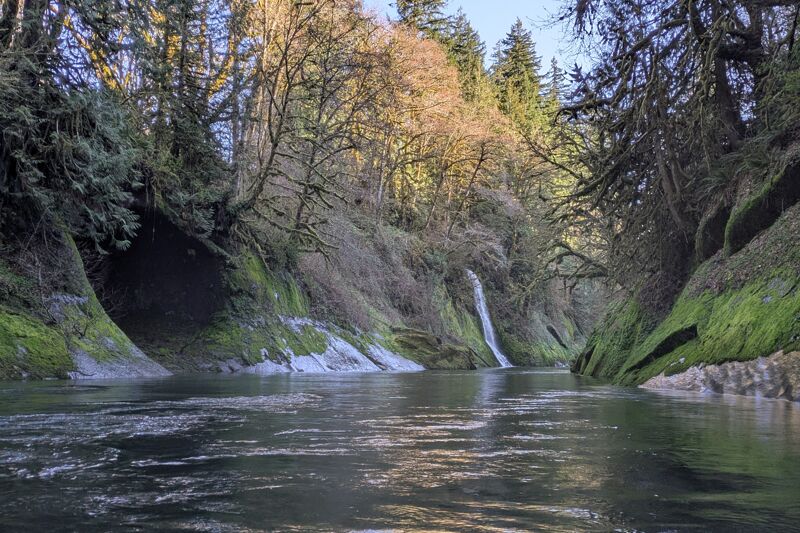
It was a lovely float from Fisk Falls down to the confluence of Crim Creek, which enters on river left near the area of the proposed dam site on the Panesko Tree Farm, located within surrounding Weyerhaeuser forest lands. This section has several Class II rapids and some surf waves. While the riparian buffer seems a little narrow in spots, the river corridor is lovely and offers a view quite different from that experienced on a driving tour of the watershed. A mix of conifers and deciduous trees lines the shoreline, the water was exceptionally clear, and ideal spawning gravel was dispersed across the riverbed. Having spent time along many sections of the Chehalis River, this upper reach clearly has some of the highest-quality habitat. The dam, even if the reservoir is allowed to drain as is currently proposed, would have a devastating impact on the landscape.
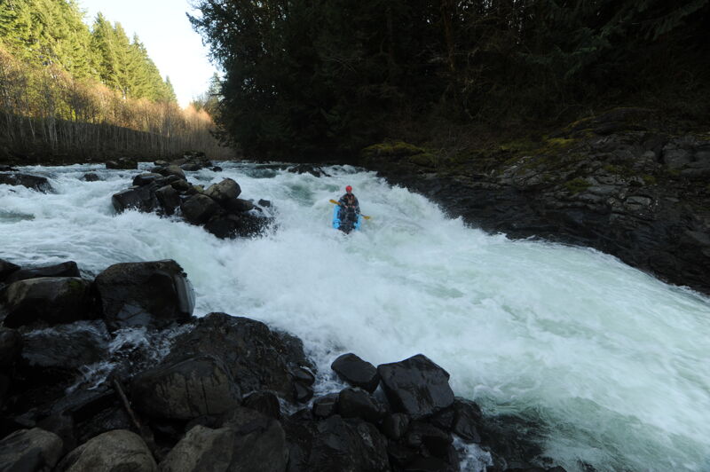
Continuing past Crim Creek, the gradient picks up, with an obvious horizon line marking one of the bigger drops on the run, located near the proposed dam construction site. Nick fired it up with a clean line down the right side of the main river left channel. Below here, the river enters a beautiful gorge with some great Class IV whitewater. We passed under the new bridge (which replaced the covered bridge washed away in the 2007 floods) and enjoyed several great rapids over the next quarter mile or so. While a couple had slightly intimidating horizon lines, we were able to find the lines by boat scouting. When the gradient finally tapered off, we passed through the tranquil waters of another beautiful gorge.
We reached our take-out at the Highway 6 bridge on river left in Pe Ell at approximately 6:00 p.m. It was a bit of a muddy scramble up the bank. We then walked back to our cars, which were parked at the Pe Ell trailhead where we had met earlier in the afternoon. It was a great trip, and I hope more people get the chance to experience this river.
Mar 21, 2026
Wow. I feel so fortunate to have finally got the opportunity to paddle the Upper Chehalis. Locked away behind Weyerhauser gates, this run is difficult to gain access to. If you get the opportunity to explore it, take it. This river and its geology feels unique amongst Washington runs. While generally not gorged in, bedrock is nearly always within sight. This makes for lots of fun little ledge waves prime for surfing. The run has a mix of meandering class II-III, a couple impressive class IV+ sequences, and a few exciting class IV- drops. A stunning mossy gorge at the end completes the experience. This run leaves me wanting to explore more of the upper reaches of the Chehalis and other Willapa Hills runs.
Tom, Ariel, and I hit the river in the afternoon after attending a tour of the proposed dam site that would destroy this run. Thanks to all that organized and attended the tour! Weather was cool & sunny, flows were a medium low 1000cfs on the Chehalis @ Doty gauge. We put in a bit below mile 6.9 bridge where the road was closed.
Put in: 46.47932, -123.29548
The next couple miles were pretty floating with a dozen or so fun little class II-III rapids with some chill surf waves. As we approached fisk falls, we floated river left over a long bedrock shelf submerged under 8 inches of water. We hopped out of our boats and walked onto the bank to scout / portage. Tom and I walked back upstream to run the first portion of the falls and then eddied out to regroup. Tom sent the last drop and immediately got sucked back into the recirc. He had to fight hard to break free. Knowing what I know now about how sticky that last drop is, I don't think I would run the falls. If anyone was, I'd definitely set safety above and below that final drop.
Fisk Falls: 46.50227, -123.29008
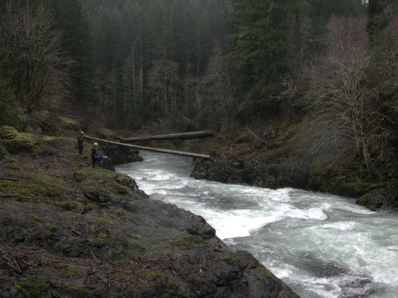
After another few miles of scenic floating and some fun little whitewater, we approached the next big drop above the old covered bridge that was washed away in 2007. We parked our boats on river right and worked our way down the bank to scout. This drop may have changed a bit since the AW description was written. It had a nasty pocket hole extending from the left bank wall that you would want to avoid at all cost. I would recommend a scout.
Covered bridge rapid: 46.54412, -123.29727
After covered bridge rapid, we passed through a pretty little gorge. Not much later were a few really fun class IV drops, the last of which tripped me up and sent me for a quick refreshing dunk. Around this time, the canyon walls started to close in to form a proper bedrock gorge covered in moss. Absolutely stunning.
As the canyon walls opened up again, we came upon highway 6 and took out on river left under the bridge. A short walk through town and we were back to our cars at the Willapa Hills Trailhead.
Trailhead parking: 46.56943, -123.29686
Mar 31, 2024
Myself and a friend drove to the 'put in' to find the gate closed to the Mcdonald tree farm as of 3/30/24. We knew this was a risk, so we put our packrafts into our backpacks and started walking. We walked around 11 miles and ended up putting in at the confluence of the east and west fork. If a car could get through the gate, it could get to the confluence. We did see other a few other cars driving behind the gate, so keys / access certainly exists, not sure how one can go about getting one as a private individual (if it is possible at all) through Weyerhauser. As you walk (or drive) you can see the majority of the run through the trips as you drive near the river for a lot of the run. The flow was on the low side but definitely floatable. The majority of the run is class II (or II+) except for two notable rapids which were in the IV range. The first is fisk falls, around halfway through the run and is marked on american whitewater at the correct location. Scout left, portage left if you desire. The second is just before the locked gate around 'charlie's hump'. Scout right, portage right if you desire. This rapid continues downstream, but we had a nasty flip on 'charlie's hump' and did not want to walk any further, so we took out at the last bridge just before the locked gate. There was no wood on the entire run. There was a good amount of metal on the side of the river to watch out for, hard to say how much might be underneath the surface.
Dec 2, 2012
Access to this run is still closed as of 12-2-2012. There are road washouts and locked gates within .5 mile of the McDonald Tree Farm entrance. A large Weyerhauser facility there might be able to provide access info by phone. Be friendly if you try.
Jan 31, 2004
It was a cold, wet, and rainy day on the Chehalis River with the water on the rise. None of us had ever been so we decided on a long trip begininng on the West Fork and continuing on down to the Highway 6 Bridge in the town of Pe Ell. The water was high but it still felt within the range that was fun and manageable.