Kalama
1. Upper Kalama Falls to Gobar Creek(Upper Kalama)
| Difficulty | III-IV |
| Length | 17 mi |
| Avg Gradient | n/a |
| Reach Info Last Updated | April 21, 2026 |
Projects
Washington’s legendary volcanoes – Mount Rainier, Mount St. Helens, and Mount Adams – are the source of wild, free-flowing rivers and streams that cascade over big drops and through deep basalt canyons on their way to the Columbia River. Rivers like the Clear Fork of the Cowlitz, Cispus, Green, [...]Read More
River Description
This section is behind the Weyerhauser gate, and only accessible for those who pay for permits.
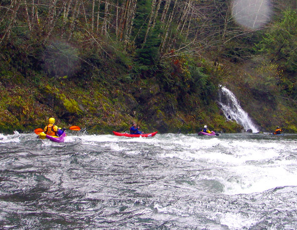
Fun rapids, scenic canyons, and an easy shuttle make this a great run, particularly after a good rain event. The run starts gently with wide, shallow Class II water. The first defined drop below Road 7300 is a nice Class III boulder garden with some decent gradient. From there, the run gradually steepens and the canyon tightens. The action builds to consistent Class III with a nice variety of small ledges and boulder gardens. Waterfalls and cascading side streams add flow throughout the run. Many folks get familiar with the river by running from Road 7300 to Road 6600 a few times before attempting the harder rapids in the lower canyon.
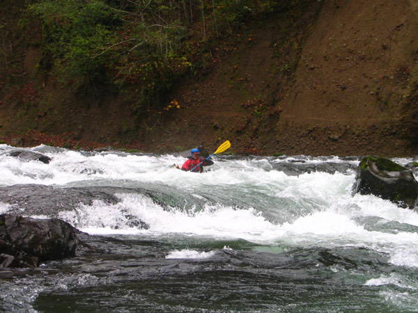
After passing under the bridge at Jacks Creek, you are about a mile upstream of Double Drop. There is one steep ledge above DD, and then immediately above it there's a short, quiet pool. Double Drop can be scouted on the left, though the view is not ideal. There is also a trail down to it on river right, but finding that might require local guidance. At low flows the first drop can be arduously portaged on the left. Double Drop begins with a straightforward lead-in as the river narrows into a tight channel and a powerful ledge. Below the ledge, a midstream boulder forces a choice: left is the cleanest line, while right will take you through some big holes. A long recovery pool sits below the drop.
Below Double Drop, Class III water continues before easing back to Class II as you approach the takeout.
Access Logistics: The takeout is located at the gate below Jack's Creek. Follow Bennett’s directions up Kalama River Road. If you have a permit, you can continue upriver to a variety of put-in options depending on the length of run you want. The gate provides access to the Weyerhaeuser Mt. St. Helens Tree Farm and while it was opened during hunting season in the past it is now only available through a limited-entry pe
...River Features
Upper Kalama Falls
A 38' waterfall at the headwaters of the Kalama River.
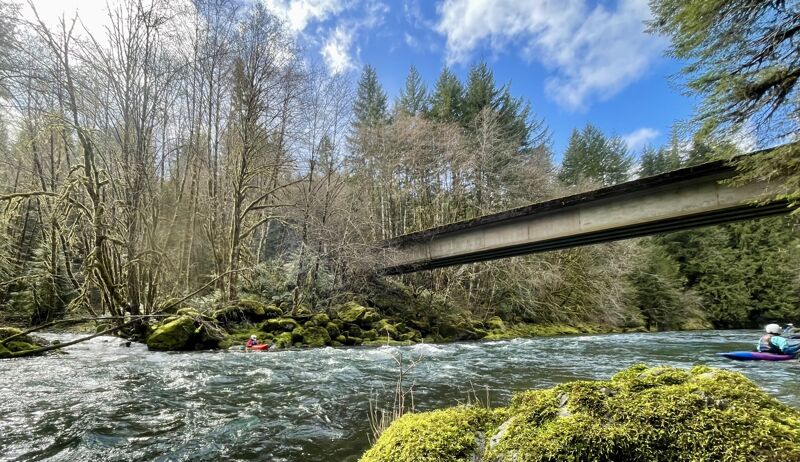
7200 Bridge Access
Access point at the 7200 Bridge, a short distance downstream of Kalama Falls.
Wolf Creek Confluence
The river leaves the road and becomes more remote as you pass through the boulder garden at Wolf Creek.
6600 Bridge, Jacks Creek Access
Access point at the Weyerhaeuser 6600 Bridge that crosses the river at the Jacks Creek confluence. This is a potential exit point for those seeking to avoid Double Drop located approximately 1.5 miles downstream of this bridge.
6450 Bridge Take Out
A take-out is available on upstream river right of the bridge. This is the take-out described in Bennett's guidebook. It is just upstream of Gobar Creek and the Weyerhaeuser gate.
Trip Reports
Log in to add a reportTwo low water laps - Teresa Gryder
Apr 21, 2026
I was one of the lucky few to get invited on a spring Upper Kalama Kampout by this year's permitholders. The river is a delightful with fantastic water quality, good clean rapids, and pretty scenery with cliffs and eagles. The bigleaf maples were just leafing out, and the dogwoods were in full bloom.
We ran it two days in a row at 440 and 420 cfs on the gauge below. I would call this low, but not very low, because there are still multiple clean lines through every drop. You could certainly go lower--not sure what the minimum is. Before the gate was closed we used to come in here without a gauge and run it high--it has a lot less playful features when high. This time I brought my half slice and did not regret it; there were lots of fun surfing waves and moves to make in the rapids.
The URL for the gauge changed last year, and currently it's https://www.licor.cloud/dashboards/public/4c98589d-ef81-4d4f-9573-bc6062d4aae0/true?filters={%22davra-timeselector%22:{%22type%22:%22relative%22,%22unit%22:%22weeks%22,%22value%22:1,%22live%22:false}}.
Double drop is, IMO, more challenging at low water than high. Perhaps this is because folks told me to run right: I found the right side of the ledge terrifying due to perceived pin risk (between R wall and whatever rock is causing the water pile in the middle). On day 2 I ran left and it looks to me like left or center can lead to a good boof and controlled exit. Some folks went straight over the woop-dee-woo (pile of water) in the middle and of those, a high proportion got awesome backenders and more excitement in the hole.
Bridge upstream of Wolf Creek to Weyco Gate - Bary Bruner
Mar 8, 2026
This section upstream of the Weyerhauser Gate is only (legally) accessable with purchase of an annual pass ($450 for 2026-27) or with a guest pass ($100 for 2 consecutive days) purchased through an annual pass holder.
A gauge was installed a few years ago, accessible from the Kalama Fire District's website. 300 cfs is quite bony; 700 cfs a bit pushy and continuious.
Six of us put in at the bridge just upstream from Wolf Creek at 450 cfs on 3/2/26. At this medium flow it is pool/drop, 2+ with a few Class 3's, for 7 miles down to the 6600 bridge. We have parked at the south end of this bridge for years without conflict but with active logging in the area currently parking has become an issue. Extremely large equipment requires every inch of roadway on either side of the bridge, so we're in the process finding suitable parking.
On this run 3 members exited at the 6600 bridge while 3 continued down the bit tougher section down to the gate. This 4 mile stretch has some delightful Class 3's and one Class 4, Double Drop. The first drop is short, ending in an unavoidable hole that flushes, but also flips. Fortunately a pool follows, allowing for a roll attempt, or two, before the next squirrelly drop. Below the drops is a large recovery pool though steep canyon walls keep most swimmers in the water until a slot on river left. The description above mentions scouting and portaging but the steep, slick canyon walls make it look impossible for me to do either (an old, febble, Class 3er). After high water events I suggest hiking down from the nearest logging road (safety rope suggested) to make sure DD isn't plugged with wood before facing consequences from the river.
It does seem hard to justify the annual expense but the solitude, scenery, and waterfalls make this run quite special.
Bary Bruner
Dec 1, 2020
Access to this section of the Kalama is now restricted to Weyerhaeuser Recreational Permit holders. $300+ a year. It is a lovely stretch of river, especially if you are able to focus on the 100 foot wide strip of trees at river's edge and ignore the clearcut devastation that now defines Pacific Northwest private timber holdings.