Kings, S. Fork
3. Boyden Cave to Middle Fork confluence(Horseshoe Bend)
| Difficulty | V |
| Length | 4.5 mi |
| Avg Gradient | n/a |
| Reach Info Last Updated | July 17, 2012 |
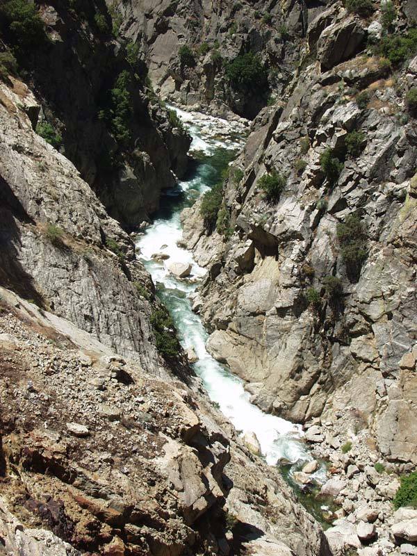
Horseshoe Bend of the SF Kings is a super scenic gorge. It is normally paddled in conjunction with the downstream Garlic Falls section. This makes an excellent 2 day trip through fantastic scenery that has been compared to the Black Canyon of the Gunnison.
If you do not have time to continue downstream or if you wish to stay in the South Fork, Cedar Grove area, there is a steep 2 mile carry out from the confluence of the middle fork to Yucca Point on Highway 180.
As reported, there are two mandatory rapids that cannot be portaged in the heart of the gorge. These two rapids can be scouted from the road and from river level. Recent trips (2012) report that the difficulty of these rapids is in the easy class 5 to 4+ range at moderate flows, so they should no longer be called 'Fear and Loathing'. Big floods in 1997 cleaned up 'Fear and Loathing' so that it is much less difficult and dangerous than in the past. Two or three drops further downstream is the next mandatory run. Scout from river right. There are bigger rapids both upstream and downstream, but all others can be walked if desired.
Taylor Cavin writes: 'The horseshoe bend of the Kings gave me the feeling of being in a deeper canyon than I have experienced elsewhere in California, with more vertical, craggy, and lichen-painted walls..... It has some challenging rapids, but I would rate the run over-all as class V, not V+. I feel that it is comparable in difficulty to Garlic Falls (aka King's Canyon), the continuation of the river downstream of the confluence with Middle Kings.
What I do wish to make known is that there is no longer a crux or 'crucible' moment in the run. I don't think that there is a need to hike out above or hike in below 'fear and loathing.' Anyone who has made it that far in the run will not find inordinate challenge in that rapid. I also think that the rapid could be re-named, much as 'old scary' on the SF American was re-named following its re-arrangement. Maybe
...
This talus slope offers one of the few access points into or out of the canyon. It is the last escape point above Fear and Loathing and can also be used as a way to get down and inspect that rapid.
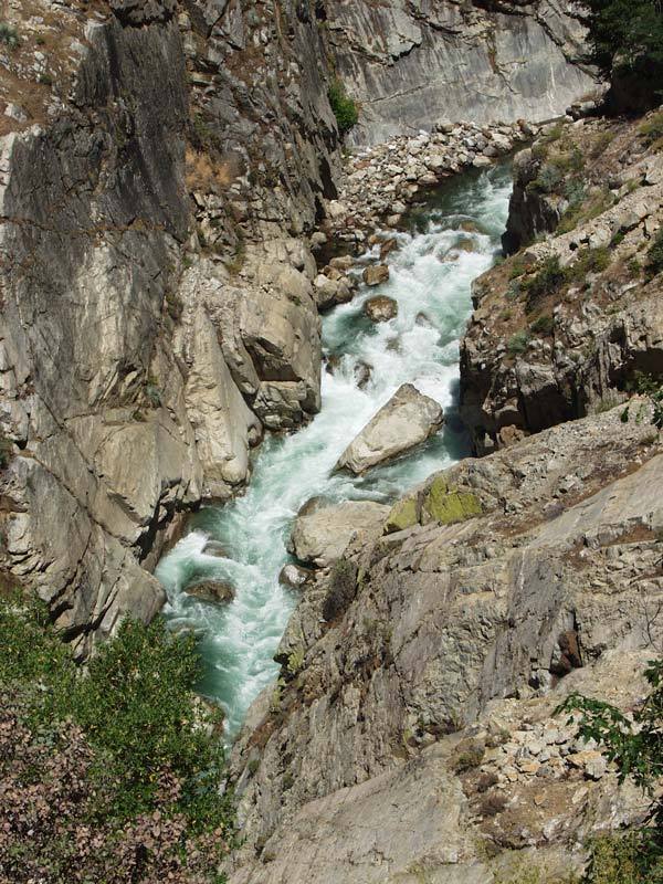
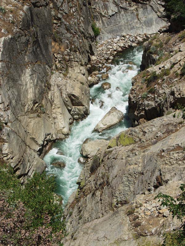
Formerly called 'Fear and Loathing', this is the first of two rapids in the heart of the gorge which can not be portaged. Fortunately over the years, high flows have rearranged and cleaned up this rapid. A nasty sieve fest which occupied the river right half is no longer there and the rapid can now also be run at low flows with out major fear pinning. Nonetheless it is still a serious rapid that must be run.
It can be scouted from the road turnouts or by hiking down from the road turnout directly above it.
This is the second rapid that cannot be portaged. You can scout on river right and easily inspect the main drop. In the past there was sneak potential on the far river left at some flows.
A rough but short fisherman's trail leads from the south end of Convict Flat, down a gulley, and over a cliff into Redwood Creek where it meets the SF Kings in the very heart of Horseshoe Bend. This trail is attractive to those who do not want to paddle the two unportagable drops just upstream. It is also attractive to some paddling the Garlic Falls section who do not want to hike the Yucca Creek trail. Others have expressed strong detest for this non trail. Strong route finding ability is important.
At the cliff it will be necessary to lower boats about 50 feet. There is also a fair amount of poison oak along the route, especially near the top and at the very bottom.
The map marker is accurate for the satellite view rather than the topo.
The river constricts to river right, then drops over a 15 +- foot waterfall. You can scout the falls on river right. We always ran it on the left edge and I seem to recall a boulder under the surface of the landing zone if you go over the middle.
There is a short pool at the base, then the river drops into the biggest rapid in this section below Redwood Creek and the Convict Flat trail. This long rapid can only be scouted on river left and those who wish to scout or portage must work hard to get left before dropping into the rapid.
Below this rapid are one or two more pretty big rapids in a really spectacular gorge.
The river flows through a very scenic gorge. Where the river makes a sharp right turn, large jaggedy boulders block the way leaving only tight, steep and twisty slots. Scout and/or portage on river right.
Below this the canyon opens out into a Vee shape and the rapids become class 4 boulder slaloms all the way to the confluence.
Jul 8, 2003
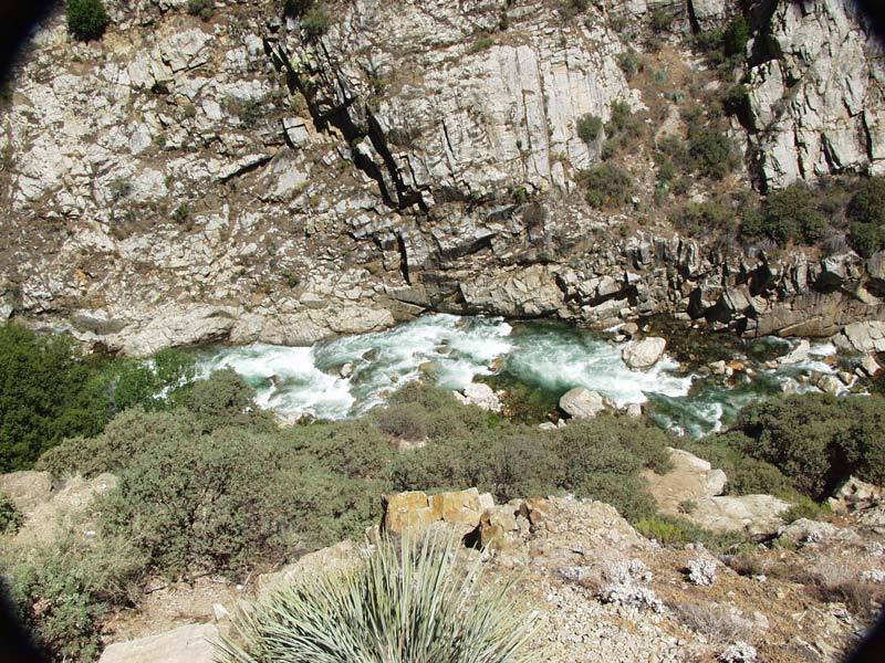
looking downstream from the Horeshoe Bend turnout. The first rapid in the foreground must be run as it can not be portaged. There is some sneak potential on the river left side, (not visible in this picture).
Jan 1, 1900
Low water in late summer, just below Boyden Cave parking area.
Looking at the lead into Horseshoe Bend. Big Drops with late summer low flows.
One of two rapids in Horseshoe Bend that cannot be portaged, at least not without great difficulty. The big floods of recent years, seem to have made the rapid less difficult.