Beaver, E.Br.
B) CR5 to CR4 (2.6 miles)

| Difficulty | III+(V) |
| Length | 2.2 mi |
| Avg Gradient | 75 fpm |
| Reach Info Last Updated | April 2, 2019 |
A stretch of flatwater paddling starts this run. The first drop starts with a steepening technical drop, leading to a short ledge which has a sticky center hole. Run either far left (with aggression), or far right (over a stepped ledge) then choose from a couple of exit routes. Just below, most of the river is a jumble of broken rock, with the deepest channel being far right alongside a high wall of rock.
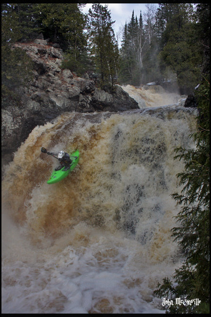
A brief paddle leads a major horizon line. Take out (river right) to scout a triple of large falls, the undeniable highlight of the run. The first is a jumbled irregular steep-sliding falls into a large, hanging (steep-sided, little chance for egress) pool. Out of this pool, the river is funnelled to the right to pour out a narrower spout into another larger pool. The river turns back to the left and (shortly downstream) drops over a wide, mostly sheer-vertical falls. (Generally this is run about 1/3 from the right, though other routes should be possible.) All three of these have been run, the first two generally at minimal levels, and the third at virtually any (river runnable) level.
Immediately downstream, a private road and pipeline cross overhead. Numerous smaller (all boat scoutable, but very fun) rapids ensue.
Take-out is via a short paddle on the ('main') Beaver River (upstream, to the right/west, in a flatwater section), encountered just downstream of a railroad crossing high overhead.

At the put-in drainage area is about 45 square miles (to the best I can do using online planimeter and topomaps).
Not far downstream, more moderate (generally boat-scoutable class III) rapids continue for a half-mile or more.
OK, technically the property lines appear to be somewhat upstream of this point, however until the point marked on the map, the banks are entirely wooded. From the point indicated by this marker, you are within the actual golf course. (Expect to pass under a number of cart bridges.)
Some paddlers may opt to take-out here to hike up the tracks back to the road and their vehicle(s). Others will paddle down to the confluence, then paddle UPSTREAM (low current) to reach the road.
Jan 1, 1900
A sweet, straight-forward drop on which to practice your 'boof'.