Sturgeon (Baraga/Houghton)
E) Sturgeon Gorge: Sturgeon Falls to NF2270/FSR193 (4.87 miles)

| Difficulty | II-III(V+) |
| Length | 4.7 mi |
| Avg Gradient | 31 fpm |
| Gauge | Sturgeon River Near Sidnaw, Mi |
| Flow Rate as of 28 minutes | 53 cfsbelow recommended |
| Reach Info Last Updated | December 28, 2024 |
NOTE: We have no awareness of best runnable flows. All flow ranges are merely tentative. Create a 'Trip Report' stating listed flow and your impressions (low/moderate/high).
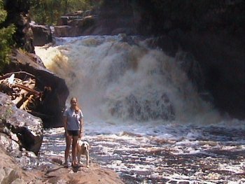
Experienced, skilled, and appropriately cautious paddlers may opt to minimize the carry-in and start at the head of the gradient (as given by the presently indicated put-in). This gives very nearly a half-mile of fine rapids leading to Sturgeon Falls. A sharp jog to the left precedes this very dangerous and deadly falls. For any and all less-skilled or timid/uncertain paddlers, we recommend instead carrying that 0.5 mile down the trail to put in below Sturgeon Falls.
Take-out is at Sturgeon Gorge Road bridge, just above Prickett Lake. Downstream of that dam, save one spot, the river is all slow, meandering low flood-plain lazy river.
This section is very scenic and mildly playful depending on water. The run starts with some Class II low angle sloping ledges and wave-holes, later turning into numerous boulder rapids with an occasional small surf wave. The majority of the whitewater features are located in the first half of this reach, which averages about 50'/mile. The second half is primarily a moving water egress paddle.
This reach, combined with the 10.9 miles of river upstream of Sturgeon Falls, is a fairly popular canoe run through a scenic valley. Starting from the USFS Sturgeon Road campground there is mostly quietwater until a short distance above the falls. For those without whitewater experience and equipment, caution is advised in the approach to the portage for the falls, especially at flows above our listed 'minimum'. There's only a small eddy before Sturgeon Falls. While there are some sweet rapids (waves and holes) in the stretch above the falls, there is extreme risk of going beyond the 'point of no return' and being swept into/over the falls. There has been at least one death as a result of mis
...
We are not aware of any (intentional, successful) runs of this falls.
If you put-in and run from any place upstream of this falls, be keenly aware of flows and be ready to catch the river-right eddy at the jig-jog above this falls to make your portage.
Downstream of Sturgeon Falls action quickly subsides to a bit of fine wave-train. As the river takes a sharp bend to the left, it encounters a couple small holes to either shore, then a river-wide ledge which (at some flows) appears it could get quite aggressive.
The river continues with lighter rapids, and (generally) broad sweeping turns. After a broad left turn, as the river turns more sharply right, encountering an island, the second 'marked' rapids occurs. Expect nearly a quarter-mile of increased action with waves and occasional holes. As action subsides a bit, the river takes a hair-pin turn to the right, encoutering an impressive vertical wall.
As the river sweeps back to the left, the third marked rapids occurs. Again, expect waves and some offset-holes as the river twists left, then back to the right.
As the prior rapids subsides, the river does another fairly tight right, then back left. As it does, it encounters the fourth (and final) marked rapids. This appears to be the least significant of all. Good waves and current continue to maybe about mile 3.0, before diminishing to just flowing water.
USGS lists a sampling site at this location citing drainage area as 335 square miles.