Wolf, W.Br.
above Neopit millpond to Wolf River (16 miles) ** ACCESS ISSUES **
| Difficulty | II-IV |
| Length | 15.6 mi |
| Avg Gradient | 15 fpm |
| Reach Info Last Updated | September 26, 2022 |
This reach lies entirely within Menominee tribal lands. It is NOT LEGAL for all non-members of the Menominee Tribe to paddle or explore the drops described here. Driving any 'Indian Roads' may also not be permitted. If in doubt in Menominee County, stick to paved roads (state and county highways within the reservation). Arrest and conviction on trespassing charges in Menominee county may result in fine, imprisonment, and confiscation of materials used in the act of trespass up to and including vehicles!
This reach is included on the AW inventory for the sake of completeness and (more so) as a warning regarding exploring these areas.
While paddlers know the popular Wolf River quite well, it's West Branch is almost an unknown due to the restrictions placed upon non-Menominee tribal members within tribal land. The information contained below has been obtained through interpretation of available data and conversation with Menominee tribal members.
Top West Branch - 0.4 mile
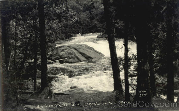
From spring fed headwaters near Elton, the West Branch meanders through forested (and at times marshy) lands before encountering gradient a short distance above Neopit Millpond. Through a series of small falls and cascades, the river drops 48' in 0.4 miles here for an equivalent gradient of 120'/mile. River size here should be roughly equivalent to that of the Red River at River Road. (Note: our listed hypothetical 'put-in' has no apparent road or path, and is merely a marker of the beginning of the significant gradient here.)
Upper West Branch - 9.0 miles
Below the Neopit Dam, the West Branch becomes similiar to Section 4 of the Wolf
...
USGS lists a sampling site immediately downstream of Neopit Mill Pond Dam citing drainage area of 98.6 square miles.
USGS lists a sampling site upstream of our 'theoretical put-in' above Neopit, showing drainage of 41.8 square miles.
USGS lists a sampling site at West Branch Road (just downstream of Bear Trap Falls) with drainage area of 163 square miles.
