San Joaquin, Middle Fork
Devils Postpile Nat'l Monument to Mammoth Pool Reservoir
| Difficulty | V+ |
| Length | 28.1 mi |
| Avg Gradient | 120 fpm |
| Gauge | Mf San Joaquin R Nr Mammoth Lakes Ca |
| Flow Rate as of 58 minutes | 87 cfsbelow recommended |
| Reach Info Last Updated | September 29, 2010 |
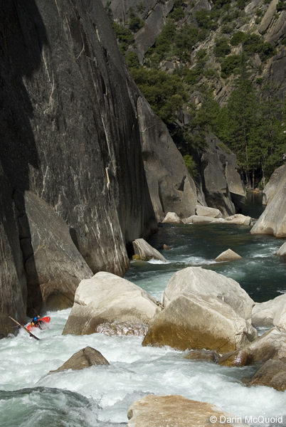
The San Joaquin River is one of California’s most significant whitewater rivers, flowing from the high Sierra Nevada through the steep granite walls of the San Joaquin River Gorge Special Recreation Area. It is also one of the most intensively developed hydropower rivers in the state. For over two [...]Read More
The Middle Fork of the San Joaquin is now getting boated by one to several groups a year in most years. It seems likely this incredible canyon will become steadily more popular.
More and more of the drops are being run, but many portages are still necessary. The famous Crucible section is often paddled now, so that big portage has been eliminated by some groups.
Season: This reach must be boated as flows drop near the very end of the run off season. Often this will be in July. In wet years, the best boating levels could be in August.
Put-in elevation: 7,545 feet (2300 meters)
Take-out elevation: 3,330 feet (1,015 meters)+- (varies with elevation of Mammoth Pool)
Google Earth has excellent hi resolution aerial images of much of this section.
Put in:
It is not legal to paddle within Devils Postpile itself, so hike boats downstream on the trail to the monument boundary before launching.
Other Information Sources:
Devil's Postpile Headquarters: 760-934-2289
Jefferson State Creeking Blog by Darin Mquoid
Devil's Postpile V-V+ (P) [Middle Fork San Joaquin] -Day One-
Devil's Postpile V-V+ (P) [Middle Fork San Joaquin] -Day Two-
...
A trail crosses the river here. A gauging station operated just upstream of the bridge into the 1980's.
No trip reports yet.