Stanislaus, S. Fork
Hwy 108 Bridge to Lyons Reservoir(Strawberry)
| Difficulty | IV-V |
| Length | 11.7 mi |
| Avg Gradient | 94 fpm |
| Gauge | Sf Stanislaus R at Strawberry |
| Flow Rate as of 22 days | 13 cfsstale data |
| Reach Info Last Updated | October 31, 2013 |
Put in: Highway 108 bridge. Elevation 5290 feet.
Take out: Lyons reservoir. Elevation 4215 feet.
Total drop 1075 feet over 11.5 miles.
There appear to be numerous options for put in and take out. Study a map.
Jay Seiler reports
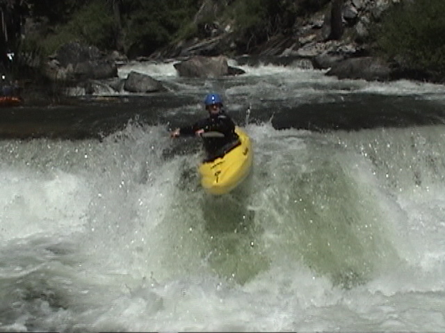
This run was a lot of fun. We estimated it to be around 11 miles from a few miles above the campground to about 3 or 4 miles below it. Great class 3-5.Two tricky dams above the campground. Below the campground there were two class 5 drops separated by continuous 3-4 drops. First class five portage on the right. The last mile of whitewater was the most fun-Six drops in a row. First one is class 5, one of us in our group ran it blind-the next day we all walked it. Hard to see-must make eddy on the left. Portage left. The next 5 drops are all class 4+ drops back to back sticky holes all down the left-run right. Take out on the river left after a mile or so on a logging road I believe-past the powerlines. Scout for wood and drops you might not want to try. Have fun.Be safe.
Other Information Sources:
A GUIDE TO THE BEST WHITEWATER IN THE STATE OF CALIFORNIA, HOLBEK & STANLEY, 1988

PG&E is required to start posting flow information from this gauge, USGS #11296500.
This dam may or may not be a portage. Scout carefully.
PG&E is required to start providing hourly flow information from this gauge, USGS 11297200.
Jul 24, 2006
Another note, Some of us found it easier to portage both class 5 drops on the right. Also watch out for the tree at the end of the run. Big tree lying across the river-catch the eddy under the tree on the right-its a bit of a limbo-and watch out for the undercut behind the eddy.
Jul 24, 2006
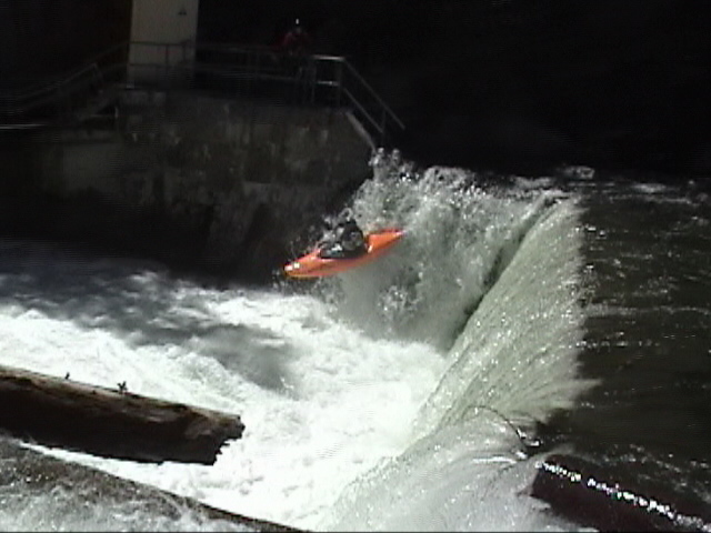
We ventured back into the S. Stanislaus again this summer(late June 06) and found it at around the same flow as the year before. We found drops upstream of the put-in above Hwy 108. There are a series of drops back to back with a drop in the middle that had some issues. We put in below the sketchy one. Not sure what lies further upstream but there was good water and there are gradient lines on the map...maybe check it out further next year. The rest of the run was great-no wood. Except for the First Dam. There is a pipe suspended across the lip of the dam. We were forced to run the dam in the left of center-unlike our far right boof last year(pictured Dam). The 2nd Dam dished out some punishment to one of our group members. The spouting man made 4 foot vertical drop has a sticky and powerful hole at the bottom and apparently is not too deep. Running left of center avoiding the hole seemed most sensible. Continuing on downstream, We ran the two portages we made last year, basically our whole reason for going back in. The first one you can scout from the take out road on RL. We ran it down the left. The second one above the series of drops at the end was only run by myself, but was fairly clean. Run down the right and boof through a narrow notch at the bottom.I called it 'The Cervix'. Great fun run-class five skills required-especially if no one in your group is familiar with the run. Our first run took us 6 hours. After we knew it well, our second run took 2 1/2 hours. All drops have been run below Hwy 108. Have fun.be safe.
