Birch
2. Cora Brown Bridge to the confluence of Diatter Run(Cora Brown Bridge to end of Smith Eddy)
| Difficulty | I-III |
| Length | 11 mi |
| Avg Gradient | 27 fpm |
| Gauge | Birch River at Herold, Wv |
| Flow Rate as of 1 hour | 2.12 ftbelow recommended |
| Reach Info Last Updated | December 28, 2024 |
An informal gauge is found on the pier of the Herold
Bridge. Ideal conditions will show 5 blocks of stone. Current conditions
are showing all 6 stone blocks @ June 7, 2001.
This section of river is included in the West Virginia Natural Streams Preservation Act. Although not included in the National Wild & Scenic Rivers Act, this section of Birch was studied in 1982 and met the criteria for induction. Local landowner indifference and lack of public land were the 2 reasons this section of Birch is not in the NWSRA. It has also been overlooked by the NRI. Currently, that situation is in the process of being remedied. Look at the website www.scenicbirchriver.com for additional information.
A take-out may be made at the bridge above Herold at 6.1 river miles.
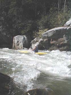
Another take-out may be made downstream of the Herold bridge on river left. Parking is (limited) near cliff face when road starts going uphill and away from river. This makes for 7.4 river miles with some of the better class III rapids included. The take-out at Diatter Run may be made from river right or left depending on how much abuse your four-wheel drive shuttle vehicle is willing to take. If continuing from here it is an additional 6.9 miles of scenic but flat water paddling to the confluence with the Elk River.
May 20, 2021
The guidebook takeout (Herold)has a wide spot where a big rock juts out into the road. I have not tried parking therebut have noticed recently that the 'no trespassing signs' are now gone between the road and the river. So maybe it's good to go again?
Upstream at the Herold Bridge there is a small wide spot to park at next to the bridge. Take out just upstream of the bridge on river right. A nearby land owner named Matt may tell you it is dangerous to park there but we have had no incidents in the past 20 years (ignore him).
Do not ask to park near Matt's house. He has consented to let me take out there but he is not giving others permission.
Jul 13, 2020
parking at the cliff face is posted no trespassing so the bridge at herold is usually where we take out. Most folks will like 5'-6' on the online usgs gauge located at herold bridge. The low end estimates are off a little bit now. 4.5 is better minimum than 4.0. The rapids below the herold bridge at higher water (7 ft) do not wash out but become more difficult. Always watch for wood on this run.
Sep 13, 2016
the current gauge that is linked to this page is way over in webster springs. The usgs currently operates a gauge on the Birch at Herold (the takeout). On the Herold Gauge: 4 ft and below begins to get scrapey, 4.5-5.0 is good for novices, at 6 feet the rapids start to link up with one another and shore eddies become scarce.
Keep your eyes open for wood on this run.
The access to the river for parking by the cliff is now heavily posted with no trespassing signs. We usually park near the bridge in Herold and take out there without incident.
