Beech Creek
Ryker to Hwy. 21 (7.5 miles)
| Difficulty | III-V |
| Length | 7.5 mi |
| Avg Gradient | 90 fpm |
| Gauge | Buffalo River Near Boxley, Ar |
| Flow Rate as of 40 minutes | 18 cfsbelow recommended |
| Reach Info Last Updated | April 7, 2025 |
Note: The combination of Steep banks and lots of deadfalls tend to clog the creek with wood from time to time, so keep look out.
Ozark Creekin' at its best. Not super steep but lots of class III action with several class IV-V drops mixed in. Some of the highlights include, Shotgun, Door #4, Beech Ball, White Lightning, Beech Falls and numerous others that don't have official names.
Typical hazards include, downed wood, undercuts, sieves, pin/piton rocks and stout holes.
Spray Paint Gauge on the Highway 21 Bridge Pillars on River Right. Look for 4' and steady or rising, or 5' and falling for a good run. AW Online gauge References Boxley, which is the closest proxy.
Put in: Hike in from Cave Mtn. Rd. near Ryker just past the Whitaker Point (Hawksbill Crag) trail head(actual put-in is on Edgemon Creek . GET PERMISSION FROM LOCAL LANDOWNERS BEFORE TRESPASSING ON PRIVATE LANDS. Aim for the just above the confluence of Evans Hollow.
Take out: Hwy 21 bridge just upstream of confluence with Buffalo River. Parking is available at the Cave Mtn Road/Hwy 21 intersection near the Buffalo River 'Boxley' bridge 150 yards south of the Beech Creek bridge .
See the description at Ozark Whitewater Page.
Put-in requires carrying down a trail. First half of the run is on Edgemon Creek.
If water level and time permit, carry up and run the last couple drops on Beech Creek.
The run starts in the Ozark National Forest and ends inside the Buffalo National River Park. However most of the run is on private land.
See some video of the creek here.

Park in the field. Please do not block the drive, leave trash, tire ruts, etc. This is private property and are granted the courtesy to park and hike down to the creek by the landowner. Follow the old road/trail North to the creek just upstream of the confluence with Evans Hollow.
As noted in the description, put-in is actually on Edgemon Creek just above confluence with Evans Hollow. At the listed put-in drainage area is ~3.62 square miles (as calculated by USGS StreamStats 4.2.0 software).
By the listed take-out it has increased to ~19.4 square miles.
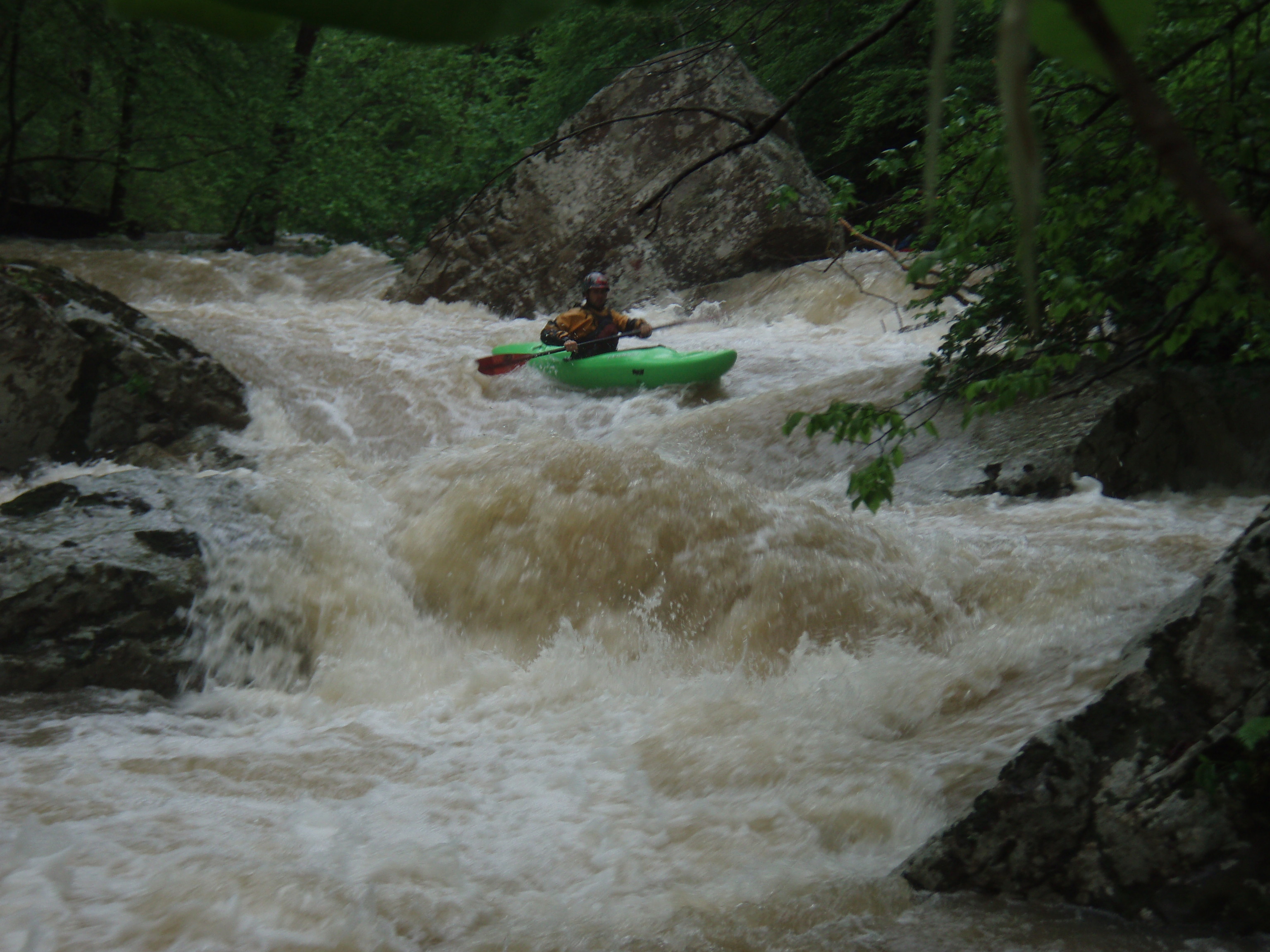
Small waterfall/tall ledge at the confluence of Evans Hollow. Can develop a stout hydraulic at high water levels.
The next couple miles are tight and technical. Watch for wood.
Flow funnels to the right, then spreads out as it shoots you down a low angle slide.
Stay to the right and avoid the first 2 doors on the left. The 3rd door can collect wood, Door #4 is the preferred line.
Small entrance ledge to the main drop with the 'Beech Ball' blocking the main flow.
Beech Creek joins Edgemon Creek to add volume for the rest of the run.
There are a couple of class IV, IV+ rapids on Beech Creek above the confluence for those who want to hike up to check them out. Above those, the creek is relatively rapid free.
After the creek squeezes into a 8 foot wide slot between boulders lies a ledge of boulders with several routes available. The runout slide/ledge can develop stout hydrualics at higher water levels
Long wide bedrock flume that develops big waves at higher levels.
More of a bedrock slide, but avoid the roostertail on river right.
An undeveloped road leads up the hill to river left just above the rapid.
After the ledge downstream of Beech Falls lies the last main rapid of the run. This is also one of the most technical. Main flow enters center to right the cuts back to the left over a small ledge. The left side has pin potential and the hole can be stout.
An undeveloped road exists a short distance up the hill to river right if needed.
No trip reports yet.