Nason
1. Berne to Merritt (Upper)
| Difficulty | IV-V |
| Length | 7 mi |
| Avg Gradient | 84 fpm |
| Gauge | Nason Cr. Nr Mouth |
| Flow Rate as of 3 hours | 71 cfsbelow recommended |
| Reach Info Last Updated | May 25, 2025 |
The Okanogan and Wenatchee National Forests encompass more than four million acres and are jointly managed with headquarters in Wenatchee, Washington. The rivers flowing through these forests are essential to the whitewater paddling community—both as close-to-home runs for Washington residents and as classic objectives for paddlers traveling from across [...]Read More
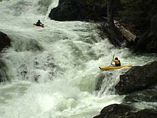
The river starts out with The Slides which is a set of class IV ledges. You can scout these drops before the run from Highway 2. If they make you nervous then you're best off heading someplace else, but if they look like fun you should be good to go. After the Slides, the creek passes through the railroad tunnel and then under Highway 2. It mellows for quite a bit before you hit a couple ledges. When you see the railroad grade on the right, get out for a scout. This is the start of the canyon which you can check out from the rim. You can walk the entire rim down to the railroad bridge (be sure to check the last ledge below the railroad bridge which has a bad spot on the left). Keep in mind the ledges are stickier than they look from above. Trivial Pursuit and Royal Flush are a class V combination. After you pass under the railroad bridge there are more fun ledges until you reach the confluence with Whitpine Creek where things start to mellow, eventually slowing down to class II.
Access: The put-in is at the pullout at Highway 2 mile 71 just east of Steven's Pass although this is marked 'no parking' so you will need to find a pullout just downstream (check the other side of the highway). If you continue down the road you'll be able to see the creek and The Slides along the north side of Highway 2. To reach the take-out, head to Highway 2 mile 78.3 and turn on to Whitepine Road which is signed for Cascade Meadows. Follow this road 1 mile to where both the road and the railroad cross Nason Creek. You can take-out on river left below the railroad bridge. The Bennett guidebook idenifies a take-out at Highway 2 mile 78.7 where the creek comes up against the highway but this access requires running a little over a mile of low-gradient channels that can collect wood.
for additional information see:
Bennett, J. and T. Bennett. 1997. A guide to the whitewater rivers of Washington, second edition. Swiftwater Publishing. Portland, OR.
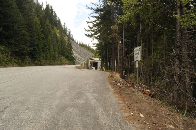
The put-in is at the pullout is adjacent to the east portal of the Cascade Railroad Tunnel at Highway 2 mile 71, a short distance east of Stevens Pass. The pull-out is marked 'no parking' so you will need to find a parking spot just downstream (check the other side of the highway).
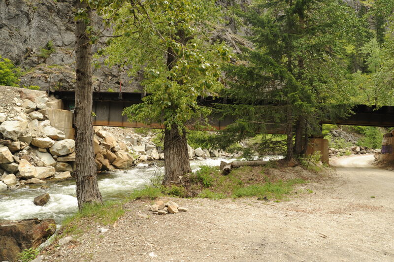
To reach the take-out, head to Highway 2 mile 78.3 and turn on to Whitepine Road which is signed for Cascade Meadows. Follow this road 1 mile to where both the road and the railroad cross Nason Creek. You can take-out on river left below the railroad bridge. The Bennett guidebook idenifies a take-out at Highway 2 mile 78.7 where the creek comes up against the highway but this access requires running a little over a mile of low-gradient channels that can collect wood.
Jan 1, 1900
Video footage from the Twitch
series, featuring runs from
Washington and around the world.
Available through the [books & videos link](http://
www.americanwhitewater.org/library/
).
Video footage from the Twitch
series, featuring runs from
Washington and around the world.
Available through the [books & videos link](http://
www.americanwhitewater.org/library/
).
