Waptus
Waptus Lake trail to Salmon La Sac
| Difficulty | II-III+(IV) |
| Length | 2.2 mi |
| Avg Gradient | 64 fpm |
| Reach Info Last Updated | June 5, 2025 |
The Okanogan and Wenatchee National Forests encompass more than four million acres and are jointly managed with headquarters in Wenatchee, Washington. The rivers flowing through these forests are essential to the whitewater paddling community—both as close-to-home runs for Washington residents and as classic objectives for paddlers traveling from across [...]Read More
The Mountains to Sound Greenway stretches more than 100 miles along Interstate 90 from the shores of Puget Sound in Seattle, across Snoqualmie Pass, and into Central Washington. Encompassing over 700,000 acres of public land managed by local, state, and federal agencies, the Greenway protects an extraordinary landscape that [...]Read More
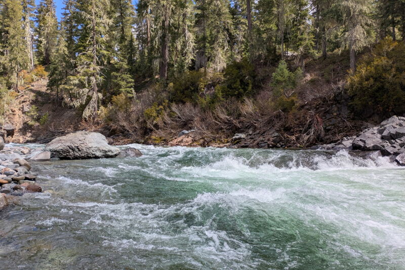
The Waptus River, a significant tributary of the Cle Elum, offers a distinctive Class II-III boating experience in a wilderness setting that stands apart from the steeper nearby runs on the Cle Elum and Cooper Rivers. Flowing through a broad, open valley within the Alpine Lakes Wilderness, the Waptus delivers nearly continuous rapids without major drops, making it an ideal destination for intermediate packrafters seeking a remote adventure that is still accessible as a day trip. The river’s wide channel and minimal sweepers make navigation manageable, while its steady gradient and fun whitewater provide ample excitement. With its clear, cold waters during the typical June snowmelt season, and an approximately 3 mile hike-in approach that limits usage, the Waptus is a rewarding blend of solitude, backcountry travel, and fun whitewater.
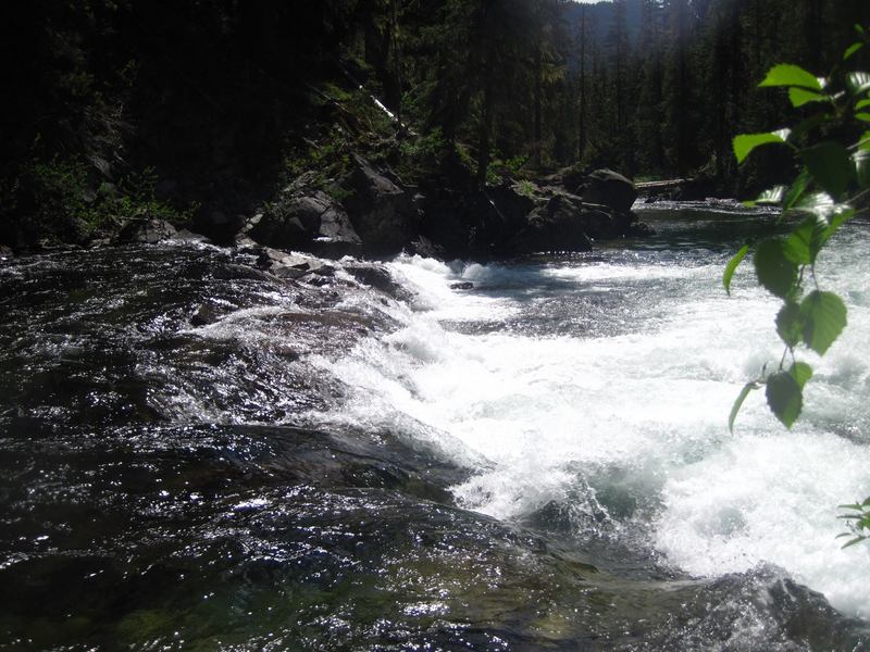
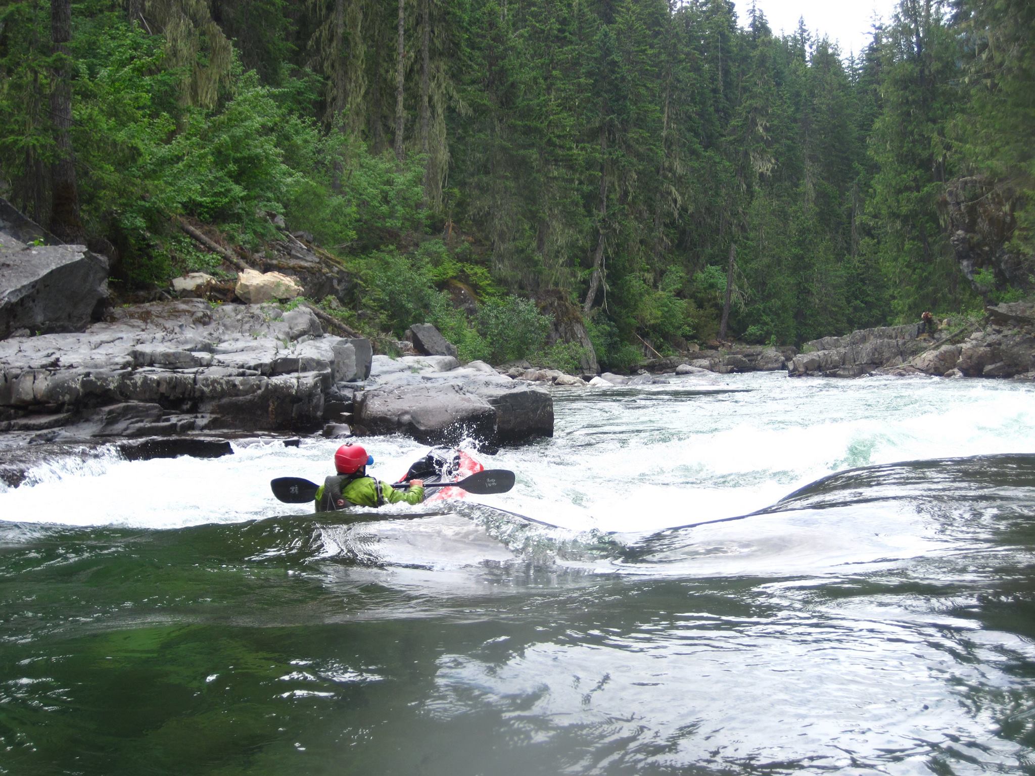
The run begins with continuous Class II rapids, interspersed with straightforward Class III sections formed by bedrock ledges. Midway through the journey, paddlers encounter “Little Zeta,” a tight, Z-shaped rapid that marks the most challenging spot on the route. From there, fun and splashy rapids continue all the way to the confluence with the Cle Elum River above China Point. Here, it's important to stay right to avoid the infamous “Waptus Hole.” Once on the Cle Elum, boaters can enjoy the Class III-IV China Gorge section, which provides a fun and challenging finale to the trip and continues downstream to Salmon La Sac.
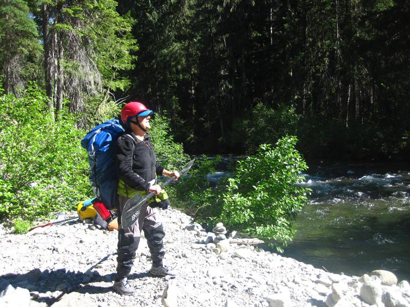
Access: From I-90, take exit 80 and head toward Roslyn/Salmon La Sac (those arriving from the east can take exit 84). From the freeway, it’s 20 miles to the Salmon La Sac Campground, mostly along Highway 903. Cross the Cle Elum River bridge at the entrance to the campground and park upstream, river right of the bridge. This is the take-out, located on the Cle Elum. To reach the Waptus River, continue on foot from the take-out on the Cle Elum River a short distance on the road to the Salmon La Sac trailh
...
This is a recommended starting point for river journeys where the trail comes up along the river at the confluence of Hour Creek with the Waptus River.
Confluence with the Cle Elum River. The run continues for 1.4 miles on the Cle Elum on down to Salmon La Sac. Be aware of the Waptus Hole at the confluence and China Falls, a class V rapid that is typically portaged on the right, that is just downstream of the confluence.
The trip starts and ends at the Salmon La Sac Campground's day use area adjacent to the river and on the upstream river right side of the Salmon La Sac Bridge. This is the point you drive to where you take out on the Cle Elum River. From this point start your hike a short distance up the road to the trailhead and then continue on the Waptus Lake Trail.
Apr 25, 2026
The Waptus & Cle Elum loop checked all the boxes. Beautiful hike. Wilderness paddle. Towering gorges. Wide open mountain views. Great surfing. Multiple access points depending on your whitewater appetite. What more could you ask for? — On 4/25/26, Ariel, Robin, and I paddled the Waptus and Cle Elum. We had so much fun Ariel and I repeated the next day! We put in below Waptus falls and took out at the last bridge before the reservoir. Calculated inflow to Cle Elum resevoir was low at 1300 day one and 950 day two. There was one river wide sweeper clogging a drop on the Waptus that we portaged river left, otherwise the runs were clean of wood. — The hike was really pretty! It felt like a fun blend of Eastern and Western Washington forest. We stepped over or around about a dozen or so easily navigable blowdowns. Only a couple small snow patches remained of this year's dismal snowpack. We crossed hour creek climbing over a little logjam to keep our feet dry. The camp with a view of Waptus falls was a nice spot to grab lunch and inflate the boats. (47.4403667, -121.1193259) — The paddle started out with some chill class II with some peekaboo mountain views. The evergreens grow right up to the bank and tower over the river. About halfway down the Waptus some fun little class III’s start to emerge. One of which was clogged by a sweeper, portage river left. A far left sneak underneath was possible, but a rock clogged the landing pad at our flows complicating the move. At 900cfs, the Waptus was starting to feel a little boney. I wouldn't want to go too much lower. (47.4256720, -121.0958390) — We splashed through a few more fun class IIIs until we got to the z rapid, which was certainly the crux of the Waptus. It could be scouted from river right, and it's possible to portage the first half of it. But the half portage puts you in at a kinda messy part of the rapid, so make your own judgement call with what looks easier. It felt III+ or IV- to me. Pushy, meaty, with a few barely submerged f-u rocks in speedy current. The good news is that it is short and there is a nice recovery pool below. It also serves as a good litmus test for lower China. If Z felt scary, maybe consider taking out at the confluence / Davis peak bridge. If it felt easy & fun, you might really enjoy lower China! (47.4227123, -121.0896349) — Almost immediately after the confluence with the Cle Elum is Waptus hole. We got out of our boats river right at the confluence to scout it out. We ended up taking the sneak route far right, which was a bit complicated by some guard rocks on the right, and some current pushing us left towards the hole. Maybe next time if I'm going to scout and sneak it anyways, I'll just take the easy portage route on the right. (47.4186172, -121.0876249) — After Waptus Hole there were a few fun rapids until you hit the calm stretch before China falls. It was probably 75 yards long with a couple good eddies to take out on river right above the falls. Portage was easy. The falls are an impressive sight! (47.4146599, -121.0930718) — From here on the whitewater felt mostly IV- with a couple rapids that felt almost class IV to me. Really fun high quality whitewater though! There were a couple holes I was glad I didn't end up in and a couple undercut rocks that looked a little spooky. But otherwise, dang! What a fun ride! And despite the low flows, still plenty of water. I can see going quite a bit lower for a more technical, rockier run, with longer recovery stretches. And the scenery… wow. Impressive gorge walls with more towering trees above. What a cool section. — On day one we actually took out at the bridge below the gorge. I ran the half mile back to the Waptus lake trailhead to grab the car. Maybe next time if all we are doing is this fun triangle (Hike / Waptus / Lower China), I'd start the hike from the bridge to have the car waiting for us. (47.4030457, -121.0974408) — Day two we passed under that bridge and headed all the way to the last bridge before the reservoir. The river opened up with big views of the surrounding mountains. We managed to pick the correct channels to avoid running aground or portaging wood. Braids here are active. There were some really fun surf waves along the way! Eventually we took out at the last bridge and called it a weekend. Good times (47.3557135, -121.1068667) \---