Crooked
2. Crooked R. Ranch to Billy Chinook Reservoir
| Difficulty | III+(IV) |
| Length | 10 mi |
| Avg Gradient | 35 fpm |
| Gauge | Crooked River Blw Osborne Canyon, Nr Opal City, or |
| Flow Rate as of 1 hour | 111 cfsIII-IVlow runnable |
| Reach Info Last Updated | March 10, 2026 |
The National Conservation Lands—a 26-million-acre collection of national monuments, wilderness areas, wild and scenic rivers, trails, and historic sites—are managed by the Bureau of Land Management (BLM) to conserve some of the most treasured landscapes in the American West. Established administratively by the BLM in 2000 and made permanent [...]Read More
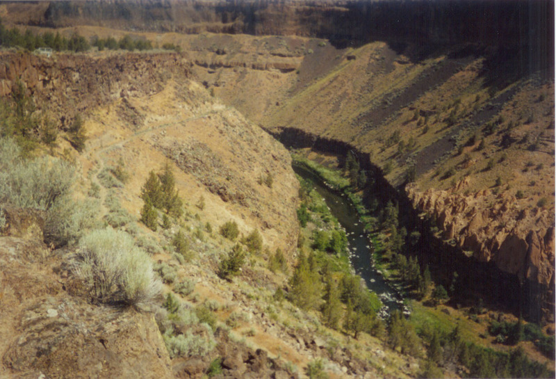
Central Oregon’s Wild and Scenic Crooked River flows through stunning basalt canyons in Central Oregon’s high desert. The region attracts outdoor lovers from around the state and the region, and provides one of the most challenging and outstanding whitewater runs in the West. The Crooked, which is a major [...]Read More
In high water this reach is often run as a continuation of the Upper Crooked, particularly by rafts that don't have a practical means of taking out at Crooked River Ranch. Known locally as the Lower Crooked.
At base flow, this reach can be run by itself as springs provide sufficient inflow through the summer for kayakers and packrafters. With some boney rapids, the one mile hike in, and an option for a two mile hike out this makes a great packraft day trip. The best gauge to refer to is Crooked River at Osborne Canyon, or COBO. This will give you an idea of how much flow you will start at China Dam with. Springs will add ~1000cfs throughout the run. Anything over 100 cfs is runnable, though over 150 is even better. Rafts would not have such a good time at summer flows. The primary issue for either rafts, or kayaks doing this section is access which is less than ideal on both ends of the run.
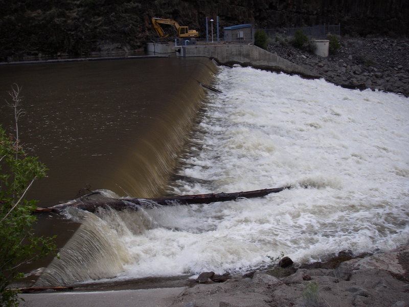
The dam at Opal Springs generates hydropower and is a 4.3 MW project licensed by the DeschutesValley Water District as FERC Project 5891. The project was licensed in 1982, constructed in 1985, andwill be eligible for relicensing in 2032 when the current license expires.
Logistics
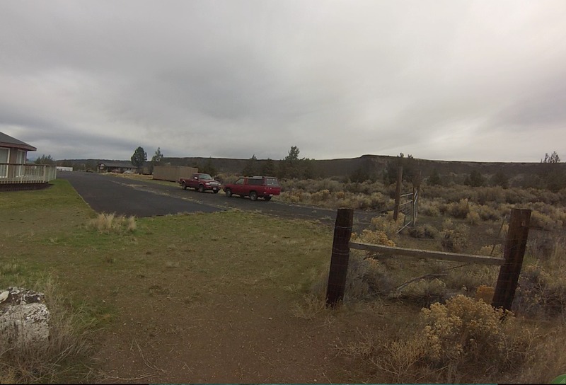
To reach the put-in from Terrebone, head north on Highway 97 but before you cross the river headwest at Highway 97 mile 115.3 on Lower Bridge Road towards Crooked River Ranch. Follow Lower Bridge Rd. 2.1 miles and turn right on NW 43rd St. Continue 1.8 miles to the T junction and turn left onNW Powey Ave. Continue on this road, which becomes Chinook Dr., for 3.2 miles as it drops down tothe golf course and turn right on Clubhouse Rd. Drive in 0.4 mile heading right at the church and pastthe cabins to parking along a fence a short distance from the gorge rim. From this parking spot, youcan hike the old Hollywood Road which is the gate to the east of where you park. The road is no longeraccessible be vehicles
...In low flows, you'll want to put in somewhere below China Dam
This is the first challenging low water rapid, I call it Entry Mank because springs have not yet filled in the flow and rocks are difficult to avoid. Over 200 cfs it gets easier. Can be portaged on rocks on river left.
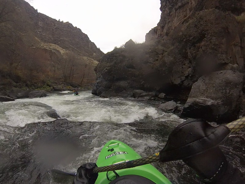
At low flows this is the crux rapid of the Lower Crooked. You'll enter a flat lake of water that is stopped up behind the rockfall that creates the rapid. Get out and scout on river left. The main run is full of boulders and pin rocks, and is known to catch wood regularly. Portage is fairly easy on river left across boulders. At higher flows the Wave has a tongue right of center and a large standing wave at the bottom.
Steep at first, switchbacks up river and into a gully, and then flat trail to Otter Bench Trailhead. A nice two mile walk suitable for packrafters to make the shuttle easy.
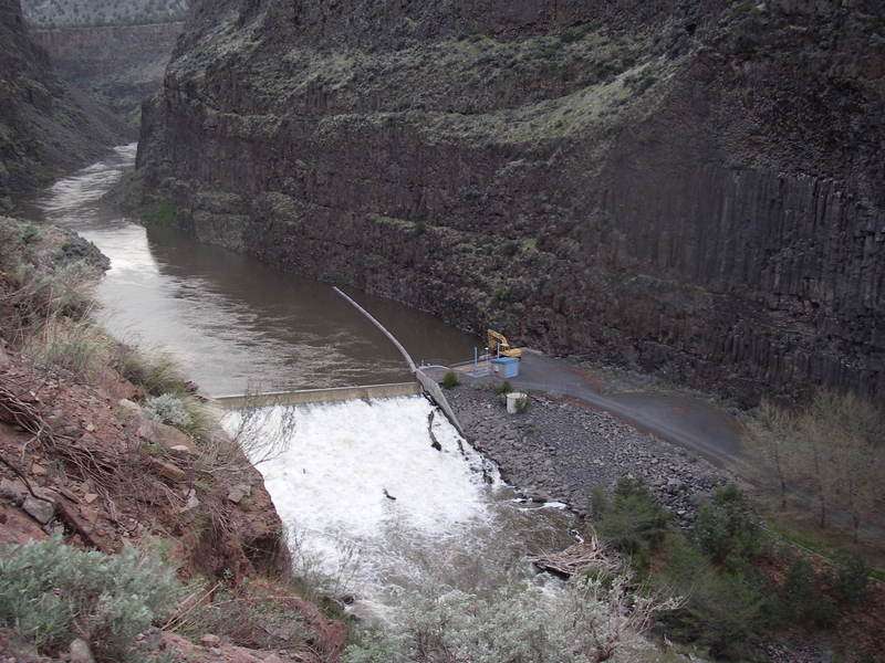
Small hydropower project requiring a portage around the dam. This can also be used as an access point for those willing to hike up the private access road to the rim (it is gated so personal vehicles can not be used to drive down to river level).
Feb 6, 2024
Crooked below osborne canyon gauge was at 2000 CFS (6.6ft)! Reminder to park in the red cinders by the church at the put in to keep the relationship between boaters and locals cordial!
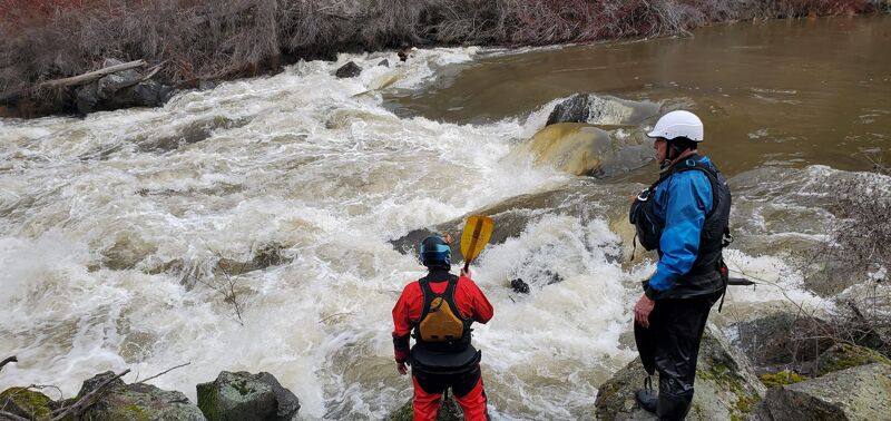
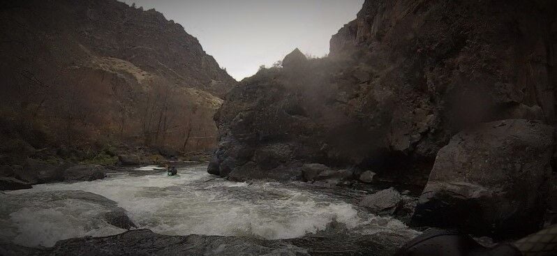
At these flows, almost every single rock is well underwater. The run started off with a bang as the normallly technical boulder gardens were completely underwater and formed a frothing series of pushy wave trains, holes, and boil lines that felt like a big water run in the tight canyon (Class IV). We didn't note any particularly dangerous features other than some submerged trees on the edges, but some of the pushy flows crashed into the canyon wall or took you towards some hefty holes.
One of our group in a playboat was swallowed by a wave and swam through the last of the first three rapids, rescue of boater and boat wasn't too difficult in the fast moving pool below but act quickly, the water is bookin through this and ferries across the river required downstream movement.
This was the hardest water of the run, and repeated itself at The Wave and the final rapid below the dam.
After the intial rapids, the river consisted of fast moving slackwater interrupted by class III wave trains with catch-on-the-fly but near perfect play waves and holes interspersed throughout.
The Wave was still easily visible as a clear horizon line, though almost all of the rocks that normally guard the entrance were underwater. Portage on the left was harder at high water, I opted to put in just below the 'wave' itself and bounce off rocks through the last 20 yards of the rapid to avoid some of the walk. The rest of the group bushwacked with no major issues.
We opted to portage based on how quickly a boat would have rushed downstream without a boater, but the line looked easy and clean. Start far river right and ride the green tongue in, keeping a large rock/hole to your right, and stay center-right to crash into the wave itself. We watched a floating log enter the rapid and run that exact line on its own. There's a small recirculating eddy/hole on river left behind the wave that might be tricky if you ended up too far left.
The dam was a sight to see with so much water pouring over, the fish ladder was overflowed and crashing into the walls as well. Be sure to check in at the dam per the signs.
The last rapid is normally a fun challenge before the end of the run, and at this level it didn't disappoint. The normally large boulders made huge ramps and holes and the water was pushing into all of them. We opted to keep right as that line had better visibility for potential wood.
The paddle out on the lake was standard, 50 minutes of firm cardio in a beautiful setting. Don't skip this run, it's worth it!
Jul 25, 2023
With the long shuttle, hike in/out and portage, this one takes a day. We met at the takeout at 9am and everyone was on their way home at 3:30pm.
Below Opal Gauge was at 1200 CFS, and is only so helpful as it inidcates how the run ends after all the springs run in.
Crooked River Below Osborne Canyon USGS 140587380 was at 109 CFS and is a better indicator of how the first half of the run goes. This was pretty boney for the upper section, when I've run it in the past closer to 150 was a much better ride. Everthing did go however, and we had a fun time picking our way through the boulders to find the deep lines.
River temp was pretty warm at put in, very cold at opal dam, and green at tepid in the reservior.
We took to the crooked on a hot summer day to stay cool. In terms of access, the folks at the resort kindly reminded us that we were okay to unload boats at the hollywood road gate, but that we needed to move the vehicle to the red cinders by the church. Very short walk (like 50 yards?) and super grateful they were okay with us unloading boats closer to the gate.
After a hot walk down the hollywood road, a rocky but wide trail. Once at the bottom walk a little bit further to find a somewhat gravelly scramble down to the water with some mild bouldering.
Several tight boulder gardens start the run, the 4th one being the most technical. The water is not pushy at all at this level but there was really only one or two usable channels through these rapids. Class II-III skills required to navigate even though the water itself is very mellow. This is the most technical portion of the run and you need to be able to put your boat where you want it and move it laterally mid rapid.
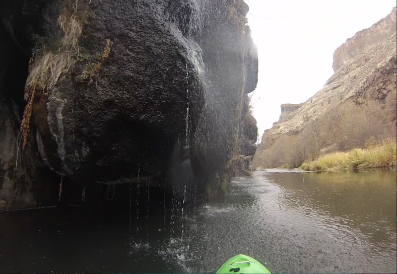
Things get easier for a couple river miles and you can hear springwater percolating from river left almost the entire run when you can't see it pouring from the cliffs.
Approaching 'The Wave' (Class IV) is flatwater with a horizon line with really only one entrance between two boulders in the middle of the river, wood accumulates to the left and right. Boat scouting the top end of the wave is possible by creeping up to the edge, but we couldn't get a good look at the bottom crux move until we got out of the boats.
At this level, we didn't see a clean line through The Wave. Normally at low flows you can drop in, stay center-right, then swing left/center to bounce off a rooster tail rock into the pool below. Today, the river crashed straight into a fence of three sharp boulders with a guard rock. There may have been a line river left around the boulders but the consequences of missing that move meant you would end up right against the fence.
The portage is simple but there is no trail, it's a boulder scramble across big rocks and a tree until you can reenter below the fence. I snapped a picture to show the fence from below, it looked even worse from upriver.
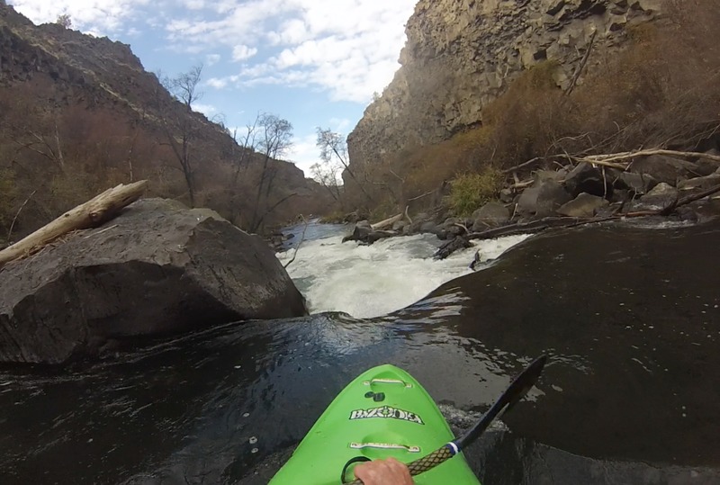
Once past the wave the river has some drops that are a nice change of pace, more elevation and deeper, with lots of play waves and fun eddylines in the runouts. Still intersperced are the short 'choose your adventure' boulder gardens excellent for eddy hopping and slot chasing.
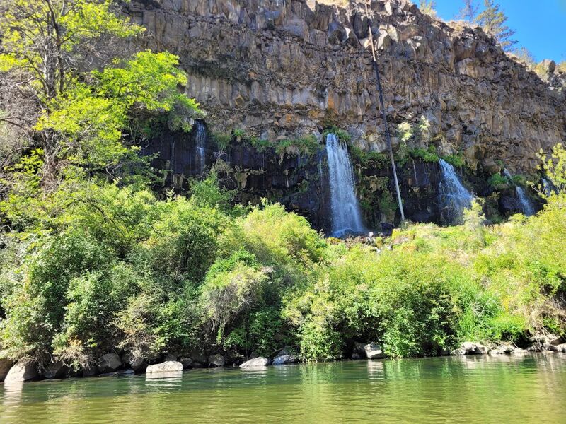
Things continue to develop into shorter but steeper drops with small boof rocks as the water becomes clearer and bluer with the addition of the springwater. As the canyon gets steeper a sweeping right turn with a drop creates a wave train that was very surfable today, and small spring outlets in the canyon wall on river left that you can refill your water bottle at (opal springs water is distributed to jefferson county untreated). A fun treat a ways into the day.
Shortly after this rapid is the 'Pink trail' takeout option, exchanging an uphill hike out for the reservior paddle for those inclined. It can be identified by a large tree and a small dirt path switchbacking away on river left.
The dam is 1-2 rapids after the play wave above, and is preceeded by deep slackwater. A sign indicates the portage. A short walk and another sign shows where to put back in next to the power plant. Feel free to refill bottles again at the various taps tied into the wells.
After you put back in, the water is much colder as lower opal springs gushes from river right. Sapphire blue water cools you off as you cruise past a couple smaller rapids before hitting the largest rapid of the run (at low water). This final rapid is deep, fast, powerful, and offers multiple lines and boofs. Take a moment to make a plan and have fun with it!
With that done, the helmet came off and we beared down for 45 minutes paddling through slackwater. When you see scum and driftwood floating in the middle of the canyon, that means the river is mixing with the lake and you should get your last cooling rolls in the fresh springwater. Once past this point (in late summer) the water temp rises dramatically and turns green with algae.
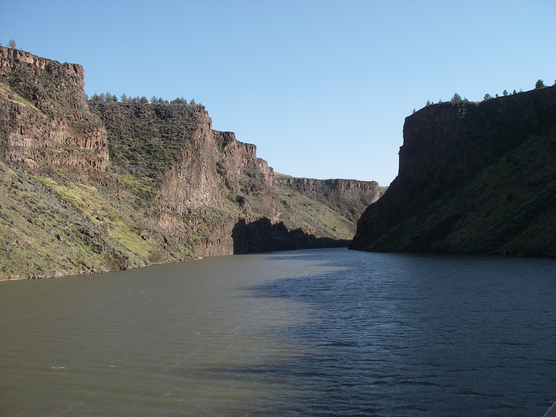
The exit contains the same beautiful canyon walls and many fishermen and skiers enjoing the lake. The takeout at the bridge has a bit of a trail directly below for jumpers and rope swingers to clamber back up, and provides a good enough path to carry boats back up to the road.
May 24, 2021
Can someone explain to me how do you paddle from Crooked River Ranch to the reservoir? There is a dam at Opal Springs and the gauge on this stretch seems to be the one below the dam. Today the one below the dam (the one used for this stretch) shows 1130 CFS and the one above the dam (which would be most of this stretch) shows 60 cfs ... things don't add up, or I am missing something?
Apr 9, 2006
Opal Springs Dam with a portage on river right. This is
also an alternate take-out as the slackwater of Billy
Chinook Reservoir is a short distance downstream, but
it requires a hike out.
Opal Springs dam includes a hydro project licensed as
FERC P-5891. Flow above is for the Terrebone gauge.
The hike out on the private road at Opal Springs is one
alternative to paddling the slackwater on Billy Chinook
Reservoir.