| Difficulty | II-III |
| Length | 2.7 mi |
| Avg Gradient | n/a |
| Gauge | Middle Fork Payette River Nr Crouch Id |
| Flow Rate as of 1 hour | 168 cfsbelow recommended |
| Reach Info Last Updated | November 12, 2021 |
River Description
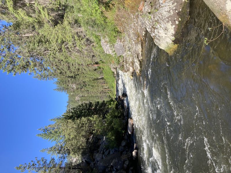
This is a fun, creek style float and is quite different from the main Payette. It is an excellent option for developing paddlers to branch out from the Main Payette for a new experience. The water is not as pushy as the larger Payette sections and the scenery is undeniably gorgeous.
WHEN TO RUN: The run is best done in the spring, while run-off provides higher flows (~800 - 1,500 cfs). Best in Late April - Early July. The Middle Fork relies totally on snow-pack and run-off, resulting crystal-clear but frigid waters.
HOW TO GET THERE: From Boise take state hwy 55 north about 32 miles to Banks. Turn left on the Banks-Lowman Hwy. Follow this for about 8 miles and turn left at the sign for Crouch. Follow this (Middle Fork Road) for about 11 miles to a bridge that crosses the Payette MF and park just past the bridge on your right side, just across from Hardscrabble Campground. Or you can putin a bit further upstream, at the bottom of 'the Steeps' drops; its roadside so you can pick a spot that looks good.
SHUTTLE: Leave a shuttle across from Tie Creek Campground or, for a slightly longer run, drive down Lightning Creek Road (a right off Middle Fork Road) about 1/2 mile and leave it near the Bridge.
THE FLOAT: There are several class II rapids and two class III rapids about 2 miles downriver. There are some great sliding pour-overs. I would not run this much lower than 400cfs. An alternative take-out is Tie Creek Campground, or a quarter mile upstream of there at a primitive camp with a dirt boat ramp. Watch for the occasional logs.
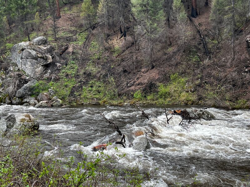
The iconic Nozzle rapid is a class 3 slide and drop (similar to Howard's Plunge on the Cabarton). You can scout it from the road on your way up, but finding the correct pull out usually takes a few tries. Enter on river left and let the torrent carry you down like a roller coaster. There are calm pools above and below to prepare or recover.
...River Features
Put In
Access PointDistance: 0 mi
OtherClass: IIDistance: 0.47 mi
The river hairpin turns around a ridge. 2 small ledge drops with pool below
The Nozzle
RapidClass: IIIDistance: 1 mi

Semi-walled out drop - can portage on right, but not fun. Rocks on river left towards bottom are undercut.
Take Out
Access PointDistance: 4.5 mi
Trip Reports
Log in to add a reportNN
Wood in river above the Nozzle - Nic Nelson
May 5, 2025
About a quarter mile above the Nozzle, there is a large tree that spans almost the entire length of the river (about 3 feet of clearance to the bank on river right). Not a fun move to get to for rafts or cats, as you have to maneuver around a large rock upstream, but a kayak can probably make it. This tree could be around for a long time.
?
Untitled
Jun 25, 2022
First taste of Idaho whitewater for us WA boys, rolled up to the Middle Fork to get our feet wet after exploring caves the last few days. The put in for the run at Hardscrabble was overrun by a group of ATV enthusiasts camping there so we put in on the other side of the bridge. There wasn't a lot of water but there was enough, keep in mind the rocks on this run are very sticky especially in packrafts. There were several class II+ boulder gardens that provided some fun slalom action and a few fun surf waves. At one point the river banks around a big right hand bend, this is an early indication that The Nozzle is coming soon. The riverbed will drop into a mini canyon and pool up for a bit above an obvious horizon line. I was able to roll up ahead of the group and boat scout on the right, there were a couple of good diagonal waves below a little flaking hole at the top in the middle. You basically just go down the middle, the left side looks relatively undercut and the right side would be a bunch of bouncy boulders but the middle is a fun chute. There were several more class II+ boulder gardens after the Nozzle that were all straightforward read and run and gave us a lot of fun lines. I'm not sure if we used the marked takeout, but our run was roughly 2.5 miles so we figured it would count if we just pulled off our car wherever the whitewater really ended. Below this is a lot of flatwater down to the south fork that we saw tubers and stand up paddleboarders on.