West River
1. Londonderry rapids
| Difficulty | II-III |
| Length | 4.4 mi |
| Avg Gradient | n/a |
| Gauge | West River at Jamaica, Vt |
| Flow Rate as of 37 minutes | 36 cfsbelow recommended |
| Reach Info Last Updated | May 1, 2018 |
The Londonderry section of the West is a pool-drop type river that is mostly visible from the Vermont 100 roadside as you drive between Londonderry and South Londonderry.
Flow Info:
In the past paddlers relied on the Corps of Engineers' Ball Mountain Lake website for the current inflow to the lake. This is no longer functioning. The West River at Jamaica has been added as a correlation. The levels listed are a guess. If you run this section please leave a comment with the level.
May 7, 2018
We ran this section yesterday (5/6/2018), which we call the Londonderry Ledges section, as a planned Berkshire Chapter AMC Trip. At the level we ran it (medium low) it was a Class 2 - 3 difficulty. At higher levels it progresses to a full Class 3 level of difficulty. It should be noted here, that the link that this AWA website provides to the Army Corp of Engineering website is not working. The Army Corp has changed their web links to dam level inflow and outflows every so often for security and hacking concerns and the current AWA link above is not working. The link that does work as of today is: http://water.usace.army.mil/a2w/f?p=100:1:0:::::# but the Army Corp has shown the propensity to change the website address whenever they detect a security threat and there is no guarantee that this link will work in future years. However if this link doesn't work in future years, just go into the main Army Corp website and drill down into the menus on dam levels and you will eventually find the new web addresses.
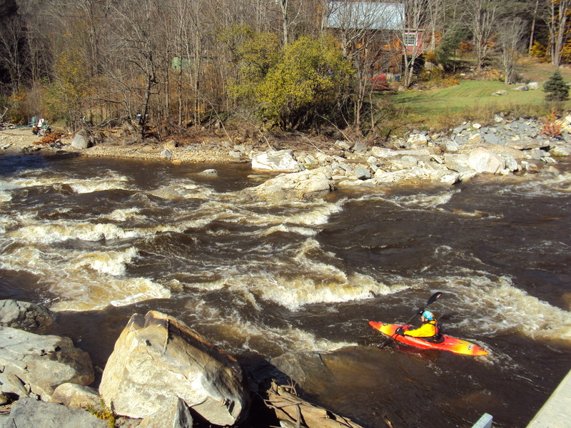
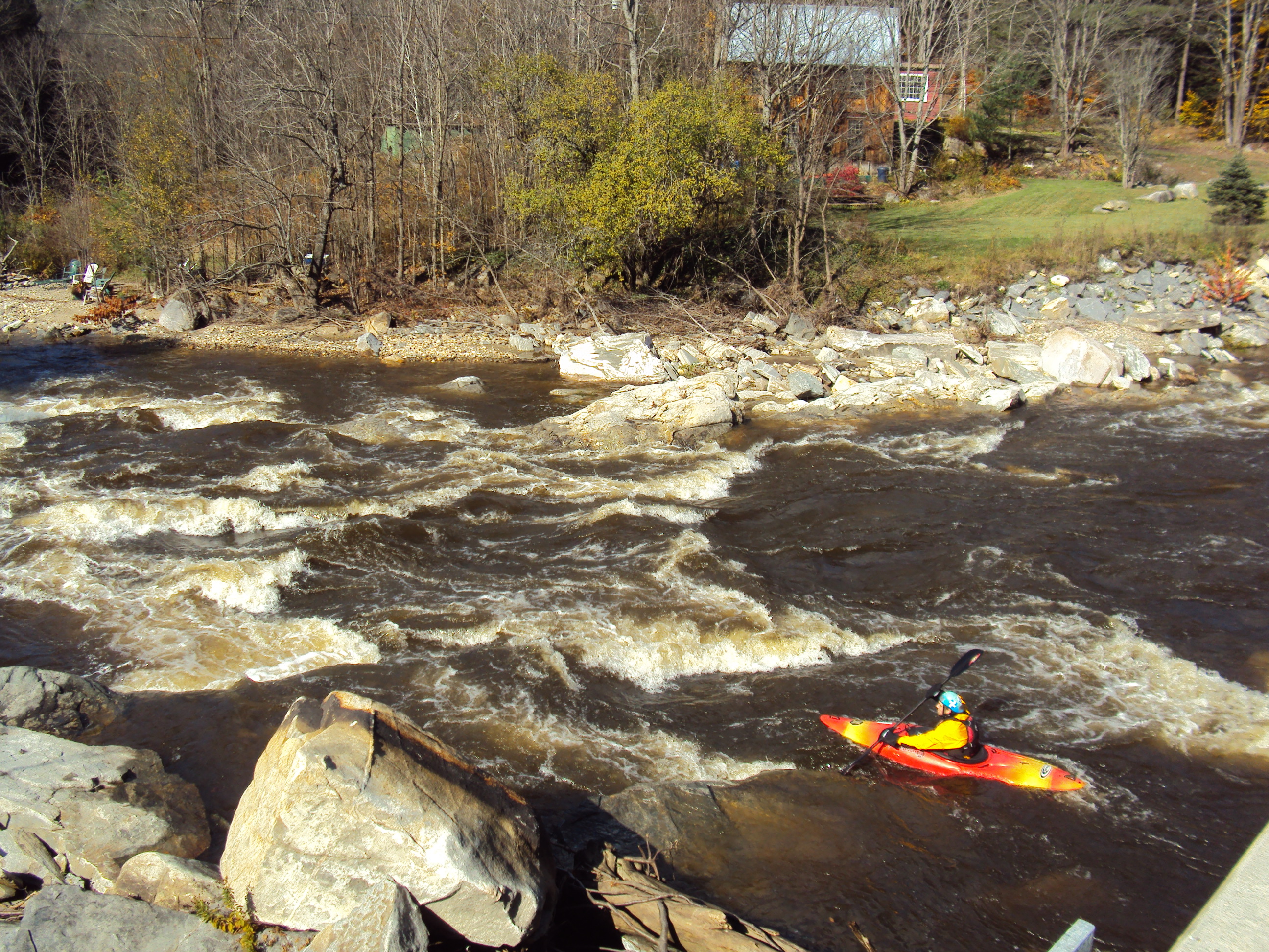
Getting back to the matter at hand, we ran the river at a level of 900 cfs as the inflow to Ball Mountain Dam reservoir. As mentioned above, I consider this a medium low level but there was nothing scratchy about the level. The river becomes scratchy at inflow levels below approximately 800 cfs and becomes increasingly more fun and consequential at inflow levels above 1200 cfs. The ledges develop holes that will stop a boat if you don't run them at the right slots.
Currently, the Army Corp on the same website page is providing a link and information about a water level gauge they are calling 'West River at Londonderry, VT'. This gauge is actually in South Londonderry and is located downstream of the take-out for this section of river and gives an almost accurate reading of how much water is flowing in the section of river that you are running. Yesterday this gauge read 475 cfs as we were running the river. This gauge is not currently listed on the USGS Gauge Website. It is only accessible at this time from the Army Corp website.
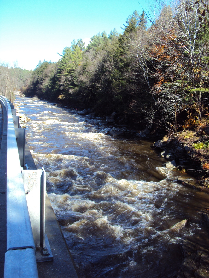
Starting the trip at the new Post Office in Londonderry, VT., there are two good rapids in this section of river. The first one starts about a third of the way into the run and begins upstream of the Rt 100 bridge that is located between South Londonderry and Londonderry proper. The rapid is lengthy and extends below and for a distance downstream of the bridge. There are plenty of eddies to catch between the ledges to plot where to penetrate the next drops.
The second good rapid occurs immediately upstream of the take-out and starts about 150 yards downstream of the Rt 100 bridge in South Londonderry. Its character is again a series of ledges. It doesn't have the large boulders mid-stream that the rapid above has, but it does have eddies on the sides from where you can plan your route(s) thru the ledges. At higher water levels both rapids become pushy and the spaces between the ledges seem too short and the ledges come at you quicker then you may like. At the level we ran it, it was not pushy and we had plenty of time and eddies from which to plan our routes.
Oct 20, 2012
I paddled this section today, from the dam in londonderry to Prouty park in south derry. I just paddled the jamaica state park section this year during the release for the first time. Just moved to the area and it was my first time on this part of the river. Nice high level. just above the south londonderry bridge there are 2 large boulders I have been watching levels on. When we put on the one further upriver was just barely submerged, for a reference. This is a really nice level on this river, not too boney, and the holes at the 'bridge rapid' above Prouty park weren't too chewy. My friend took a swim here and got beat up a bit but the holes didn't hold him or his boat. Good water for running through my new hometown. Very clean, easy to scout. Fun morning project.
May 26, 2008
i have lived on the west river for 6 years and it can be very challenging but the section talked about here is the most fun on a hot summer day on a inner tube (depending on river flow to dangerous to do most of the time) but if u want a rush do like the lpsc and grab a tube and go behind iga and tube that bad boy.
Sep 22, 2005
On September 1, a friend and I ran this section from Londonberry right below the bridge with the dam to a gravel pit in South Londonberry. The run was very scratchy, but passable with good river reading. Inflow into Ball Mountain Dam pool was 512 cfs about the time we put on and peaked at 513 cfs.