Escanaba, E.Br.
Sands Plains Run: Section 20 Bridge to W.Iron Street (2 - 8.4 miles)
| Difficulty | I-II(III) |
| Length | 7.8 mi |
| Avg Gradient | 7 fpm |
| Gauge | Middle Branch Escanaba River at Humboldt, Mi |
| Flow Rate as of 23 minutes | 12 cfsbelow recommended |
| Reach Info Last Updated | December 22, 2024 |
An excellent pool drop style run for beginners and intermediates during spring run-off -- class I-II at 'normal' water levels, class III in spring or high water. There are four short rapids in the first two miles (average run time is 45 minutes), or continue all the way to Gwynn for a few more drops, but a lot more flatwater. The drops are nicely spaced on the run and the flatwater moves at a pace which allows easy paddling from one drop to the next.
Always be on the lookout for logs which may have to be portaged.
The private land owners in the cabins have been very friendly when we've encountered them, but we have stayed in our kayaks when talking to them. Two of the cabins/houses are regularly occupied and have docks in the river.
NOTE: Our reference gauge is on Middle Branch (22.5 miles WNW), with drainage area 45.7 square miles. USGS lists a 'sampling site' very near our put-in with drainage of 96.6 square miles. Thus, on average, actual flow in this reach might be twice the listed gauge! Correlation is not assured, but is expected to be reasonably good.

A USGS sampling site lists drainage at this point as 96.6 square miles.
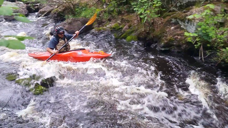
Just before the first drop, an island is encountered, though it may not be very obvious. The main flow (going into the Canyon Rapid) lies to the right -- really almost more straight ahead. You actually need to make a 90-degree left to catch the left channel. (You may also wish to check out the left side, just for variety.) A footbridge is encountered early on the left side, then a narrow channel leads to a wider ledge coming out below the island.
Shortly after the first cabin on river left (in the right channel around an island) this 30-40 yard stretch passes through granite walls about four feet apart, spanned by a footbridge. The drop consists of a slide with a bend in the middle of the rapids and a 3 foot drop at the end. This should be scouted for wood before running. Take out on the island (river left) before the drop and walk over the footbridge to inspect entire drop.
The second rapids are straightforward with a 3-4 foot drop at the end into a sometimes sticky hole. As of this writing, there is a log wedged in the rock on the right side of this run (1/2 way down) which can catch the nose of a kayak and flip it. To avoid it, stay centered or river left on this drop.
The third drop is the longest rapid on the run. Shortly after the second rapid, you will see about 100 yards of boulder bed rapids. They are fairly straightforward and end in a decent hole, great for surfing in the spring.
O'Neal Creek enters from river-right, and signals your approach to the next drop.
The fourth drop is at the end of the 'short run'. It consists of a slide through a rocky area with a 90 degree bend midway and a small drop into a large pooled area. Takeout in this pool, up the sandy bank to the local camping/party area. Or, continue on for the longer trip.
Intermittent light shoals (gravel-bed riffles and rips) are scattered between flatwater over the next half-mile.
An unnamed (as far as online maps are concerned) creek enters from river-left.
Just beyond a logged-off area, Google Maps indicates a possible ford (low-water crossing) of the stream. A brief shoals appears.
A large rock looms dead ahead, the river takes a sharp jog to the right, and trips over a short ledge as it heads back to the left.
As you round a bend there may be a ledge with likely log-jam, leading into some waves and shoals downstream.
There may be a rock wall river-left, and the river appears to be squeezed just a bit, and may trip across a couple minor ledge/waves.
May 7, 2016
Ran this run 2 weeks ago at around 240 cfs. At current levels of ~70cfs, several features appear to have created potentially dangerous hydraulics not seen at levels of ~30 cfs or ~240 cfs previously paddled. Scouting would be advisable for some of the middle drops, and portaging would be wise if you arent comfortable with the strong possibility of rolling in violent water.
Apr 19, 2016
River was a blast! Took out the whitewater boat I bought used last fall for the first time on this run. Previously, I ran this in my 14 ft touring boat at flows around 18 cfs, very boney, slow going. The melt really livened things up, creating a ton of interesting features without getting overly pushy or overwhelming for someone brand new to whitewater. Canyon rapid (both sides) and the 3rd drop in were portaged this time around, though next time I would do the 3rd drop. Canyon rapid is a bit constricted and shallow for me to think you should be running it without class 3+ skills.