Marengo
A) Snake Trail Rd (FR 194) to Marengo Lake Rd (FR 384) (6.6 miles)
| Difficulty | II-III(V+) |
| Length | 6.6 mi |
| Avg Gradient | 38 fpm |
| Gauge | Marengo River at Four Corners Rd Nr Mason, Wi |
| Flow Rate as of 1 hour | 16 cfsbelow recommended |
| Reach Info Last Updated | January 12, 2025 |
The Marengo River this high in the watershed is tiny and (at the Snake Trail Rd put-in) will appear not much more than a drainage ditch, snaking off into the alders. Why bother with such a small stream? A little over a mile and a half downstream of the put-in lies perhaps the largest 'unknown' waterfall in the State of Wisconsin.
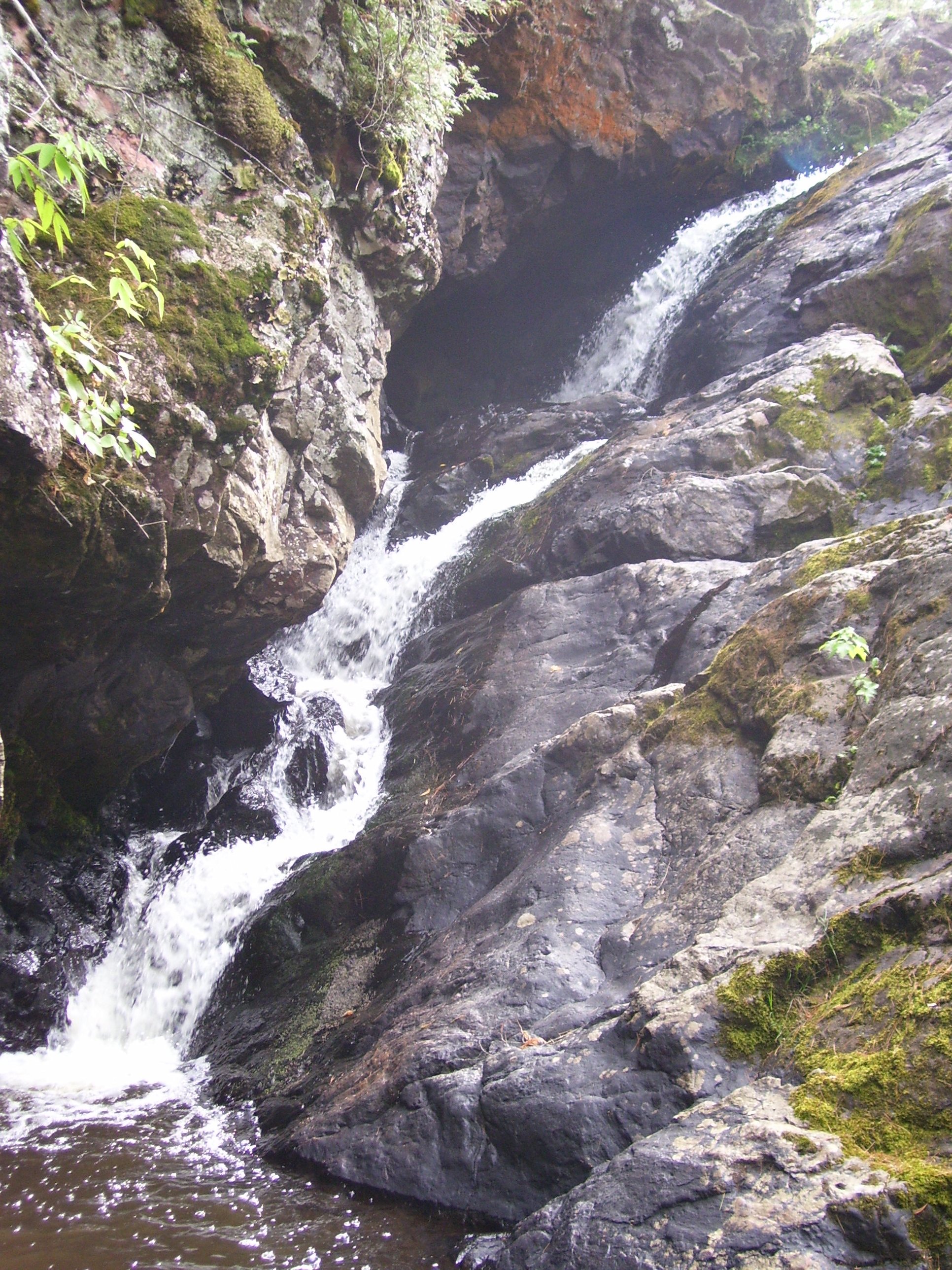
Paddle the initial mile and a half of moving water through the bushes. When the water starts picking up speed and rock rises beside the river, you'll want to exercise caution as you are in the approach rapids to Marengo Falls. The river goes to class II, then class III, then plunges 40'-50' over the falls. Parts of this may be runnable, just be certain you can stop in time. Marengo Falls is a sloping, cascading drop which is possibly V+, likely a scenic portage for most. In addition to the challenge of this drop itself, there is a tendency for wood to collect here, making running the drop out of the question.
Portage on the left down to a pool below the main drop. (The land here may be a private inholding within the National Forest so please execise respect and stick close to the river when portaging.) The pool below the main drop is just above a secondary drop of about 10'-12' which may be run, though the width of the drop may cause it to be somewhat boney. From this point the river takes off at a fairly steady class II pace with parts pushing towards class III for the next two miles until the Wisco Rd (FR 198) bridge. The maximum gradient listed above includes the falls but there is a mile in here that drops ~60', close to that max but without the drama. Be wary of wood as this is a small stream.
Wisco Road may serve as a take-out for an abbreviated run of 3.9 miles and if water levels are a bit thin, this may be a preferred course. If water is sufficient, continue the remaining 2.9 miles to the Marengo Lake Rd bridge. I'm not aware of this having been paddle
...Drainage at put-in: 12.1 square miles, but just downstream, Whiskey Creek adds 7.5 square miles, bringing the total nearly to 20 square miles.

All which follows is derived from online aerial views. There are places the river is obscured from these aerial views. As a result, this should not be expected to be a completely accurate accounting of this run, but merely a representative sampling of features and waypoints.
Aerial view appears to show a wide meander at this point as the river heads sharply right (East-South-East). It appears there may be an overflow or secondary channel which continues more Northerly, which would be a more direct route if it is passable. Otherwise, the broad loop only adds 0.1 mile. (NOTE: all distances downstream are 'main channel' routing. Your mileage will vary if any cut-offs are used.)
A meander/loop again appears to have an overflow/side-channel (in this case heading sharply off to the left) which, if passable, may cut off some distance (less than a tenth of a mile).
Up to this point, the river has been almost entirely an access paddle, flat but flowing, with the only likely challenge being occasional areas of overgrowth or deadfall. At this point, the stream narrows considerably (from the wider, somewhat swampy floodplain which flanked it for some time) and some light rocky interruptions should appear in the stream, creating at least mild rapids for the next 0.1-0.2 mile, acting as a warning of the upcoming falls.
Massive rock shoulders flank the river as it is squeezed through a slot. Scout this! (Some maps are marked with 'Marengo 2WP85 Dam' near here, presumably reference to (likely) a defunct abandoned dam which may have existed at this site.)
At the base of the falls there appears to be a pretty decent pool. From river-right, an unnamed creek (at least on maps I use online) enters as the river takes an abrupt left (WNW) turn.
After considerable flatwater, the river takes an abrupt right (North), left (WNW), then left again (South). As it does, it encounters a (very brief) low-grade rapids, bit of flatwater, then more scattered rips.
USGS lists a sampling site with drainage area 23.9 square miles.
Just downstream, immediately after a sharp right (North), the river may encounter a bit of a dike of rock creating a bit of a pinch. There may be a very brief drop/rapids. (Or not.)
No trip reports yet.