| Difficulty | IV-V+ |
| Length | 20 mi |
| Avg Gradient | 300 fpm |
| Reach Info Last Updated | April 20, 2022 |
River Description
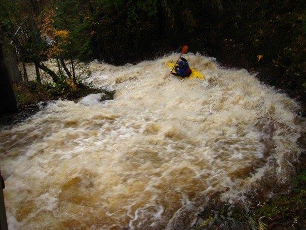
OK, I'm 'cheating' a bit here, lumping a bunch of streams together in one description/page. It seemed a shame not to have mention of these creeks on this AW river inventory, but it also seemed near absurd to detail each separately, as they all fall into a category I like to call 'stupid boater tricks' or 'micro creeks'.
Within the city limits of Duluth, there are a good number of creeks with incredible gradients and amazing slides and drops. To the best of my knowledge, most (if not every one) of these creeks have been run by area boaters.
The odds of any out-of-town (or at least out-of-immediate-area) boater catching them runnable would be quite slim. Hard-core boaters may watch for the few days (or few hours!) when they may be at 'runnable' levels, for an unbelievable 'in town' rush.
The following table hints at the variety and challenge available. (Listing is from North to South through town.)
Tischer Creek, ~1.0 mile, 400 FPM
Chester Creek, ~1.5 miles, 286 FPM
Miller Creek, ~1.0 miles, 400 FPM
Keene Creek, ~1.5 miles, 333 FPM
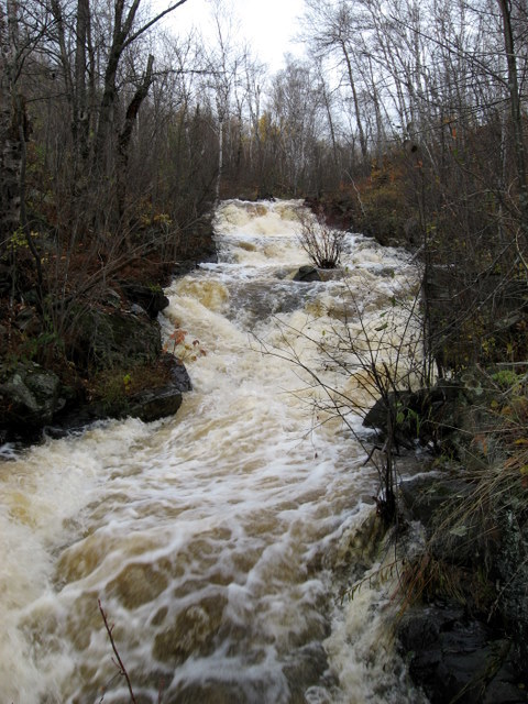
Kingsbury Creek, ~0.7 mile, 570 FPM
We would love to have first-hand reports (information, photos, videos) from anyone who has run any of these (or other 'in-town' runs around Duluth).
River Features
North End
Access PointDistance: 0 mi
The following listing is from north to south through Duluth, somewhat arbitrarily listing all distances from the intersection of E.Superiour Street and Lester River River Road (on the north end of town).
Note:
OtherDistance: 0 mi

This may not be a comprehensive list, but includes most of the creeks which have been run along with most of the 'larger' drainages.
Tischer Creek
OtherDistance: 2.89 mi
Drainage area at Superior Street is just over 7 square miles.
Steep slides and twisting turns make for a bit of a steep bobsled feel to this run.
Unknown how much has been run ... but from E.4th Street to Hwy.61 is about 0.68 miles and the creek drops 230' for an equivalent gradient of 340 FPM.
(Upstream of that, from Vermillion Road to E.4th Street, it drops 160' in 0.325 miles, for an equivalent gradient over 490 FPM, but in a heavily wooded area.
If the combine distance would all runnable, that would be 390' of drop in 1 full mile.)
Chester Creek
OtherDistance: 4.31 mi
Unknown whether there is merit, whether there is sufficient size and clear enough channel above the apparent ponds (where topo maps indicate 'Ski Jumps').
I believe most runs are from somewhere below those. In the 1.1 miles from the ski lifts (at Chester Bowl Drive Parking) to E.4th Street the Creek drops 364 FPM.
Buckingham Creek
OtherDistance: 7 mi
Is it feasible? Anyone ever done this? Add a comment or report!
Miller Creek
OtherDistance: 8.08 mi
A USGS sampling site (where the creek passes under US53/Miller Trunk Hwy near UHaul) lists drainage of 5 square miles. Another sampling site near the mouth lists 10 square miles.
From W.Skyline Parkway to W.3rd Street the river drops the equivalent of 445 FPM across 0.83 miles.
Anyone ever done this? How far up were you able to start? Add a comment or report!
Keene Creek
OtherDistance: 11.17 mi
Drainage area at Skyline Parkway is just over 4 square miles.
From there down to Keene Creek Park (below Bristol Street) it drops an average over 300 FPM.
Anyone ever done any part of this? How far up were you able to start? Add a comment or report!
Kingsbury Creek
OtherDistance: 12.17 mi
An amazing series of ledges and slides, ending up by dropping under a bridge and into the zoo! (I think you need to take-out before that!)
From the Duluth Masabi and Iron Range Railway (up near the I35/US2 interchange) down to the Lake Superior Zoo in Fairmont park, With a drainage area (at the zoo) of about 8.5 square miles, and ~330' of drop in roughly 0.56 miles, for an equivalent gradient of 590 FPM. And ... the Superior Hiking Trail provides handy scouting and carry-up to do as much of it as looks good to you!
BTW, from S.Boundary Ave to Skyline Parkway topos show 165' of drop in about 0.72 miles, which should be about 230 FPM. I hiked that once, and I was surprise to it seemed to have relatively little merit for the logistics which would be involved. (YMMV)
Anyone ever done any part of this? Were you able to run all of it? Add a comment or report!
Stewart Creek
OtherDistance: 14.28 mi
Insanely small (only 1 square mile drainage at Skyline Parkway) and steep (drops ~380' in 0.56 miles ... ~675 FPM!) before it drops underground for 0.1 mile at S.93rd Ave.West.
Anyone ever hiked this (or done this)? Add a comment or report!
Sargeant Creek
OtherDistance: 17.58 mi
Only 3.2 square miles drainage at MN23 (making it much smaller than the others), and about 65 FPM average for about 4.75 miles from where it crosses Becks Road near Skyline Parkway. Very small, likely extremely wooded.
Anyone ever look at this (or boat it)? Add a comment or report!
Mission Creek
OtherDistance: 20 mi
Generally less concentrated gradient than others around town. (So this isn't for the vertically addicted crowd, like many of the others.) Likely to encounter some areas of snags.
Put-in via a 0.7 mile carry-in from the Mission Creek Multi-use Trailhead.
Take-out either at the cul-de-sac on 131st Ave. W., or at 132nd Ave.W., nearer MN23.
Approximately 3 miles at 65 FPM average, 75 FPM max.
Anyone ever done this? Was it worth it? Add a comment or report!
South-west Extent of Duluth-Area Creeks
Access PointDistance: 20.1 mi