Blackfoot
Trail Creek Bridge to Cedar Creek (near Aldridge)(Wolverine Canyon)
| Difficulty | IV-V |
| Length | 10 mi |
| Avg Gradient | 74 fpm |
| Gauge | Blackfoot Near Shelley |
| Reach Info Last Updated | June 29, 2020 |
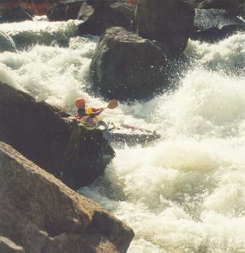
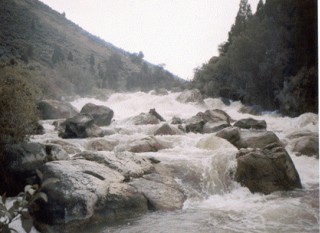
Wolverine Canyon is Southeast Idaho's premier Class V canyon. Generally runnable after most other class V sections are finished, irrigation needs allow the blackfoot to run later with warmer water than is typical, which in the heat of summer can be a bit much. I've ran this section down to 450cfs which was getting pretty boney, things can get spicey as the flows near 1000cfs. This run is fairly notorious for the dense jungle of Poison Ivy that lines the banks in many areas, making scouting and portaging a real treat. Accessing this run from some routes requires you to cross Sho-Ban Reservation land, please be considerate and treat their land with the respect they deserve. The river mostly flows through BLM property for the first few miles. When the BLM property ends, the river right bank is private property, while river left is Fort Hall Indian reservation property.
The River:
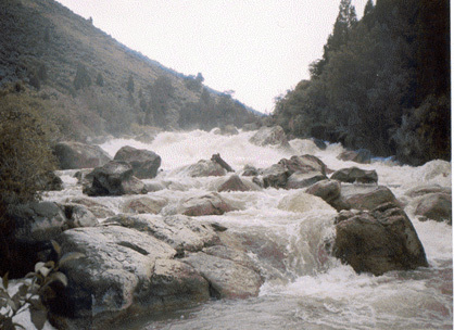
The stretch begins with a long section of meandering class II developing into class III for some miles, Moose have been known to enjoy this area so keep your eyes peeled. When you near the end of the calm before the storm, remain on your toes as the river gorge tightens and a good size pool marks the beginning of the whitewater, and time to scout.
The first main rapid, Teller Tube kicks of the excitement and is generally scouted and portaged on river right. A ledge drop leads into a flume that is punctuated by V waves and small holes, as the river passes the large boulder a quick eddy must be caught to avoid following the flow into a generally log choked constriction that has been the sight of past accidents, one fatal and quite a few near misses. So be on your toes and make your decision wisely.
A fun section of more frequent class IV rapids eventually lead into what is sometimes called the Airplane Boof. This rapid is marked by a set of boulders at the horizon line with an entrance on river right. There are a few options for running this rapid, a shallower ledge
...
The easiest parking and put ins, appear to be off a spur just upstream of this bridge or at the campground entrance just downstream. All river miles for listed rapids are from this bridge as measured with Google Earth.
A side road drops down to the river from Blackfoot River Road.
A side road leads to the top of the bluff. Trails may lead to the river.
Two river wide ledge drops give paddlers a taste of the bigger stuff to come.
The river starts dropping and within a few hundred yards the difficulty is class 4 or harder. Elevation is about 5351
This rapid within a continuous section appears to be a little bigger than the rest.
This rapid comes near the end of a long continuous section. The river bends left as it enters the rapid. Elevation 5290 feet.
After a short section of swiftwater, the channel narrows, rapids start and then split around a large island. Either channel looks fine. Below the island is a very short area of calm water heading west into one of the biggest rapids.
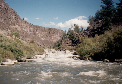
The river narrows and drops into one of the biggest rapids on the run. The channel widens in the lower part of the rapid but it is cluttered with large boulders and logs which have jammed on those boulders. Elevation at start, 5230 feet.
This cluttered rapid is the last hurrah for the continuous rapids above. The river eases off for a ways below this rapid.
Two big cluttered rapids are separated by a short pool.
This long congested rapid is on a gradual left turn.
Calm water flows around an island, then into the congested entrance to one of the biggest and longest rapids on the run. The river drops 104 feet in the next 1/2 mile which is the steepest section of the run. A tenth of a mile after that, the serious whitewater is over. Elevation at entrance is 5000 feet.
The river bends northeast to go around a promontory across from Cedar Creek. The first rapid is a narrow, straight chute leading into flat water of a horseshoe bend. This rapid is about 80 yards long.
Cedar Creek comes in from river right at a horseshoe bend. A fairly easy rapid, starts at the mouth of Cedar Creek and leads out of the horseshoe bend.
If you take out here, beach on the upstream side of Cedar Creek, above the rapid. Carry up the creek a very short distance, cross the creek, then follow use trails up a steep hill to Blackfoot River Road.
Elevation at the river is 4796 feet, while the road side parking elevation is about 4970 feet.
A steep road or trail drops down the cliff to near the river.
The river is flat and meandering in this section, but it appears to be swift with plenty of waves.
A well used spur road drops down to the river.
Apr 7, 2012
I have paddled this stretch several times in the last couple of years and would agree with what Davis wrote, class 4-5. If you don't know what that means than simply stay home. Greg's group did this run in 6 hours with no previous experience, that's not at all bad for a solid run like this.
I consider it one of the best runs in the area and contradicting what others have written I think this run is relatively clean. Yes there is some wood, but not very much considering what most class 5 gathers. Teller Tube is a very straight forward but committing rapid with some wood at the end where you wouldn't want to go even if it was wood free. There are dozens of good drops and only one mandatory walk, that's a rarity on this type of run. Also, it flows late season which is a huge bonus around here!
Important side note, I believe that this gauge was discontinued from USGS. This reading on the AW site is old and not accurate. You can call irrigation at 208-238-0586 for current flows. If somebody knows of a working internet gauge please post it.
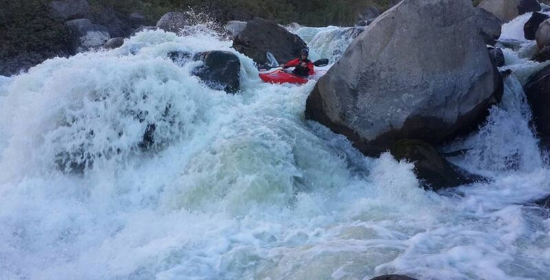
I just paddled the Wolverine Canyon section of the Blackfoot for the first time yesterday. I read AW's write-up after the fact and would like to offer an additional warning. We padded the river at 550 cfs without incident, but it is a very dangerous and remote river. Neither of us had done it before, and it took nearly six hours to scout, run and portage when necessary. We portaged three times, and the rapid called Teller Tube was not one of them. There are numerous places to pin, broach and otherwise get in a lot of trouble. The Class V rapids are interspersed with very consistent and bony Class IV rapids that are not like what Idaho boaters are used to. They are creeky and rocky rapids. Even with thorough scouting I broached three times and pinned momentarily at least twice.
The combination of remoteness, poison ivy, rattle snakes and very demanding scouts and portages makes this river very dangerous. The rapids are steeper than anything on the North Fork Payette, although they may be a smidgen easier. But the consequences for ever coming out of your boat are severe.
Had we gone with a guide, I imagine it would have been a smoother day. But even with a guide there are many places where scouting is crucial. This is a unique run in Idaho. It's worth doing, but be prepared, and, as Gordo pointed out, don't go in there unless you've got your A game. It's not only difficult whitewater, but it's a physically-demanding day.