Merced
0.5) Headwaters to Little Yosemite Valley(Little Yosemite Valley)
June 30, 2026
| Reporter | Josh Thiem |
| Flow | Medium Flow |
I’ll start off bluntly, the ratio of hiking to paddling is not very good for this run, don’t expect an upper cherry where you get the hard hiking over with and then are rewarded with days of good kayaking, there’s a lot of hiking and portaging, before the run, during the run, and after the run. Our flows were about 250 and we felt that in packraft it was good medium flow, in a hardshell you could definitely go higher, but then you’ll be doing a minimum of 20+ miles of hiking with a hardshell.
We started the day bright and early on Saturday at the Tuolumne Meadows wilderness permit station, the station opens at 8:00 and we arrived at 7:30, first in line. By 7:50 there were a dozen people behind us, so make sure to arrive early. We happened to get a walk in permit for Rafferty to Vogelsang, the desired permit, but also didn’t see a single ranger the whole trip. Also note that this permit includes Half Dome if you want, but you must camp at least one night between Tuolumne Meadows and Yosemite Valley for it to be valid. You can’t use it to hike from the valley up.
Then from there we stated the long hike to Merced Lake. It is 14.7 miles from the trailhead to the lake and that includes going up and over a 10,100 foot pass then down to Merced Lake at about 7,150, with some added uphill on the way down. It’s also not a gradual downhill, it goes steep then flag then steep on repeat, not the most ideal. In total it took us over 10 hours to reach Merced Lake with blistered and tired feet. My advice is take two days to do the hike in, it’s a very scenic one, but alas we had time restrictions. There’s also a mile+ long runnable slide on fletcher creek that can shave off some hiking time, but wood can jam up the pool and once you’ve scouted the bottom you probably won’t want to hike back up. It would also go much better in a hardshell.
Once at Merced Lake we had a very nice rest and prepared for the next day. There are runnable rapids on the Lyell Fork above Merced Lake, but you want higher water than what you want for the lower section. There’s also a rapid right at the (now abandoned, which means no toilets) Merced Lake High Sierra Camp, which we named Lil Dink cause it looks like a Dinkey Creek rapid. However, there are several log jams between it and the lake, prompting us to just set up our packrafts and go straight to the lake without portaging.
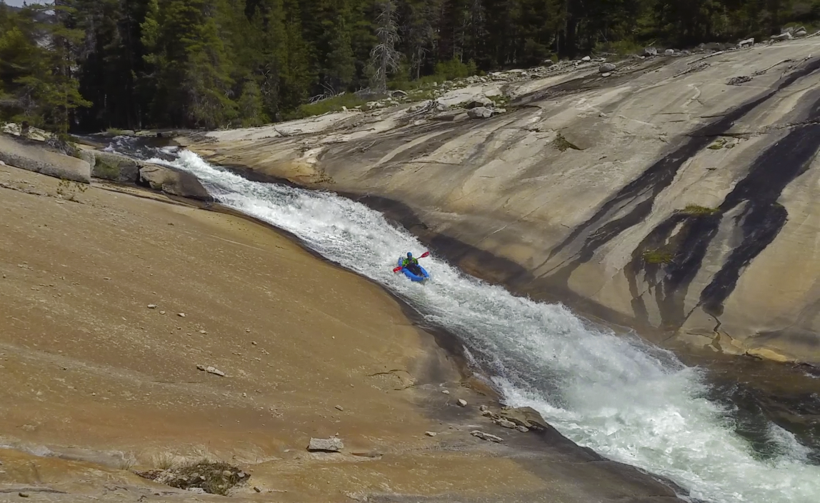
The paddle across the lake, like everything on this run, is very scenic, and took us about 15 minutes. From there it’s game on right away. As soon as you exit the lake there’s the first of many clean granite slides. As I soon learned, all of these slides end in formidable holes. As is be nature of the run, it’ll go big granite slide, then end in a river wide weir hole, some bigger than others. A hardshell should have no problem skipping over them, but packrafts don’t boof as well, especially my one that developed a hole causing to be constantly deflating. From here id the best rapids of the run, clean big granite slide after big clean granite slide, including one cool mini-gorge. There was one log jam portage in a mank rapid, but otherwise very clean. It ends in a very large slide that splits in two at the end, and I somehow ended up on the island between the two.
Bellow the slide the river meanders a while with some log jams and mank rapids. Then after a while you’ll see a bridge where the trail crosses to river left, this is the gorge you’ve been worrying about since the hike in. With a punctured packraft and a very ugly (unrunnable log jam) entrance, we elected for the high and to the left route. The portage is a bit longer than a mile and has some serious elevation, imagine portaging cherrybomb. The gorge itself is plagued with having a couple really good rapids then a really ugly one right before or right after, and no real good way to get in or out of the gorge, or even portage. There’s many good clean rapids in there, it’s just a challenge to reach them.
Once bellow the gorge is another fun double slide, then some mank. You’ll see a bridge where the trail goes back to river right, get out here, we didn’t and a had a world a hurt getting back to the trail. This is the start of the next gorge and it’s very hard to scout/portage unless you get on the trail, and it’s much much much easier to do at this bridge than 3 mank rapids bellow it. This gorge has some stout shit in it, notably a 30 foot tall double water fall with a gnarly rapid directly above it. It can be done in hardshells, but would be pushing our packrafting capabilities. After really not very long the gorge opens up with the Bunnel rapid, a 50 foot tall slide with a 8ish foot tall vertical drop lead in. The slide then ends in a formidable river wide weir with no easy escape, so keep your speed up.
From here the river meanders a while with some flag water, mank, and oh so many log jams. Eventually though it ends in the best (and last) rapid of the run, a giant 50+ foot tall slide that skips you out an incredible amount. There’s even a fun boof and mini-slide lead in. On the actually slide go right of the rooster tail then keep it straight and launch the end. Bellow here is some mank then a couple miles of flat water through Little Yosemite Valley. We elected to camp at the Little Yosemite High Sierra Camp (which did have working bathrooms) and then hiked out Monday morning. There’s two options for the hime out, the John Muir Trail which is wider and less steep snd absolutely the call for hardshells. And the Mist Trail, a mile and a half shorter, but much steeper, and especially bellow Vernal Falls, narrow. And the closer you get to the valley, the more people there are, and there’s a lot of people. It took us more than 4 times as long to get from the top of vernal to the bottom as it did to get from the top of Nevada to the bottom. The endless conveyor belt of people on a narrow rock staircase made going down a substantial problem, especially with an extra large pack from carrying paddling gear. And expect to be stopped and asked questions frequently. Then once at the car it’s an hour and a half one way for shuttle. Also do them a favor and pick up some PCT hitch hikers trying to get back to Tuolumne Meadows.
While I’m glad I went, I’m not itching to go back. I would love to do it in a hardshell, but the amount of effort that would take would be monumental. All in all we went about 30 miles in two and a half days, the vast majority being hiking, not paddling. You’re doing the run for the scenery and a couple fun slides in the middle, not for the whitewater.