Green
2. Big Hungry Creek to Fishtop Access(Green Narrows)
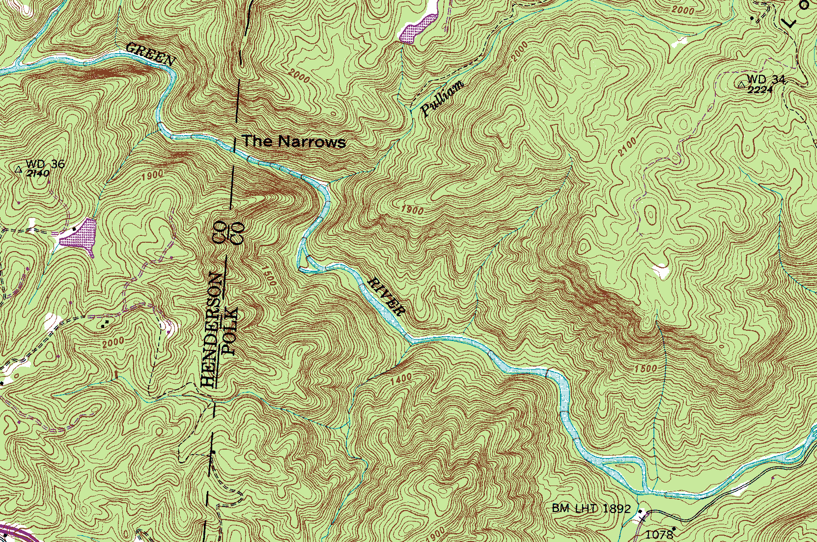
<br>Above is a section of the USGS topographic map showing the Green Narrows. The contour interval is 20ft., and the Narrows as a run is said to be 2.88 miles long. Although no actual scale is shown above as I had to leave that part off the map, from the county line to Pulliam Creek is exactly .3 miles by accurate measurement. Conveniently, a viewing of the Polk County GIS aerial photo shows the county line to be crossing the Green precisely where the log is in Go Left. To see the whole map above, go to this <a href="http://libremap.org/data/state/north_carolina/drg/">Libre Map Project</a> page for North Carolina, scroll down and open the "Cliffield Mountain" quad map. <br><br> <b>Tributaries</b><br><br> <i><u>Big Hungry Creek</u></i> is the largest of anything feeding the Green (Upper or Narrows) and pays tribute to the Green (from the North) at the beginning of the run, as shown in the top left. With enough rain, running Big Hungry is a fun way to get to a high water Narrows float trip, <a href="http://americanwhitewater.org/content/River_detail_id_3862_">and right here</a> is the AW page.<br><br> <i><u>Johnson Branch</u></i> is the mini-trib that feeds in from river-right immediately below "the drop below Frankenstein". Although it is not labeled on the map above it appears on the 1906 engineering drawings un-earthed from the UNCA archives. We've started calling that rapid "Johnson Branch" as a result of this discovery.<br><br> <i><u>Pulliam Creek</u></i> drops steeply into the gorge at Groove Tube and is the namesake for the Pulliam Creek Trail -- the main hiking route in or out.<br><br> <i><u>Camp Creek</u></i> comes in from river-right after the first long stretch of shoals below Sunshine, as the river bends to the left. Although fairly small, with hard rain in the right place this trib can really rock -- and has been known to provide a 2-3 inch "Camp Creek Bumper" for the rest of the run-out down to Fishtop. <br><br> <i><u>Bear Branch</i></u> A couple hundred yards down from Camp Creek is a micro-sized branch on the left. It's named on some other maps, but not on the topo map.<br><br> A little ways down from Sunshine the topo map shows the river splitting with an island in the middle. That upper channel is a dry stretch of riverbed now, beginning around the rapid "Triple Cracks". The Green River Cove Trail heads downstream from here, on river-left. Another one of those dry channels begins at Frankenstein on river-left, but it's much smaller and didn't make it to the map. <br><br> <b>Trail Map</b><br><br> This is the <a href="https://www.americanwhitewater.org/content/Photo/detail/photoid/889222/">best trail map</a> for the Gamelands trails. Here is another <a href="https://www.americanwhitewater.org/photos/archive/medium/886999.jpg?no_cache=76740001">trail map</a> to the Gamelands. And here is <a href="https://www.americanwhitewater.org/photos/archive/medium/887000.jpg?no_cache=89870001">yet another</a>.<br> <br> Detailed hiking directions are <a href="http://www.americanwhitewater.org/content/Photo/detail/photoid/18109/">found here</a>. <br><br> <b>Google Road Map</b><br><br> With the pin placed at the Pulliam Creek Trailhead, <a href="https://maps.google.com/maps?f=q&q=35.290540,-82.328069+%282362+Big+Hungry+Rd,+Saluda,+NC+28773,+USA%29">right here's</a> your road map.<br><br> <b>Historical Map</b><br><br> Below is a neat old (but un-dated) map taken from a UNCA archival website called <a href="http://toto.lib.unca.edu/findingaids/mss/speculation_lands/items/slc0766.htm">Speculation Lands</a>. Although the exact date this map was drawn is unknown, it was well before Route 26 went in, when the option was "Howard's Gap Road" (sic), and before Lake Summit was created by building the dam (~1921?). It was drawn after the railroad tracks were installed at the top of the famously steep Saluda Grade in 1878. So all that can be said for sure is that it was between 1878-1921, and most likely was related to some early engineering surveys completed in 1906 when a few <i>extra</i> dams were being considered (see below for a link to "The Ladshaw Plan").<br><br> <img src="http://www.americanwhitewater.org/photos/archive/medium/50387.jpg?no_cache=85300018"><br><br> This link <a href="http://www.americanwhitewater.org/content/Photo/detail/photoid/50387/">right here</a> takes you to the stand-alone AW page for the map above.<br><br> <div style="border: 1px solid black; padding: 0.25em; background-color: rgb(217, 228, 238); margin-bottom: 5px; margin-right: 185px;"> <p style="padding: 0.1em 1em;">As an aside, on December 12th of 1906 a pair of overly ambitious civil engineers from Spartanburg, SC (Ladshaw and Ladshaw) <a href="http://toto.lib.unca.edu/findingaids/mss/speculation_lands/items/slc0081.htm"><i>proposed building four dams</i></a> on the Green instead of the one we have today, and used a name apparently common at the time -- "Fish Stop Falls" -- for the rapid we know as Hammer Factor. Friends, let us rejoice that their plan was not chosen. Two large scale detailed blueprints showing the locations of the four dams, penstocks, powerhouses, and roads can be viewed in the UNCA archives and are well worth the time if you are interested. Likely evidence that the above map is connected to this proposal is found in this just earlier <a href="http://toto.lib.unca.edu/findingaids/mss/speculation_lands/items/slc0165.htm">Ladshaw letter</a>.<br><br> One more thing: it turns out that "Ladshaw Day" is being turned into an annual national holiday....<a href="http://www.americanwhitewater.org/content/Photo/detail/photoid/882903/">as described here</a>.<br> </div> <br><br> <b>GIS Map</b> Here's a scalable, zoomable, <a href="http://explorer.arcgis.com/?open=94d218d543064d42bbdcacf6b7097b63">GIS map</a> of the area that might be helpful.<br><br> <b>Gradient Diagram</b><br><br> Below is a diagram of the gradient on the Green Narrows made by Chris Bell. This chart can be compared to those of other whitewater runs in WNC <a href="http://www.boatingbeta.com/compare_noframes.htm">here</a>.<br><br> <img src="http://www.americanwhitewater.org/photos/archive/medium/18604.jpg?no_cache=34940001"><br><br> <b>3D Relief Map</b><br><br> This is a great look at the gorge courtesy of Rick Lockamy. The bottom of the picture is a little upstream of Fishtop, and Pulliam Creek comes in from the right side of the frame maybe a 1/3 of the way up. Interstate 26 is visible as a light colored ribbon in the top left. <a href="https://www.americanwhitewater.org/content/Photo/detail/photoid/882847/">AW page for this relief map</a>.<br><br> <img src="https://www.americanwhitewater.org/photos/archive/medium/882847.jpg?no_cache=74360001"><br><br> <b>Outline of the Green River Gamelands</b><br><br> Also from Rick Lockamy, here's an map showing most of the properties that make up the 14,000 acre Green River Gamelands.<br><br> <img src="https://www.americanwhitewater.org/photos/archive/medium/882899.jpg?no_cache=3720001"><br><br>
(1) USGS.....(2) Some Old Guy.....(3) Chris Bell....(4) Rick Lockamy
A bunch of squiggly lines
n/a
All your favorites