Blackberry Creek
Jaycee Pond Park (PnP)
March 21, 2021
| Reporter | Daniel Murphy |
SCOUTING REPORT: Blackberry Creek, 3/20/2021 around 1pm, flow about 70 cfs. The Fox was about 3000cfs. This location was scouted as a potential beginner teaching venue, and was my first time here. As described above, this venue consists of three rock-arch dam drops followed by a ledge drop under the River Road bridge. Each feature is about a hundred yards downstream of the one above it, making it very pool-drop. Each drop was about 18-24 inches total drop across the feature.
Above each of the rock arch dams the water appeared deep enough to get good purchase with the paddle blade. The current seemed slow enough that a boater would be able to paddle upstream above the dams. Also, these pools would provide plenty of time to recover a swimmer and equipment.
Below Drop #3, the water was visibly shallower, and some scrapping/contact with rocks is likely, but there were channels through which one could maneuver. The shallowness would preclude getting good purchase with a paddle blade, so attainment would likely be challenging.
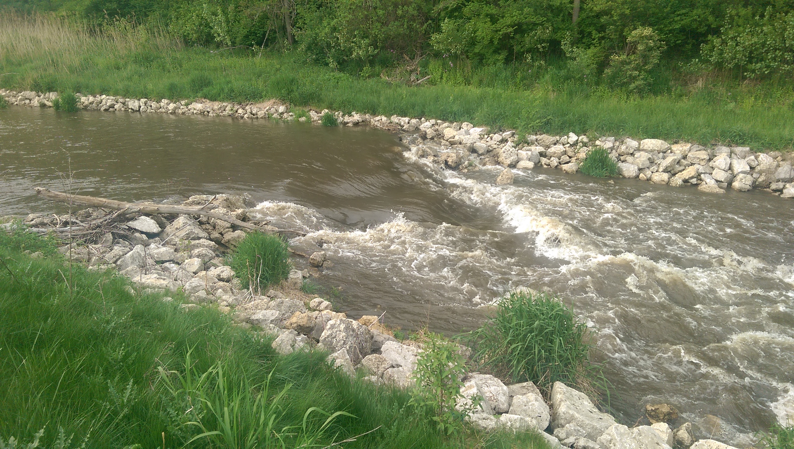
The first drop had a tree across its entire width, making it impassable. It is not likely it will wash out without a high-flow event. Otherwise, it appeared to have just enough water to navigate with some minor bumping and scrapping. There would have been a nice downstream “V”, as in the pictures, but for the tree.
Second drop also had enough water that one could paddle it with a little bumping and scraping, but it also had a tree in it, this one aligned with the current. A paddler could run the “V”, the outfall of which lined up with about a boat width tongue of water between the tree and a rock. However, any maneuvering error could result in the paddler becoming impaled on the tree.
Third drop did not have a very discernable “V”, as did the previous two drops; it was more shoal-like and boogey-waterish, but again could have been navigated with a little bumping and scraping.
Downstream of Drop #3 the channel was noticeably shallower. A paddler would have to pick his or her way downstream around rocks to the ledge under the bridge. River left there was a tongue of thru water and a large eddy. In the middle, the water poured over much like a low head dam, but the boil was only about two feet or less; one should be able to paddle through it. River right was shallow, shoal-like and boogey waterish. A paddler told me when the Fox is around 4000cfs and the creek is on the order of 400-500, a very nice wave forms at this spot.
The paddle out to the Fox appeared to be shallow, similar to the channel between Drop #3 and the bridge. Once on the Fox, attaining to Marge Cline would be a challenge for even a strong paddler at most flows. One will have to decide to paddle out or carry up. Consider this when choosing where to park your car.
Summary: Absent wood in the features, I would likely use this location as a teaching venue down to today’s level, 70 cfs. Not sure what the upper limit would be for beginners. Very new beginners may also find the location useful in developing eddy-work and ferrying skill, but skilled paddlers would likely find the venue unchallenging.
Put In: The creek can be accessed from the public land surrounding Jaycee Pond, as shown on the map. There is a small parking lot on the North side of the pond. Walking around the pond’s West end...you don't need to go through it… you can access directly Drop #1 and Drop #2. Drop #3 and be bridge below can be accessed by walking to the Easternmost part of the public land, then cutting through tall brush and stickers and walking along the quarried rock shoreline. The walk back upstream from the bridge and Drop #3 was somewhat of a chore just hiking it. It would obviously be more difficult, but possible, carrying a boat and equipment.