Sprite Creek
Stewart Landing to Youker Road
| Difficulty | III+(V) |
| Length | 4.5 mi |
| Avg Gradient | 90 fpm |
| Gauge | Sacandaga River Near Hope Ny |
| Flow Rate as of 1 hour | 73 cfsbelow recommended |
| Reach Info Last Updated | April 21, 2016 |
Directions to putin:
From the NY Thruway (I-90), take Exit 29A. Take NY 169 toward Little Falls, and then quickly grab NY 167 toward Dolgeville.
In Dolgeville, grab NY 29 N toward Salisbury Center for about 4 miles.
Bang a Right onto Rte. 29A/130 (Emmonsburg Rd.) East toward Emmonsburg. After about 4 miles, morph onto Rte. 119 East.
After about 3 miles, bear Left onto Stewarts Landing Rd. It's about 3-4 miles to the dam.
Walk along the trail and put in downstream of the concrete abutment.
To takeout:
Head back on Stewart Landing Rd. and onto Rte. 119 West.
After about 2 miles on 119, head Left onto Kelly Rd.
After a mile, take your first Left onto Youker Rd. Head about a mile upstream, and park at the turn-out. If you have any doubts about finding the takeout from the creek, walk down the trail to see whether anyone's tied anything onto a riverside tree there.
The lat/longitude coords are approximate, from TopoZone. This is a very narrow creeky run; the consensus seems to be that it's mostly class III with a couple of V's (one of which has serious pin danger) sprinkled in. The release comes out of Canada Lake for the fall drawdown.
Put in at Stewart Landing and take out near the bend on Youker Road, about 3/4 mile downstream of the old substation (which is private property, by the way, completely off-limits). Walk a couple hundred feet from the road down to the river to note the location of the takeout.
Mile-by-mile gradient below Stewart Landing: 130, 30, 120, 100, 30 (0.55 mile). A mile that drops 130 feet sounds pretty hefty, and so does the other that drops 120. Note that this gradient seems to have some partial-mile sections that are significantly steeper than 130 ft/mi. Exercise caution!
Here's a lot of beta courtesy of Brianf, of the Northea
...Put in at Stewart's Landing Dam. There is a parking lot right at the put in overlooking the lake and dam.
If the clamshell (tainter gate) is open you can put on the lake and paddle through it. You will rocket down into some turbulent water with a very large recirculation eddy on the left. Stay with the flow you're in on the right side and move back center as the pool narrows and picks up gradient.
When it is closed you can walk a little down Stewart Landing Rd and take a small unmarked path to the river. It is very soon and hard to miss. If you find a larger marked trail you went too far and need to work your way upstream as you walk to the river. Put in next to the concrete wall as far up as you can go.
Before the 119 bridge there is a drop with a good boof. After you go through the old bridge abutments you can catch an eddy on river left, or slightly further down on river right to set up. The boof is in the center left, you want to be a little left of the curler coming off it to the right. If you don't feel the boof you can run down the right side.
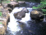
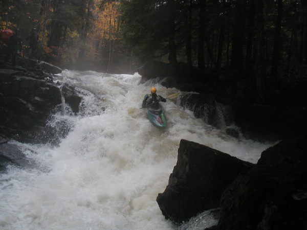
The boof rock is used as a gauge since it can be seen from Route 119. The photo of the drop shows what a lower runnable level looks like. This was during one of the draw down releases. Everything was fluid but you could get hung up on rocks in spots if you don't pay attention
You can tell you got to The Slide when you get to a spot where the river is divided into two 'channels' by a small rocky area with small shrubs above a flat pool with a horizon line. The horizon line is formed by a 3-4 foot ledge. Boof the ledge on the center right a little to the left of notch in the ledge, trying to be perpendicular to the ledge. After going over the ledge the river collects in a pool and makes a hard left turn. You can stop in the pool to collect your group or get out on the flat rock and take a look at the slide. Enter the slide center right and move to the left as you go down it and punch the reactionary at the bottom. The lead out of The Slide is a small boulder garden. The water in it should be pushing you to the right. Be prepared to catch the eddy on the river right as its the last eddy before Triple Drop.
Triple Drop is one of the big drops on the run. The flow divides around an island giving you two options on how to get down. Typically people run the left channel. The right channel can be run but there is a crack in the rock that flow goes into which you want to avoid.
As you approach from The Ledge, ferry from the river right eddy, across the current, to the river left eddy. From this eddy you can scout the left channel or portage. The left channel consists of three ledges in short succesion, two 4 foot ledges then a 10 foot drop. Start working your way down on the left. The first ledge is at 45 degrees to the flow. You want to wait til you've passed the guard rocks to boof off it to the right. Preferably you'll be torwards the top and able to catch the river right eddy below the edge. This is a good spot to stop and set up for next two ledges. From the right move back to the center and keep a little leftward angle as you boof off the second ledge. You have about 15 feet of quick water into the final part of the drop which is about 10 feet. Continue moving from center to the left side. There is a submerged rock wall on the left that is parallel to the flow. You want to be next to it on the tounge of water boofing off the left side of the ledge. The landing zone is narrow, but if you get it, you won't hit anything. You should land so that you are going just to the left of the rock in the outflow.
Two Beer Bridge is where you take out if not running Wild Child, or if running it you could walk back up. It is the footbridge before. Locals have put up a sign at it with its name and all know it as Two Beer Bridge. To go all the way down to the bridge you will need a 4 wheel drive vehicle. For most it is best to park after you have passed the very large puddles which may require a vehicle with good ground clearance, before the road goes downhill. The final bit of dirt road is steep with large rocks.
When approaching Two Beer Bridge on the water make sure to catch an eddy so you don't get swept downstream. The first option is a larger eddy on river left as the water picks up gradient. If you're not feeling confident it is better to take out here. The next option is to catch the river right eddy before the bridge abutment. There are guard rocks that need to be negotiated to get into it, making this a harder option.
Immediately after Two Beer Bridge is Wild Child. This is manky sliding drop as the river makes a turn. In the landing zone there is a hole and a boulder, making a room of doom on the left side. Many choose to skip this and take out beforehand.
Nov 17, 2011
'Magic Hat' is simply the name of a good micro brewery.
Oct 17, 2004
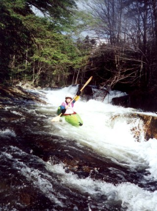
This is the drop right after the foot bridge.
We chose to boof off of this ramp rather than take our chances sticking the landing between the rocks on river left. I suppose that makes us wimps.
Oct 15, 2004
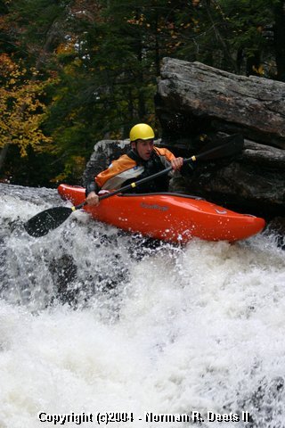
Jim leads off with a strong boof of the flake on the river right route.
Jan 1, 1900
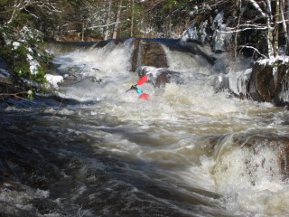
Old photo! The man in the shadows is non other than Pete Skinner, river advocate and former AW Director. There are not many photos in existence that show Pete standing still. This photo is at the end of the first set of ledge drops, where some have pinned in the crack. To avoid the pin, launch off the flat rock angled slightly to the left.
Jody at the beginning of the series leading into the drop in photo 1082. There are 4 separate and distinct rapids here closely spaced together.