Cumberland, Big South Fork
1. The Confluence to Leatherwood Ford
March 20, 2015
| Reporter | Watts Hudgens |
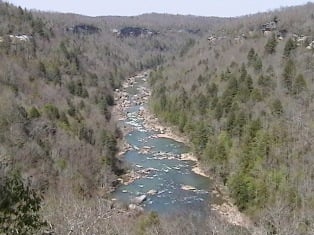
On Thursday we launched from Burnt Mill Bridge to Leatherwood. A mixed group, from Canada eh? , of canoes and me in my kayak. Half of the group stopped at the Confluence and hiked out to the car parked on the road past the Scott County Airport. The kayak and two open BlackFly canoes went on downstream. Matching post for Clear Fork section exists. Level was about 1800cfs which was lower than what I usually see on this section (2000-3000cfs more typical for me in the past). We enjoyed the heated changing-room at the takout, but noted the set of stairs leading from the high-water line at O&W Bridge as a possible takeout in the future to avoid the 2 miles from OWB to Leatherwood Ford. From the confluence it's approx 3/4 mile to the first of the big three and that 3/4s mile is mostly straight. When the river first starts to turn back to the left, below the Confluence, is where Double Drop is getting close. Scout from river right. We had more room for the larger canoes in a higher eddy rather than the eddy that I normally scout from in my kayak. The first drop was fine, center or slightly right of center into the boiling funny-water before the second drop. We ran the second drop angled towards the massive boulder pointing our bows river-left to square-up to the curler wave coming off of the boulder. One canoe flipped and we separated swimmer from boat in the pool to keep him away from what appears to be a sieve just downstream. Washing Machine gave us no trouble. Scouted the El from a taller, large boulder in an eddy upstream and then also walked downstream on river left to get a better look at the curler on river left side of the maw of the hole. Boat-scouted the rest of the river. Decent surfing waves for my Nomad8.5 in and below The Narrows.