Cumberland, Big South Fork
3. Station Camp to Blue Heron, KY (19 miles)
May 17, 2003
| Reporter | AJ Woodworth |
I have canoed the BSFCR from Leatherwood to Blue Heron the last 2 years, every memorial day, and plan to until my last breath. It is a truly spectacular river, flowing in throughout a gorge with steep, tree-lined banks and feisty whitewater.
The run begins at Leatherwood, and is about a 1 mile strech of Class II whitewater until you hit Angel Falls, which is in my belief, a serious Class IV. One person dies every year on avearage in that rapid, so use extra caution. The tricks to doing it are 1) DONT PANIC! and 2) Hard, serious turns after the 1st boulder that forks the flow at the entrance to the main run. Make sure you dont flip in the Class II entrance rapids, and if you do, make a quick swim to the bank, and forget about the boat.
After Angel Falls, the river turns into a virtual lake. A few Class I riffles are there to keep you from dying of bordem. I recommend you set up camp about 2 miles past Angel Falls, so you get enough rest to paddle strenuos dead water after that 1/4 mile portage.
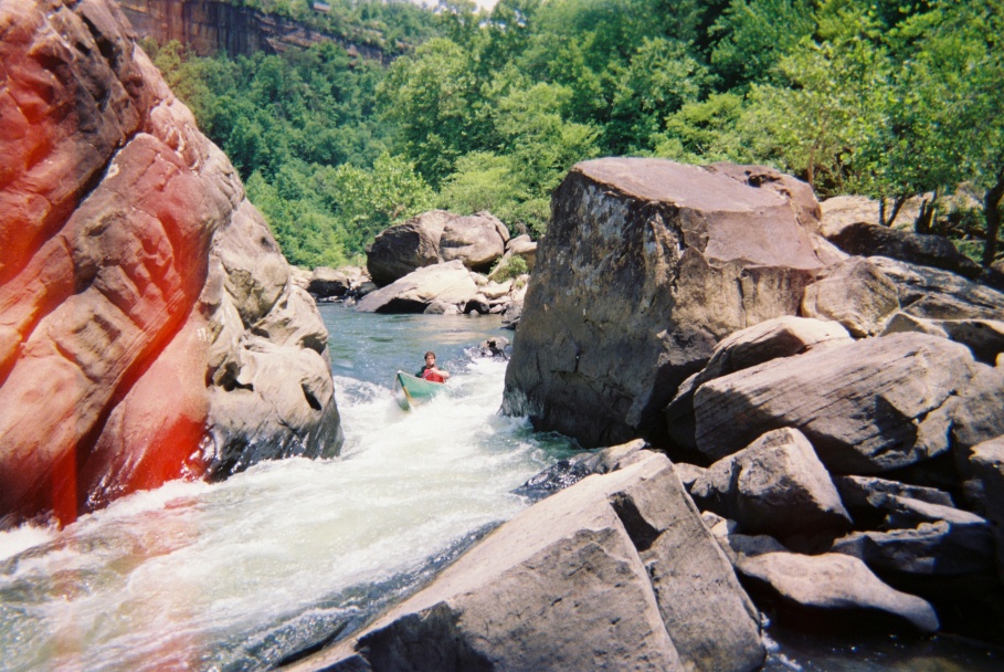
The second day is flat, dotted by a few Class I rapids, mostly after Station Camp. Station Camp is reconizable by horse trails and a small campground on the bank, plus a small rapid that runs through it. After Station Camp, the run gets a bit more livley, a few more Class I's show up, including a landmark, Big Island, which is a huge 13 acre island cutting the river in two. Run the left around Big Island. A Class II rapid cuts through Big Island, which is a deligtful place to eat lunch. After Big Island, the run gets faster. Class IIs start to show, and get more numerous. About the Tennesee/KY border is a huge cliff up on your left, which if viewed correctly, looks like a indian chief. This is where you should end your day, because the camping gets further and further apart past it. On the 3rd day, you enter the Big Shoals, which is a series about 7 miles long of almost continuious Class II, and one borderline III rapid, just upstream of Devils Jump. The whitewater is fun, and is prodominated by 2 ft waves, strong currents, small ledges, and long rapids. About 7 miles downstram of the KY/TN border, you should see a high mountain, which has a overlook on top. This is your signal to get on shore. Get out, and about 300 ft upstream is Devils Jump. A solid Class III, and in some books, a Class IV chute. It is where the entire river (100 ft wide) closes to a 5 ft wide chute, between massive boulders. At levels higher than 1500 cfs, the rapid should be portaged, because of possible hydracuils. But if you want to run it, run your boat straight at the chute, then turn your boat hard right, and you should go through no problem. After Devils Jump, about 300 yards is Blue Heron, marked by a small boat ramp. This is the main takeout, unless you want to go another 5 miles of dead water to Yamacraw Bridge.
The run is appox. 27 miles long, and is a good 3 day trip, but can be run in 2, but to have maximum fun, run it in 3. The fishing on the river is awsome, with smallmouth, walleye, and catfish the primary species. It is truly one of the greatest rivers in the south, and if you go down on Memorial Day weekend, and see about 8 canoes, full of guys, yelling WACO!!!, say hi, thats me and my group, and we'll help you out and point you in the right direction. This just may be my 3rd year, but some of these guys have been running it for ages!