Brush Creek
Confluence of Beaver Branch to confluence of Bluestone River
April 23, 2007
| Reporter | Robert S. Farmer |
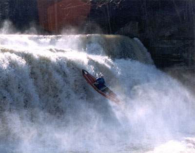
I caught this 4/18/07. I didn't run the upper section, but I noticed from the gorge rim that it appeared to be constant waves in a very scenic gorge. There is an old railroad trail that runs up it, although the bridge(s?) seem to be gone. It looked like fun, but maybe not for some Class 5 boaters. Also, if you put in at Eads Mill Rd, the shuttle is about 2.8 miles for what is probably a 5+ mile run---great for a bike shuttle. I did the lower section, starting from the Brush Creek Falls Rd bridge. This is, I would say, a 4-star section of creek, although it is short. If it were longer, I'd give it 5 stars. On the first day that I was here, the water was a bit high for me, so I scouted and waited a day to do it. There is an old railroad trail on the right that eventually becomes quite high above the river. It would make a nice shuttle trail, except that it is above cliffs at the takeout. A scouting hike here is a good idea; you want to know where the mandatory portage (or Class 7 at low water, anyway) is. If there are leaves on the trees, you may not be able to see anything. Starting at the bridge, there is a boulder sitting on a rock shelf on river left just upstream of the bridge. I ran this when the water was even with the top of the shelf directly below the boulder. This was an easy and fun level---optimum for a first timer! If the water is touching the boulder (+8 inches or so), that would probably be more Class 4-5. If the water is creeping up the boulder, the creek is probably going to be even more very serious. Below the bridge, there are two easy ledges that you should have scouted when driving down the road. The 35-foot, 2-stage waterfall (Class 5) comes after a long, flat pool. The first ledge drops into a trough that looks like a piton problem, but I found it to be well-padded even at the low level when I did it. Launch the main, 30-ft, straight-vertical drop near the middle; I penciled in just right of center in my short boat, and I had no problems. I've heard that it may be shallow on the right side. The next significant rapid is a pillowed boulder where the creek narrows. Paddle pretty much straight down the middle, slightly left-to-right, boof the boulder onto the pillow---it's maybe Class 4 (at this level). Below here is an island; left is Class 3, right is shallow. Below this island, slabs slope down to the left toward a hole that is unmistakeably dangerous at higher levels. There is a flat-topped rock on the left to mark this drop. I snuck it to the right, over a smooth ledge that slopes down to the left. At low water, this is too low to navigate, and it will push you leftward along the lip, probably backwards, maybe into the hole. Scout! Ironically, after sneaking the hole to the right, I noticed that it didn't look too bad at this level. Still, there was something strange about it, so scout carefully. After a trivial rapid or two, you come to a ledge. The left and center have a hole that may be sticky at higher levels. An easy, fun slide bypasses this to the right. Soon, you come to the approach for the Class 6-7 drop. This starts where the creek turns sharply left. I scouted on the right below a large tree that is growing out from the right shore; this eddy may wash out at higher levels. There is a large eddy downstream on the left, below a right-to-left ledge with a stout hole above a smooth, fast slab. I discovered that catching this eddy at this level is Class 5+, because I got blown right by it! I managed to catch a last-chance eddy above the Class 7 drop, but it was scary. Portaging from above the left turn might be better, or it might be possible to sneak down the left at higher levels. Whatever, be extremely cautious here! There is a large rock that blocks the creek from river left; the right side is overhanging, and a hole flushes into this undercut from about 12-15 feet downstream. At low levels, nothing can escape it, not even light, like black holes in space! It might be runnable at higher water, but definitely scout! Below here is an easy slide with an undercut shelf rock on the left; start far left, and build up left-to-right momentum. Class 3 rapids lead down to the Bluestone. At the Bluestone, exit left because the best takeout is straight across the river; the farther downstream (to the right) that you go, the harder the exiting will be. It's an easy 3/4 mile walk back to Eads Mill along an old railroad grade. Directions: Eads Mill Rd, CR 14 runs alongside, over, and under I-77 in S. WV between Exits 14 and 20. At Exit 14, it's the first left turn from the eastbound road. At Exit 20, it's the first left turn from westbound 19. 'Eads Mill' is just a former town. There are no signs or buildings; it is not marked in any way, shape, or form. It's just a forest alongside the river, now. There is a one-lane bridge. Upper Brush Creek crosses this road up higher (farther south). Brush Creek Falls Rd is an unmarked turn to the east across from address #6727, nicknamed 'The Green Isle' by its owner. When I did the creek, the level at the dam way upstream (http://waterdata.usgs.gov/nwis/uv?cb\_00065=on&format=gif\_default&period=9&site\_no=03178150) was 22.45. At the peak of the massive storm two days earlier, the level was 22.72. I don't know how helpful this will be, but there it is. Have fun, be careful!