Cranberry
AA (Upper): Above Cranberry Rec. Area to Cranberry Rec. Area
September 9, 2016
| Reporter | Mike Beswick |
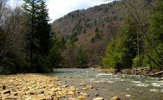
Got a rare summer run on the upper Cranberry, from the Cranberry glades lower parking lot, to the start of the middle section. It ended up being over 15 miles, which made for a long day. In my infinite wisdom, I suggested we hike in on an intersecting trail ( the cowpasture trail ) and put on in the WV version of a mangrove thicket. After hacking through alders for around 3/4 of a mile, we decided to hike back to forest road 102, and couldn't locate it. It is very easy to get turned around in the glades backcountry, and we ended up thrashing around in the woods for over an hour, finally putting on a small stream full of alders, wondering if we were on the right river. The thickets finally began to diminish, and the river ( the south fork of the Cranberry ) started flowing through beautiful spruce forest, resplendent with blooming rhododendron After several miles of this, the current picked up, small class 2 rapids emerged, and continued dropping steadily for many miles. Down near the confluence of the north and south fork, there was a solid class 3, followed by several more busy 2-3 miles. Then a section that I believe is called the Roughs suddenly appeared. It is marked by a strong, very busy class 3 ( maybe low 4) followed by a steep blind drop, followed by another 7-8 foot steep slide. Easily comparable to the tougher rapids on the middle Cranberry, including S turn. There was still another 5 miles after this, and Carson and I found our concentration waning, having put on around 1:30, and finishing up around 7: 30 ( including the close to 2 hours of aimless hiking and boating through alders ) I'd highly recommend the run, for scenic beauty, and a lot of variation throughout the duration of the run. Be sure to hike down forest road 102 until the river appears boatable, unless you have extreme masochistic tendencies.