Cranberry
AA (Upper): Above Cranberry Rec. Area to Cranberry Rec. Area
January 27, 2024
| Reporter | john wood |
| Gauge Reading | 4.7 ft at CRANBERRY RIVER NEAR RICHWOOD, WV |
| Flow | Medium Runnable |
River Description
AW rates this section class I-III but I feel that is somewhat misleading. While much of the run is easy class I-II there is plenty of II+, some nice class IIIs, and at least one easy class IV at the level we saw it. I agree with a previous trip report that one drop is just as hard as anything on the middle cranberry. Additionally, consider that this is a long wilderness run, with a continuous nature, and the water will likely be very cold when you run it.
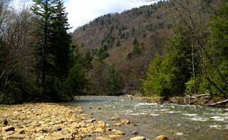
Generally, the river has a consistent gradient, continuous easy whitewater punctuated by larger rapids without pools
Most of the rapids near the top are shallow wave trains, but some boulder gardens appear without warning. The most serious rapids are found in “the roughs” below the confluence with the dogway fork. You will know you made it to the dogway fork when you encounter a low water bridge crossing the river.
One of the first bigger rapids is formed where a house-sized boulder on the left forms a chute on the right over some broken ledges. Another is a long but open class III boulder garden, the road is right next to the river for this one. The hardest rapid (class IV) is located between little rough run, and rough run. You likely will not notice these runs from the river but they are marked on topo maps. Just before the big rapid the river pushes against a small cliff face on the left and curves to the right.. The curve hides the rapid from you and it comes up fast. The road is high above the river here and portaging requires some rock scrambling. The rapid consists of 2 large ledges separated by about 100 feet of easy boulder garden, each ledge has a few chutes through it.
After the big one there are still 4 miles of paddling. There are a few more larger rapids after the big one, and then the river cools off all at once, taking on a more open gravel bar feel. There are still a few more class II+/ easy III rapids to look out for, but generally, the harder part is behind you.
Our experience (See Sean O'Malleys report of the same trip for another perspective)
We ran the upper Cranberry Jan 27 2024. The level was 4.7 when we put on and 4.5 when we took off. We elected to walk in a full 2 miles from the locked gate at the put-in before getting on the river, the road was covered in snow and it made dragging the boats easy, we could also see logs down across the river at the earliest put-in options. This put us just a few minutes paddle upstream from where the gravel road crosses the river on a bridge.
The upper section was mostly free of serious wood when we paddled it, though there were strainers that needed to be managed in areas where the river braided.
Mostly the rapids did not surprise us and we boat-scouted almost everything. A few drops did surprise us, even with good spacing the least experienced paddler in the group did not always have time to react to the signals being given by the lead boat and ended up running a few drops that they might have walked had they been able to find an eddy. We all commented how the general feel of the river (excluding the larger rapids) was like the Nantahala: narrow, fast, and cold, with consistent gradient, and no pools. If you are a competent class III paddler you will be fine on this river, if you paddle class III only occasionally, or have just reached that level maybe try a less committing river.
We had 2 safety concerns. At one point on the lower section below the roughs, a large log pushed against a river right boulder spanned the entire river. At first, it looked like there was a log on each side with a gap in the middle but once committed to the rapid the lead boat realized the log was covering the whole river. The first boat managed to boof onto it and then slide off the back, the second boat boofed it as well, and the other paddlers had time to eddy out and walk. The other challenge was running out of daylight. We started walking at 11:30, started paddling at 12:30, and reached the takeout at 6. A few more minutes and it would have been too dark to paddle. Give yourself plenty of time.