Clear Creek
1. US 127 to Barnett Bridge (Upper Upper Clear Creek)
February 7, 2005
| Reporter | James Locke |
Copied from Bill & Nancy on Boatertalk:
I am posting this because there is not much info available on this run.
Saturday Feb 5 2005
Overnight canoe camping trip. in an Old Town Discovery 15.6 float bags front and rear
Put on at 9:30 Jett bridge @ 3.1 feet don't know the cfs because some idiot got the gage taken off USGS UGH!
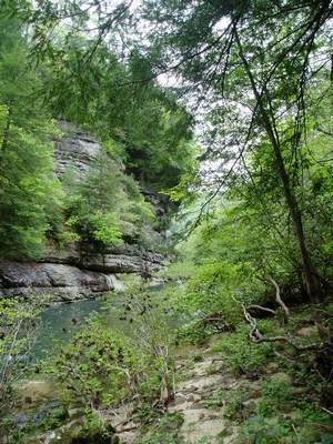
First six miles technical with a few bony spots. Very intimate , closed in cliffs, beautiful. One spot you paddle under a large rock house: COOL. Another spot a waterfall falls in over a rock house into the creek. You could camp inside the rockhouse behind the falls and it would be great because someone has built a fireplace complete with chimney in there. The morning sun shines through the waterfall creating an amazing display. YOu would probably need to make it a 2 night trip to use this site because it is only about 1 1/2 miles in. In this top stretch we had to carry once and had to get out of the boat about 3 more times and do a short slide over rocks due to some unrunnable(by us with a loaded canoe @ this water level) rock jumbles. I was beginning to get worried about making the trip in two days because we were not making good time and were getting tired. We flipped once the first day @ the bottom of a rapid. Made it 8 miles or so the first day. Very quiet. We heard only 2 small airplane engines on the whole trip and that was it for man noises. Water is swimming pool clear.
After the first 6 miles, the river opens up and takes on many small tributaries with the rapids becoming a little more powerful and getting a few waves. The second day went much faster. We did the last 12 or so miles in about 5-6 hours including one swim and one portage around a river wide tree, and a lunch break. With 5 more inches of H2O we could have blasted over this tree. The double drop at the end has been reported to be 1/2 mile from the end but my gps gave it as 0.74 miles. Be on guard. It looked runnable but the lead in is blind and appears to be just another class II wave train from right to left dissappearing on the left. eddy out on the right to scout/ portage. If you get on this wave train around the left you are comitted to running the rapid *about class III+ at this level- undercut bottom left! FOr some reason from upstream the noise of the rapid is muffled and it does not even sound louder that the many class I-II rapids on the run. We may have tried running it but we had had a good fright a few miles above. There are 2 or three rapids in the last 5 miles that have current blasting into large storage shed sized boulders. GOing by the rule that every rock in the Obed system is undercut, we assumed that they were undercut although this was not clearly visible. On one of these we missed our line and rammed head on into the rock. I went by the principle that if you are going to hit something, it is better to hit it head on. When it became clear that we would hit it, I just aimed for a head on collision. We rammed hard and broke the plastic nose piece of the boat. At least this stopped the momentum so that when we presently got pushed sideways into the rock we were able to lean in to the rock and hold the boat off with a heismanlike push to keep the boat from pinning. We lost both paddles and it was very dicey for a moment. Luckily we managed to hold the boat off long enough for us to eventually wash around the rock. One paddle was floating nearby and I grabbed it and retrieved the other paddle.
Summary:
\* 3.1 on jett is enough water. would be fun with less.
a lot more could get hairy for loaded canoe
\* Don't get discouraged by the first few miles. They are beautiful but rocky and full of pinning opportunities. the last half goes much faster.
\* This is a challenging trip with a loaded open canoe. I have been boating 10 years, kayak class IV nearly every weekend, raft guide in the summer, and canoe often, and this was a challenging trip for me. If you are not experianced, you will probably not die on this run, but you could end up hurt or with lost gear and a pinned boat and no 'reasonable' way to secure assistance. From our campsite there was no way within a short distance to hike out of the gorge unless you are a good rock climber with gear. Hwy 62 as about 1.5 to 3 miles North as the crow flies (river left). Hiking out would be very difficult.