Clear Creek
1. US 127 to Barnett Bridge (Upper Upper Clear Creek)
May 4, 2006
| Reporter | James Locke |
This is a trip report from Chota Canoe Clubs listserve about our trip last weekend:
The Mission: a route typically used for an overnighter
The Crew: Duckie Boy and The-One-Who-Needs-A-Real-Helmet
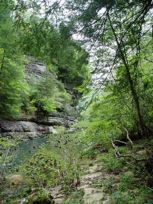
The Setting: Clear Creek from the 127 bridge to Barnett
The Level: 350 cfs at Lilly (consider it minumum for a day paddle). It had
peaked two days earlier
at around 750.
A beautiful Saturday dawned with a plan to meet at the Ranger Station in
Wartburg.
We knew there might be a little paddling involved (about 20 miles) so the
meeting time was set for 8am.
Put-on time: 9:23
The first several miles were very pretty although scrapy (lots of
wheelchair boating). The highlight
of that section was about 50 yards of the river where you ran under a wide
rock shelf (think of a taller
version of the cave on Island Creek)). Lots of scenic camping areas and
small waterfalls joined the
river, slowly raising the river level. Lots of dogwood still blooming and
the wild azaleas were thick
with white and pink blossoms. We had heard that the first few miles
dropped about 15 feet to
the mile, then went to about 40 before settling back down. The steepest
section had some pleasant
class 2 stuff.
A few areas had some portages. There were two rapids in
the first 8 miles that could
cause trouble with more water. Easily boat-scouted, but no obvious lines
at the low level we were using.
The toughest part was the '10 Mile Lake' in the middle. Although not much
more than one mile in
length, there is little as demoralizing as a long stretch of flatwater
followed by several more in
succession.
Around mile 16, we ran into 5 canoeists who had been on the river for two
nights and were going to
spend another night there. They were a little amazed at the distance we
had covered. Would have liked
to chat more, but we had a schedule to maintain. At this point, my
shoulders were starting to complain.
Around mile 19, we hit the only significant rapid on the stretch; Monte
Smith has a picture of it in
at least one of his books. A class 3, the biggest hazard is that you run
it blind. The river turns
to the left for about 30 yards and then turns back right. At that point,
you finally see the double
drop. Not a problem in a kayak, a loaded canoe should have everything tied
down. Plan on hitting
the line on the right if you can.
3/4 miles later, we were at Barnett bridge, a mere 6 and a half hours after
the put in.
The whole trip was like a wilderness hike where you could sit down the
entire time.
Recommended for strong paddlers who need a break from steep creeks, also
suitable for flat water
folks (easy portages except for the last rapid). If you do an overnight,
you can probably run it a lot lower
although the first four miles will take longer as you hike alongside your
boat.