Sauk Creek
* UPDATE 2025.09.05 Sketchy wood, but doable * Conservancy to S.Wisconsin St. (1.18 mile or 0.3 mile PnH)

| Difficulty | II-III(IV) |
| Length | 1.2 mi |
| Avg Gradient | 47 fpm |
| Gauge | Menomonee River at Menomonee Falls, Wi |
| Flow Rate as of 38 minutes | 2 cfsbelow recommended |
| Reach Info Last Updated | July 19, 2026 |
Quick Facts
Location: Port Washington, WI.
Put-in Parking: 43.39465 -87.88230 (Sauk Creek Nature Preserve)
Take-out Parking: 43.38634 -87.87241 (S.Milwaukee St.)
Shuttle Length/DriveTime: 1.1 miles/3 minutes.
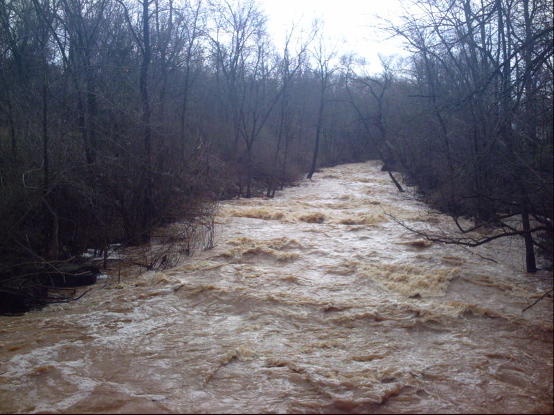
Gauge Info: Linked gauge is only an indicator of possible water in the area. The only reliable gauge is the plate gauge at Grand Avenue bridge (upstream river-right): under 14.0' is not recommended, 14.0'-14.5' is low (scrapey, but doable), 14.5'-15.5' is moderate, 15.5'-16.5' is high, and over 16.5' is very high. This has been run with the entire plate gauge submerged, later measured/approximated at 17.3' ... it was an amazing, wild, runaway-freight-train rush!
IF PLATE GAUGE IS SUBMERGED, do not put on without checking the 'Three Bar Bridge' (above Krueger Falls) for clearance!
Put-in elevation is approximately 660'
Take-out elevation is approximately 591'
Total drop is approximately 69'
10/85 Gradient Upstream of Put-in: 6 FPM
Percent Developed Upstream of Put-in: 6.6 %
The higher the above two values, the 'flashier' the stream will be. These are not high values, however, the drainage area is small, so flows will not hold up more than a day or so at a time.
Drainage area at put-in: 30.4 square miles
Drainage area at take-out: 32.3 square miles
Drainage increase: 6.3%
Class/rating and gradient is NEVER enough to decide if you should run a river/rapids! Far more important than gradient and class/rating should be other less-quantifiable 'character factors': continuous versus pool/drop, wide-open routes versus constricted technical rapids, wide-channel (with multiple routes) versus narrow channel (with essentially one route
...Just northwest of the conservancy parking on Moore Road/CTH.KK (and just past the railroad crossing), N.Spring Street branches due north and dead-ends (pardon the expression) into 'Norweigian Cemetery'.
The 5+acres between the cemetery and the railroad, along with nearly 11 acres between the railroad and the creek, are listed as 'City of Port Washington' properties.
In 2024, the power company or railroad company used massive brush-cutters to mow a path from the cemetery to (and all along) the powerlines along the railroad. If you went due east from the end of that road at the cemetery, that would put you somewhere very near the 'former' put-in location!
HOWEVER ...
So, all in all, it's just much easier to do the carry-up within the conservancy (as is detailed below).

For years the recommended put-in was thru woods just north of 949 N. Grant Street.
THIS IS NOT RECOMMENDED FOR MULTIPLE REASONS!
1) The owners at 949 own the adjacent wooded lots. You are trespassing unless you knock on their door, find someone home, and get permission to access the creek here. (That said, it's unlikely anyone will actually notice you if you quietly carry down and don't dally on shore before paddling away.)
2) More importantly, deadfall often blocks shore-to-shore from here to Krueger Falls. It will be awkward to portage multiple times (in just this quarter-mile of creek, with no real whitewater action).
A few folks expressed interest in trying to start at Hwy.LL, or Mink Ranch Road. That would add minimal gradient and rapids, and guaranteed plenty of additional deadfall encounters and portages. In short, don't bother trying to put-in anywhere upstream!
An alternate access would be to park near the corner of Grant Street+Walters Street. From this corner, there is a path which runs nearly parallel within the north border of the conservancy. Carry (about 300 yards) down the path, keeping to the right at any splits until you see the creek. This will bring you to the uppermost 'recommended' put-in.
HOWEVER ... with the wood situation (as of 2024.10.25), we cannot recommend putting in here! A total blockage will necessitate a portage within a minute downstream! Thus, you should then carry left/south about another 50-60 yards to be downstream of that blockage (or about 100-120 yards to our presently listed 'recommended put-in').
This (Grant Street/Walters Street) access is very nearly the same length carry as from our recommended parking/put-in location mentioned below. The 'upside' is that this is all downhill. However, the downside is that you don't get a 'preview' of Krueger Falls unless you make a stop there to scout before driving up to here to carry down and put on. So ... why putz with all that ... just use the following put-in!
Park roadside at the conservancy property (on CTH.KK/N.Moore Road). Carry down the path, across the footbridge, and upstream (left). At the first split in the path, stay left. You will cross a very brief bridge/boarwalk (over a swampy spot) to reach the top of Krueger Falls. If the creek is at runnable levels, you will have to wade through shallow water to scout the falls (visualize your 'markers' for your approach when in your boat).
After scouting the falls, decide upon your put-in. Reasonable options are:
North from this point (amid the pine trees), while there is still a very prominent path, YOU WILL BE ON PRIVATE LAND! YOU ARE TRESPASSING OUT OF THE CONSERVANCY! Everything upstream from here (to CTH.LL/Seven Hills Road, to I43, to Mink Ranch Road, and beyond) is lower gradient, and virtually guaranteed to have plenty of snag-filled areas with mandatory portages.
A small pitch in the bedrock will create a minor wave with just enough of a pool (and eddies) to allow some minor play to warm-up on before heading downstream.
When doing the carry-up from the conservancy parking, and after scouting Krueger Falls, this would be the most convenient put-in. However, we always prefer the previously mentioned spot, to be able to come down into this drop, to either catch-on-the-fly, or eddy-out to play this wave.
The approach to the falls is signaled by an old bridge. Three iron rails span the creek from a raised cement platform at river-left. At almost any good runnable flow this is a 'point of no return' -- once you pass it, you ARE going down the falls -- there is no stopping now!
At moderate-to-high flows, the point of no return is upstream a ways -- when you can first see the Three Bar Bridge or possibly before you can see it!
ALSO BE AWARE: at super-high flows, you may have little clearance under this bridge! Furthermore, there will very likely be roller-coaster waves leading under it, making it very awkward to know if you can duck at the right time! (This will be when the gauge/stick at Hwy.32/West Grand Avenue is completely submerged.)
Unfortunately the narrow creek spreads wide across the bedrock here, which means water will sheet quite shallow heading into the falls. Unless you have unusually high flows (>16.0'), expect to 'grunge out' no matter which line you take.
Far left, there is a sweet 'off-ramp' slide. (This is route is often somewhat obstructed by shrub willow from the left shore.)
Far right, another longer sliding 'off-ramp' would be passable only with very high flows in the creek (above 16.0' on the staff gauge). However, diagonal waves will likely push you toward center before you can get to this ramp!
Down the center, the creek falls off more abruptly. Left-of-center there is high piton potential. The better line (for those choosing not to run the left slide) is well right-of-center, coming off the lip with your right elbow or paddle-blade almost banging the right 'wall' of water (cascading off the right-side 'off ramp').
Immediately after the 'big drop', the bedrock slide continues (with small waves and holes which adventurous boaters may catch-on-the-fly for some play) until a small ledge before the footbridge. The ledge can become a bit sticky at certain flows, but more often does a good job of kicking you out. (Be aware that the river-right eddy can be challenging to exit at elevated flows! Also be aware there is a good-sized rock in the outflow of the deepest part of that hole.)
Before putting in anyplace upstream, one should ALWAYS scout the steepest gradient from this footbridge in the Conservancy property.
Parking is roadside, with a path (large-gravel) leading to a footbridge. Look upstream and downstream to check for trees in the flow. (There have been MANY trees falling into and across the creek, complicating or negating any possibiity of passage! As of 2025.08.25 passage is sketchy, but possible.)
To get a better look at the approach, cross the footbridge, turn left (north, upstream), and keep left where the trail splits. A mini-bridge (boardwalk crossing a very brief swampy area) leads to the brink of the falls. If the creek is at runnable flows, you'll need to be in wettable footgear to walk in shallow water, to get out where you can best see upstream and down, to get your 'visual markers' for where you need to be when in your boat.
Gung-ho boaters (having put-in and having run Kruger Falls) may wish to exit here to carry up for another quick run of the falls before continuing downstream. However, with the action just downstream, I generally continue down the next stretch, even though it means a longer carry for the 'park-and-huck' (or laps of this stretch before continuing to the listed/usual take-out).
After the brief pool under the bridge, the bedrock slopes away. At moderate flows, there will be some very interesting diagonal waves and holes which skilled boaters may wish to surf-on-the-fly. The final one has a short pool and decent eddies which can allow some (minor) repeat play. At high flows, this develops a wide (potentially retentive) hole.
Downstream, the stream-bed turns to rocks and concrete rubble, forming class I-II runout which continues almost unabated to the take-out (at least, at higher flows).
NOTE: I have walked the stream at minimal flows, and there IS a significant (extreme) amount of concrete slabs and rubble, with rough irregular edges. Anyone upside-down or out of their boat will be punished severely! (DO NOT TRY TO STAND UP IN ANY CURRENT!!!) Surprisingly, there is NOT a significant amount of rebar (metal reinforcing rod) as some people have rumored. (I'm not saying NONE, just not what I would call anything close to significant.)
To do laps on the steepest gradient (either when doing the full run with shuttle, or to avoid driving/biking a shuttle), the first reasonable exit after running Upper and Lower Krueger Falls would be at Pierre Road bridge. However, there are only minor eddies under that bridge (at moderate-to-high flows) and it is an extremely awkward climb on steep, wooded banks to get up to the sidewalk.
For easier exit, pass that bridge, and watch river-left for a spot to beach on a rocky shore. You will 'mantle up' a 3-4' vertical cement wall, walk upriver (to the north), to a gate in a chain-link fence surrounding the school football/baseball fields. It may be open, but more likely you may have to drop back down-and-up the wall again to get around it. (It may be possible to take out from the creek before going past that fence/gate, but there is little-to-no obvious marker, and the eddies are not generally as good.) It'll be about 0.3mi to the parking area at the conservancy, or a total of about 0.5mi (or more) if you want to put in for another lap.
A cement-slab bridge allows pedestrians to get from Moore Street to the high school athletic fields. While this bridge is generally high enough over the water as to not be a problem for boaters, amazingly it can collect wood (whole trees!) when branches get stuck into the undercarriage of the bridge!
It is a good idea to stop and scout from here while running your shuttle!
At times, some boaters may opt to take-out here, if they are just doing a 'park-and-huck' of the steepest gradient, and if it is too difficult or risky (flow is too fast) to attempt exit at any other point before this. The cement flanks supporting the ends of the bridge are 'stepped', but it will be an awkward climb (especially for shorter boaters), as they are tall 'steps' in the concrete.
After Athletic Fields Bridge, the creek bends left (east), then right (south). The bends are fairly tight, precluding seeing downstream. This zig-zag has periodically held large branches or whole trees in the water and significant overhanging branches and brush on shore. Since this area cannot be easily scouted before putting on, it is important to proceed with utmost caution!
Approach from the outside of a bend (river-right for a left-hand bend, river-left for a right-hand bend) to see as far around the corner as possible (to see problems early). HOWEVER, it is virtually mandatory to avoid being pushed too far to the outside of each bend, so as not to be swept into and become entangled in any brush or snags alongshore! This is especially crucial in the second (the right-hand) bend here!
So ... the solution? Position your boat toward the outside of the bend, but point your bow toward the inside of the bend! (You'll be completely sideways or even slightly backwards -- leading with the stern!) You can then use strong forward strokes (as needed) to move your boat quickly away from the outside of the bend when and where necessary!
An old USGS staff gauge (metal plate) is affixed to the leading right side of the bridge. This can be checked from shore before making your run, or checked from your boat as you pass through this location.
13.9' to 14.2': Bare bones minimum, total boat abuse. (Most boaters won't bother.)
14.2' to 14.5': Marginal (scrapy, but potentially fun, if you've never done it before).
14.5' to 14.8': Getting decent, but still 'thin' coming down Krueger Falls ('Minimums' for serious boaters.)
14.8' to 15.3': Getting juicy! (Low-Medium for serious boaters)
15.3' to 16.3': WILD (Medium-High for serious boaters.)
16.3'-17.0'+: WOWIE KAZOWIE! Freight train rush! Virtually no stopping start to finish!
NOTE: The plate gauge goes to 17.0'. If it is submerged, check 'Three Bar Bridge' in the Sauk Creek Conservancy for clearance before putting on upstream of it!
An old bridge pier (long defunct bridge) splits the flow This location is likely to accumulate snags and strainers.
ALWAYS SCOUT THIS SPOT BEFORE SHUTTLING UP AND PUTTING ON!
From the take-out parking area: walk west (upstream) on the paved pathway until you see a clearing where the shore has slumped into the creek and where the bridge pier is visible. Carefully look as far upstream and downstream as possible (often tough to do with all the shrubbery blocking the view from shore).
The bridge pier can provide an interesting dynamic eddy to catch. Downstream, there are some 'fish habitat structures' which have been added to the streambed, but generally will be unnoticed by boaters at boatable flows.
The best take-out (for shortest hike back to your vehicle) is immediately under the Wisconsin Street bridge. A hill of dirt on shore (just before the bridge proper) creates a great eddy against the river-right cement wall of the bridge. Beach your boat and walk tot the top of that hill. Hoist your boat up to the grass at the top of about a 5' wall. It may be a tough climb up the wall (especially for shorter boaters), as you have to 'mantle up' (rock climbing move) to the grassy area immediately behind a fish-cleaning station (with rest rooms).
There is a good-sized parking area immediately adjacent, but it has been fenced in (low wood/rail fence) and marked exclusively for use by WE Energies vehicles. Best I can tell, it is still legal to parallel park outside that fence along an alley, or at the west end (outside the fence) next to a powerline post.
An alternative take-out now exists downstream of the bridge. Vertical walls used to flank both sides of the river. The right wall has been laid back and landscaped. It will be a bit of a carry to anyplace that you can park your vehicle (either at the aforementioned location, or at an improved parking area in a peninsula/park immediately northeast of the powerplant and overlooking the harbor, called Coal Dock Park).
This being a far more visible location (with fishermen, people walking the sidewalks, etc), and preferring to keep much more of a 'low profile', I strongly prefer to take out under the Wisconsin Street Bridge, and enjoy the shorter carry to the vehicle(s).
As the creek reaches the lake, it encounters remnants of a small dam or weir, most of which has been broken out. Some rebar remains. Depending upon river level (flow) and lake level (which varies year to year, decade to decade), the weir can form a really nasty hydraulic. (With recent high lake levels, this weir is totally underwater and a non-issue.)
The WE Energies powerplant discharges cooling water immediately adjacent (to the right), which contributes to the unusual currents found here. Fishermen love this spot, hanging lines from the pathways flanking this location, so be alert!
A final option (especially if someone had a yard sale (swam) and group members had to give chase to boat(s) and paddle(s), which are likely to make it all the way to the lake/harbor) is to paddle to the area of huge quarry rock.
It will be awkward to empty water from boats (if need be), and awkward to climb up the rocks. A bonus here is a public restroom, located by the corner of the harbor area (separate from and behind the Duluth Trading Company building).
Mar 27, 2017
For what it's worth, regarding reference gauges: While Cedar Creek (and it's gauge) are a good bit closer to this creek, it has considerably larger watershed, as well as considerably different 'flashiness' in the flow pattern. For this reason, we do NOT use it as an indicator for Sauk Creek. The Menomonee Falls gauge has more similar drainage area and should have much more similar flow patterns ('flashiness'). As always (with 'reference gauges' such as this) correlations to are not assured. It will always be necessary to get on-site look at conditions to assess runnable flows.
Jan 1, 1900
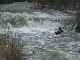
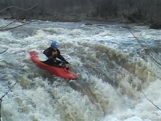
Erik Larsen Cruizing over the main ledge.
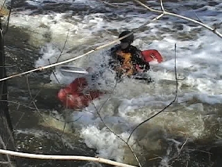
This hole (immediately upstream of the footbridge in the park) can be surprisingly retentive and can offer good side surfs. Use caution if you flip, however, as failure to roll here can mean a long, mean swim down shallow sloping ledges downstream with very powerful current.
The main drop on this run lies in a park (conservation area), and convenient paths allow easy multiple runs.
Sweet waves and rapids lead into and follow the main drop for quite awhile.
Don't even consider swimming or standing anywhere on this river when it is at runnable levels. Large, sharp, broken concrete slabs under the water, boulders, fast current, old parking meter posts, tons of strainers, and other debris are in this river. Therefore, beginners should avoid this river unless accompanied by an experienced paddler.