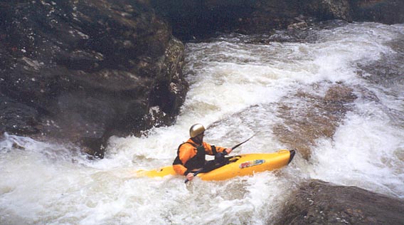
Cooper Creek
Barker Camp Rd to Bowater Parking Lot
December 20, 2001
| Reporter | Brad Roberts |
From Tony Robinson on Boatertalk
' New stick gauges were recently installed on Cooper and Cain creeks. Last Sat. when Cain read 6' on the traditional gauge, the new gauge read 1.5'. This gauge is located on a bridge over Cain 2 miles upstream. It is located 1/2 mile down a newly graveled road on the right .9 miles past the Cooper creek bridge. There is a yellow sign advertizing land for sale. If you pull down to the right, you don't even have to get out of the truck. Six inches is a minimum level on Cain, so if you are concerned Cain is too low, check the upper gauge first. Another use would be to know if Cain was too high before you hike all the way down to the river and paddle down to the gauge and have to hike back out, but there is no info on how a max level would coorelate.
The new Cooper gauge is located at the Barker-Camp Road bridge. Cooper was run last Fri. at 2.3' on this gauge, a reportedly beefy level(N. Chick was 3.6'). I'm guessing 1.9 would be a good minimum level. Speaking from experience, the best way to run Cooper is to not put in on Cooper, but rather to run Cain/Chick down to it at a big level then hike up the last 1/4 mile of Cooper. Since all the good rapids are located in it's last 1/4 mile before emptying into N.Chick, you get to do all of them plus Cain/Chick at a great level. The Cooper trail starts at a large dead pine tree on river left 30 yards upstream of it's confluence with N. Chick. The trail is on Cooper's right side and takes you to the top of upper Cooper Connection. It's a rough trail, but clear.
Gauges were also installed on Big Soddy, Falling Water, and Woodcock creeks. The Big Soddy gauge is located on the Back Valley rd. bridge at the takeout. The Falling Water gauge is on the first bridge upstream of old Hwy 27. The Woodcock gauge is on the first road bridge upstream of Hwy. 127. There is no info yet on how these gauges coorelate to levels.'